USGS - science for a changing world

NAWQA Land Use/Land Cover (LULC) Characterization

For Internal USGS Access Only
NAWQA Land Use/Land Cover (LULC) Characterization

LULC Characterization
Home

GW Design Guidelines

Workplan Guidance

Data warehouse

NAWQA
Intranet || Public

Water
Intranet || Public

USGS
Intranet || Public

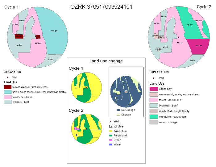
Maps showing land use within 500-m of the well and land-use change between cycles

The spatial data used to create these maps is available.

Example land use mapThe following maps (all in PDF format) show land-use characterization within 500 meters of wells sampled by the USGS National Water-Quality Assessment Program to study land-use effects on water quality. Cycle 1 (1991-2001) and/or cycle 2 (2002-2013) land use at each site is displayed along with an indication of land-use changes.

Land use/land cover is described and shown using detailed categories. In some cases land use was inconsistently mapped between cycle 1 and cycle 2.  Sometimes cycle 2 land use was characterized by someone who did not use the previous cycle 1 land-use characterization as a guide.  This resulted in apparent land-use changes when, in reality, land use did not change between cycles.  Sometimes inconsistencies appear in the identification of a land-use category (for example: identifying an area as 'mixed forest' in cycle 1 but as 'deciduous forest' in cycle 2;  or identifying an area as 'residential mixed housing' in cycle 1 but as 'farm residence/farm structures' in cycle 2) and other times inconsistencies are in the delineation of the land-use area (for example delineating a road as a separate category in one cycle but including it with adjacent land use in the next cycle). Other apparent land-use changes are because some of the spatial data from the different cycles do not align exactly due to spatial misalignment of DOQs which were used as a backdrop for digitizing. In order to display gross land-use changes over time and to compensate for some of the inconsitencies, the land use was aggregated to level 1 categories and is also shown on the maps.

The maps reflect data archived as of 01/09/2009. Contact Terri Arnold tlarnold@usgs.gov for more information or look at the USGS internal-use web page: http://water.usgs.gov/nawqa-only/luchar/

These maps were created by Kevin Jungk and Jacqueline Thomas under the direction of Terri Arnold during the Summer 2008.

Combined Cycle 2 SUID Study Unit Study Unit Name PDF
File Size (Mb)
All Study Units All study units in 1 file. This is a BIG file 108 winzipped
ACAD Acadian-Pontchartrain Drainages 4
ACFB Apalachicola-Chattahoochee-Flint River Basin 5
ALBE Albemarle-Pamlico Drainage Basin 4
ALMN Allegheny and Monongahela River Basins 2
CAZB Central Arizona Basins 8
CCYK CCPT Central Columbia Plateau 8
YAKI Yakima River Basin
  CNBR Central Nebraska Basins 2
CONN Connecticut, Housatonic and Thames River Basins 8
PODL DLMV Delmarva Peninsula 8
POTO Potomac River Basin
  EIWA Eastern Iowa Basins 4
GAFL Georgia-Florida Coastal Plain 5
GRSL Great Salt Lake Basins 2
HDSN Hudson River Basin 3
HPGW High Plains Regional Ground Water Study 5
KANA Kanawha - New River Basins 2
LERI Lake Erie - Lake Saint Clair Drainages 4
LINJ Long Island - New Jersey Coastal Drainages 5
LIRB Lower Illinois River Basin 4
LSUS Lower Susquehanna River Basin 7
TENN LTEN Lower Tennessee River Basin 4
UTEN Upper Tennessee River Basin
WHMI MIAM Great and Little Miami River Basins 9
WHIT White River Basin
  MISE Mississippi Embayment 3
MOBL Mobile River Basin 3
NECB New England Coastal Basins 2
NVBR Las Vegas Valley Area and the Carson and Truckee River Basins 6
OZRK Ozark Plateaus 3
PUGT Puget Sound Basin 3
REDN Red River of the North Basin 4
RIOG Rio Grande Valley 7
SACR Sacramento River Basin 4
SANA Santa Ana Basin 2
SANJ San Joaquin-Tulare Basins 8
SANT Santee River Basin and Coastal Drainages 4
SCTX South-Central Texas 3
SOFL Southern Florida 5
SPLT South Platte River Basin 7
TRIN Trinity River Basin 4
UCOL Upper Colorado River Basin 2
UIRB Upper Illinois River Basin 3
UMIS Upper Mississippi River Basin 4
USNK Upper Snake River Basin 7
WILL Willamette Basin 5
WMIC Western Lake Michigan Drainages 5


U.S. Geological Survey Intranet
URL: http://water.usgs.gov/nawqa-only/luchar/LUMaps.html
Page Contact Information: Terri Arnold (email tlarnold)
Page Last modified: Monday, 15-Nov-2010 09:52:21 EST