USGS - science for a changing world

Science In Your Watershed

Science in Your Watershed
triangle icon Home
triangle icon Locate Your Watershed (Legacy 8-digit HUC)
triangle icon Locate Your Watershed by 12-digit HUC
triangle icon Links By Watershed

triangle icon Information Discovery
triangle icon Active Projects
triangle icon Databases
triangle icon Publications
triangle icon Reports

triangle icon Data Integration:
triangle icon Watersheds
triangle icon Education

triangle icon Case Studies:
triangle icon Analysis
triangle icon Assessment
triangle icon Characterization
triangle icon Management
triangle icon Stream Restoration

triangle icon Customer Service
triangle icon Glossaries
triangle icon Conferences/Events

triangle icon [Gateway to Watershed Information] [Know Your Watershed] [How's My Waterway] [Science in Your Watershed] [Watershed Gateways] [Watershed Gateways]

USGS Home | Core Science | Ecosystems | Energy and Minerals Mission Area | Natural Hazards | Water

Science in Your Watershed

Locate Your Watershed (Legacy 8-digit HUC)

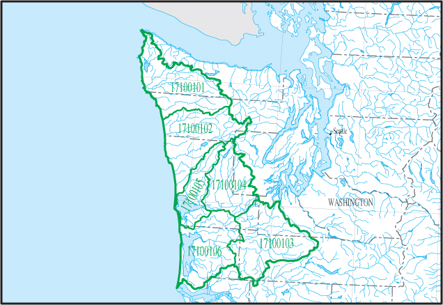
Click on a Cataloging Unit Boundary (17100101) Hoh-Quillayute (17100102) Queets-Quinault (17100104) Lower Chehalis (17100105) Grays Harbor (17100106) Willapa Bay (17100103) Upper Chehalis Please Select a Cataloging Unit Within the Map Area
Click on the Map Above to View a Particular Cataloging Unit Boundary

USGS Water How's My Waterway Know Your Watershed HELP!

Accessibility FOIA Privacy Policies and Notices

USAGov logo U.S. Department of the Interior
U.S. Geological Survey
URL: https://water.usgs.gov/wsc/acc/171001.html
Page Contact Information: Webmaster
Page Last Modified: Thursday, 20-Jun-2024 16:53:22 EDT