The Importance of Ground Water in the Great Lakes Region
Water Resources Investigations Report 00 - 4008
|  Previous Page | Back to Contents | Next Page Previous Page | Back to Contents | Next Page | |
How does ground water move in the Great Lakes Region?
Aquifers and
confining units (relatively impermeable rocks and sediments) make up the
ground-water system in the Great Lakes watershed. This system stores water and
acts as a conduit for water to move from recharge areas to discharge areas (fig. 3). Recharge takes place between streams in
areas that occupy most of the land surface. Ground water moves in both local
and regional flow systems.
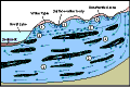
Figure 3. Generalized local and regional ground-water flow systems in the Great Lakes Region.
Most ground water moves in local flow systems
To improve our understanding of the importance of unconsolidated aquifers in the Great Lakes watershed, new geologic maps that show the extent, thickness, and boundaries of these aquifers are needed.
Ground water in local flow systems commonly travels relatively short distances underground before
discharging to a stream, lake, or wetland. The Great Lakes Region has an
abundance of small streams, and most ground-water flow takes place in these
shallow systems. The amount of ground water moving through these systems is not
well quantified, however, because most water-supply studies have focused on
deeper regional flow systems. The most productive shallow aquifers are composed
of sand and gravel (fig. 1). The extent of
these deposits near the land surface is commonly known and illustrated on maps,
but the thickness and capability to transmit water often is not well known. To
improve our understanding of the importance of ground-water flow in
unconsolidated aquifers in the Great Lakes watershed, new geologic maps that
show the extent, thickness, and boundaries of these aquifers are needed
(Central Great Lakes Geologic Mapping Coalition, 1999).
Most ground water for municipal supply comes from regional ground-water flow systems
More work needs to be done to define and quantify the interactions between regional ground-water flow and ground-water discharge to the Great Lakes.
Regional ground-water flow systems are usually deeper below land surface and have longer flow paths than
local flow systems (fig. 3). Confining units
that restrict flow of water between the systems commonly separate local from
regional flow, but thick, unconfined aquifers may have regional scale
ground-water flow. In the Great Lakes Region, regional ground-water flow occurs
in both glacial deposits and bedrock aquifers, depending on the hydraulic
properties of the aquifers and confining units, and the topographic
relief.
Figure 4. Estimated ground-water withdrawal rates for some major U.S. metropolitan areas (data not available for Canadian areas).
Glacial deposits usually consist of a complex assemblage of sediments (fig. 3).
In some parts of the region, glacial deposits are as much as 1,200 feet in
thickness. As thickness increases, the complexity of the sediment assemblage
usually increases. These sediments need to be mapped using established
three-dimensional mapping techniques to understand their geological framework
(Bhagwat and Berg, 1991). Hydraulic characteristics of the sediments also need
to be determined for the aquifers that are increasingly being tapped for water
supply. Armed with this hydrogeologic characterization, water managers will be
able to make better determinations of sustainable withdrawal rates from the
region's aquifers.
The extent, thickness, hydraulic properties, and general directions of flow in the most used bedrock
aquifers have been described by regional aquifer studies conducted by the USGS
(Sun and others, 1997) and by State and local agencies (Bleuer and others,
1991; Batten and Bradbury, 1996; and Passero and others, 1981). Although these
studies provide a baseline of hydrologic and geologic information, more work
needs to be done to define and quantify the interactions between regional
ground-water flow and ground-water discharge to the Great Lakes. Divides that
are transient barriers to ground-water movement are established by a
combination of natural and human-induced stresses on the aquifers. In some
areas, bedrock aquifers may discharge large quantities of water to the lakes,
but the data needed to quantify the amount of flow have not been collected. In
addition, the effects on the Great Lakes of pumping from regional aquifers are
unknown. Many ground-water issues take time to be recognized, but, because of
the large volumes and resulting long travel times for water in regional flow
systems, the time lags expected are usually much longer than for local flow
systems. Thus, adverse effects of withdrawals may take years to manifest
themselves.
How is ground water replenished?
Ground-water recharge rates estimated in previous studies represent the approximate range of recharge to the water table in the entire Great Lakes Region. A comprehensive study for the entire watershed is needed to more completely determine the importance of ground water in the hydrologic budget of the Great Lakes.
Recharge is the term that is commonly used to describe the process of adding water to the ground-water
system. Although it is difficult to directly measure the amount of recharge, it
is important to estimate recharge rates to understand the effects of ground
water on other hydrologic processes in the basin and to assess how activities
at the land surface may change the recharge rates. The amount of recharge can
vary considerably throughout the basin depending on soil type, precipitation
(rates, types, timing, and amounts), and other factors, including the extent of
impervious surfaces (roofed and paved areas) and storm sewers. For example, the
amount of water that infiltrates into a sandy soil is usually greater than that
into clayey soil. Recharge rates in Michigan's Lower Peninsula range from
nearly 0 to about 23 inches per year (Holtschlag, 1997). Ground-water recharge
rates estimated in previous studies represent the approximate range of recharge
to the water table in the entire Great Lakes Region. A comprehensive study for
the entire watershed is needed to more completely determine the importance of
ground water in the hydrologic budget of the Great Lakes.
![[Image: Figure 5 - Generalized ground-water flow]](images/tn-IJCfig05.gif)
Figure 5. Generalized ground-water flow (A) under natural conditions and (B) affected by pumping (Note that surface - and ground-water divides are coincident in A but not B).
Urban development may reduce recharge amounts because impervious surfaces (such as roads, buildings, and
paved areas) often drain to storm sewers, a situation that increases surface
runoff and reduces infiltration. These processes may significantly alter
ground-water conditions in many urban settings by "short-circuiting" to streams
and lakes water that would have infiltrated to the water table. They also may
increase flood potential. Currently, only 7 percent of the Great Lakes
watershed is classified as urban; therefore, the effects of urbanization on
ground-water recharge are likely to be localized and the effects on the
watershed as a whole may be minimal. Because urban areas are rapidly expanding,
however, it is important to continue to monitor the effects of urbanization on
ground-water recharge rates. Other activities associated with urban expansion,
such as increased ground-water pumping, along with reduced recharge rates may
increase the drawdown of water levels caused by pumping.

Figure 6. Decline in water levels in the sandstone confined aquifer, Chicago and Milwaukee areas, 1864-1980. (Modified from Avery, 1995.)
Recharge to bedrock aquifers is
less well understood than that to unconsolidated aquifers because infiltrating
water may need to move through several layers of geologic material before
reaching the bedrock aquifer. Direct measurement of recharge rates to bedrock
aquifers is difficult. Estimates of these rates have been made in the USGS
Regional Aquifer-System Analysis studies (Sun and others, 1997) mostly by
simulating regional ground-water flow with digital models. These rates vary
considerably from place to place, but generally are much lower than the
estimates of recharge to the water table, especially for non-pumping
conditions.
| Previous Page | Back to Contents | Next Page |
| 