USGS Groundwater Information
Groundwater Resources Program
![[Photo: Ground water flowing out of well.]](http://water.usgs.gov/ogw/gwrp/images/flowingwell-vsm.jpg)
New & Noteworthy
USGS Groundwater WatchUSGS maintains a network of active wells to provide basic statistics about groundwater levels. ![[Image: USGS active water level wells location map.]](http://groundwaterwatch.usgs.gov/sm_ogw.png "USGS Groundwater Watch")
Other Water TopicsUSGS in Your StateUSGS Water Science Centers are located in each state. ![[Map: There is a USGS Water Science Center office in each State.]](/ogw/images/usmapsmall.gif)
|
Contents | Introduction | Importance of Ground Water to the Nation | Evolving Ground-Water Issues and USGS Programs | Relationship of GWRP to Other USGS Programs | Current Activities of the GWRP | Future Priorities for the GWRP | Concluding Remarks | STRATEGIC DIRECTIONS FOR THE U.S. GEOLOGICAL SURVEY GROUND-WATER RESOURCES PROGRAMA Report to CongressNovember 30, 1998FUTURE PRIORITIES FOR THE GROUND-WATER RESOURCES PROGRAM
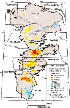
Future plans and proposals considered for the program emphasize four themes: scientific assessments of critical ground-water issues, regional and national overviews, improved access to ground-water data, and research and methods development. These themes are discussed in the following sections. Scientific Assessments of Critical Ground-Water IssuesA flexible approach is needed to address diverse issues. In some cases, studies are undertaken for major aquifer systems, such as those ongoing for the Middle Rio Grande Basin and in south Florida. In other cases, issue-based studies focus on multiple aquifer systems over a broad geographic area, such as the ongoing studies of the southwestern United States and Atlantic coast. For discussion purposes, key issues considered by the program are grouped according to five topical areas: ground-water depletion, ground-water/surface-water interactions, freshwater/saltwater relations, subsidence, and ground water in complex geologic environments. A brief background on each issue, with selected examples from across the United States, is given below. Examples cited are for illustrative purposes and are neither exhaustive nor prioritized. Ground-Water DepletionWidespread pumping that is sufficient to cause regional declines in ground-water levels can have several consequences. Wells can become dry or have greatly reduced yields as water levels decline. Pumping costs increase as the distance that ground water must be pumped to the land surface increases. Large decreases in aquifer storage can result in substantial ground-water mining with less water available for future users. Areas of significant ground-water depletion in the United States include, among others, the High Plains aquifer, many areas in the southwestern United States (e.g., AZ, CA, NM, NV, and TX), the Sparta aquifer in the southeastern United States (AR, LA, and MS), and the Chicago-Milwaukee area. Long-term observation-well networks are needed to provide data to monitor areas of ground-water depletion. Water allocation and development decisions must be based on an accurate set of facts about the changing status of the resource. Water-level monitoring takes place for many aquifer systems within States, but with the exception of the High Plains aquifer (Figure 6), coordinated water-level monitoring generally has not been done for ground-water systems that cross State boundaries. In order to provide the information needed on large aquifers, a rotational assessment of water-level changes on these major systems should take place at least every 5 to 10 years.
Figure 6. The High Plains aquifer covers eight States in the central United States. Irrigation has made the High Plains one of the Nation's most important agricultural areas. Extensive pumping has depleted ground-water storage in the aquifer, as indicated by this map of water-level change from 1980 to 1995. Although ground-water pumping has decreased over the past decade in much of the High Plains, water levels have continued to decline significantly in some areas because withdrawals still exceed recharge. Ground-water levels have risen in other areas as a result of decreased pumping or recharge from surface-water irrigation. (Modified from U.S. Geological Survey Water-Resources Investigations Report 97-4081.) Information on the amounts of ground water pumped from different aquifers is needed to characterize areas of overdraft. This water-use information is critical to the development of predictive models and decision-support systems to make realistic projections of the effects of alternative management strategies. Currently, the USGS works with State agencies to provide water-use data on a geographic basis such as was shown in Figure 1. Significant advances in the prediction of water-level declines depend on obtaining more accurate data on pumping, consumptive use, recharge, and surface-water return flow using remote sensing and other advanced techniques.
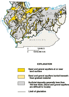
Ground-Water/Surface-Water InteractionsTraditionally, management of water resources has focused on surface water or ground water as if they were separate entities. Yet, nearly all surface-water features (streams, lakes, reservoirs, wetlands, and estuaries) interact with ground water. Actions taken with one part of the system often have had unintended consequences with the other parts of the system. As development of land and water resources intensifies, it becomes increasingly important to manage ground water and surface water as a single entity. The nature and degree of the hydraulic connection between ground water and surface water varies considerably from place to place and from terrane to terrane. For example, the interaction in the arid southwest, which has few perennial streams, is usually quite different from the interaction in the humid northeast where perennial streams are more commonplace (Figure 7).
Figure 7. Sand and gravel aquifers in areas that underwent continental glaciation (such as much of Illinois, Indiana, and Ohio) and in alluvium along rivers (such as the Ohio River) are important sources of ground water. Pumping from these aquifers near streams can induce water from the stream into wells and change the quality of water supplied for drinking. The amount and type of ground-water/surface-water interactions vary in complex ways that depend on factors such as geologic properties, pumping rates, stream stage, and streambed material. (Modified from U.S. Geological Survey Hydrologic Investigations Atlas 730-K.)
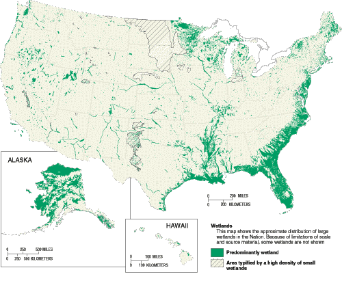
Ground-water/surface-water interaction is a particularly complicated aspect of wetland hydrology (Figure 8). Long-term ground-water studies in wetland environments are needed to support effective management of natural, restored, and newly created wetlands. Likewise, riparian zones adjacent to waterways where vegetation is strongly influenced by the presence of water also require special attention. The status of ground water near streams is critical to determine how riparian zones protect water quality and biodiversity, and how they buffer lands from flood damage. The need for a federal effort is reinforced because of the important trust responsibilities for threatened and endangered species that rely on the streams, wetlands, and riparian zones. Tools also are required to aid in quantifying the influence of ground-water development on changes in the interstate movement of water in rivers and in supporting watershed programs of various management agencies.
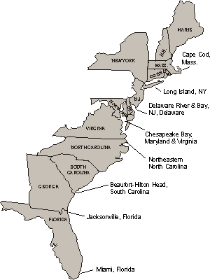
Figure 8. Understanding wetland hydrology will be improved if the relationships between ground water and wetlands are more clearly established. Wetlands occur throughout the United States and cover large areas in the north-central and northeastern United States, coastal areas along the Atlantic and Gulf coasts, riverine terrain in the lower Mississippi River valley, and Alaska. (Modified from U.S. Geological Survey Water-Supply Paper 2425.) Freshwater/Saltwater RelationsThe fresh ground-water resource of the United States is virtually surrounded by saltwater. The problem of saltwater intrusion is associated most commonly with excessive withdrawals of ground water from aquifers that lie adjacent to the ocean or tidal waters. Ground-water pumping can reduce freshwater flow toward coastal discharge areas and cause saltwater to be drawn landward. In extreme cases, such landward movement can result in supply wells being abandoned where saltwater reaches pumping centers. In addition, the decrease of freshwater flow to the coastal environment can change the salinity of coastal waterways and wetlands, thereby affecting the habitat of plants, fish, and wildlife. Significant water-level drawdowns also can cause saline water that underlies freshwater in much of the interior of the country to move vertically upward into wells. Incidences of saltwater intrusion into freshwater aquifers have been documented in almost all of the coastal States. In some areas, water-management techniques have been developed to help control saltwater intrusion; for example, Los Angeles and Orange Counties in California operate artificial recharge programs, and the Miami area in Florida has a program to adjust the freshwater levels in canals. Along the eastern seaboard States (Figure 9), saltwater intrusion has been documented in many of the aquifers at various depths. The severity of saltwater-intrusion problems varies substantially among localities and hydrogeologic settings. Effective regionwide planning of ground-water and surface-water development depends on knowledge of the location of the saltwater interface and ability to predict its future movement based on factors such as ground-water pumping, surface-water withdrawals, and sea-level change. Freshwater inputs to coastal wetlands and estuaries are important national issu es because of the habitats these areas provide. Examples of areas where the freshwater inputs are a concern are Chesapeake Bay, Florida Bay, and Great South Bay, Long Island.
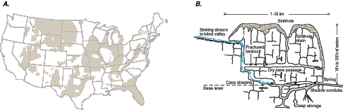
Figure 9. Development of ground-water resources along the Atlantic coast has caused saltwater to intrude many highly productive freshwater aquifers. Projected future growth in population along the coastal areas of the United States will likely increase stresses on coastal aquifers and ecosystems that depend on freshwater discharges from these aquifers. Selected areas along the Atlantic coast where saltwater has intruded freshwater aquifers are shown. During the next 2 years, the USGS will prepare an assessment of freshwater-saltwater relations along the Atlantic coast. SubsidenceIn some areas of the country, land subsidence can result from a decrease in subsurface support caused by the withdrawal of ground water. Subsidence can severely damage wells, buildings, and highways, and create problems in the design and operation of structures for drainage, flood protection, and water conveyance. Subsidence in response to ground-water withdrawals can continue over months or years after water levels stabilize and can cause an irreversible loss of storage capacity in aquifer systems. Subsidence from ground-water withdrawals occurs throughout the United States. It is most common in heavily developed aquifers in the southwestern United States and from sinkhole collapse in limestone aquifers in the southeastern United States. There is a strong federal interest in subsidence because subsidence problems pose significant threats to federally funded infrastructure, such as highways, runways (e.g., the runway used for the Space Shuttle at Edwards Air Force Base), and canals (e.g., the Central Arizona Project). Also, in areas near coastlines, subsidence can increase coastal flood risks, which entail potential economic losses that will create demands for federal disaster mitigation or recovery funds. An ongoing appraisal of the status of ground-water systems that are at risk from subsidence is needed. Ground Water in Complex Geologic EnvironmentsGeologic environments that are extensive areally, but have unique common physical characteristics that govern the movement of ground water, require special attention when assessing the Nation's ground-water resources. For example, traditional hydrologic methods are mostly ineffective in limestone and other "karst" areas characterized by sinkholes, caves, and underground drainage from dissolution of rocks (Figure 10). Karst systems are highly susceptible to contamination. Aquifers in karst regions supply much of the Nation's ground water for drinking-water supply. Many National and State Parks are located in karst regions because of the existence of caves. Similar difficulties exist in characterizing many other types of geologic settings in which the presence of fractures, faults, and other geologic features adds a significant complexity to understanding the availability and sustainability of ground water (Figure 11). Permafrost, which underlies about 80 percent of Alaska, is another poorly understood, but widespread, environment. Permafrost changes the hydraulic properties of the materials in ground-water systems because the frozen parts of the system do not transmit water easily. At the present time, the potential importance of permafrost in Alaska has increased because it has been suggested that much of the permafrost is warming or thawing because of recent climatic conditions.
Figure 10. (A) Much of the Nation is underlain by carbonate rocks or gypsum that are exposed at the land surface or are in the zone of active ground-water circulation. (B) In many areas, these rocks, which are slowly soluble to ground water develop caves and other karst features, making it particularly difficult to evaluate ground-water conditions. (Modified from Back, W., Rosenshein, J.S., and Seaber, P.R., eds., 1988, Hydrology: The Geology of North America, v. O-2, Geological Society of America, and White, W.B., 1993, Analysis of Karst Aquifers in Alley, W.M., ed., Regional Ground-Water Quality: Van Nostrand Reinhold.) Regional assessments of ground-water resources and development of better predictive tools are needed by public agencies and by those in the private sector who are attempting to address water availability and contamination issues in these complex geologic environments. Recent efforts of the USGS joining the talents of the Water Resources Division and the Geologic Division (such as the ongoing work in the Middle Rio Grande Basin, NM) have led to significant advancements in ground-water science that can be expected to produce better decision-support systems for aquifer management. A long-term goal is to capitalize on recent geologic and geophysical research in geologically complex environments and use it to improve understanding and management of ground-water systems.
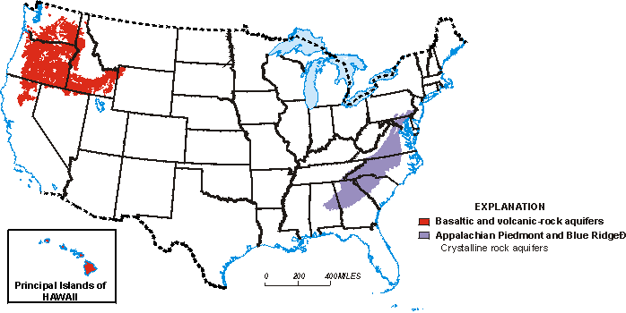
Figure 11. Hydrogeologic environments throughout the United States are highly varied and include many complex settings in which it is difficult to characterize the availability and sustainability of ground-water resources. For example, areas that were subject to large sequences of lava flows, such as the Columbia Plateau, the Snake River Plain in Idaho, and the Hawaiian Islands, commonly have very productive ground-water systems. Aquifers in this terrane yield water mainly from zones between lava flows and are controlled by fracturing and weathering. A second example are crystalline rocks of the Appalachian Piedmont and Blue Ridge in which the ground-water system is comprised of bedrock and an overlying layer of loose unconsolidated rocks, referred to as the regolith. The hydraulic connection between the regolith and fractures in the bedrock controls the water-supply potential of many aquifers in this rapidly growing, highly urbanized and farmed region. Regional and National OverviewsDuring the past 75 years, several summaries of the state of the Nation's ground water have been completed by the USGS. O.E. Meinzer, who has been called the "father of ground-water hydrology in the United States," published the first of these summaries in 1923. Meinzer's publication was followed by State-by-State and regional summaries on ground-water resources in the 1950's, 1960's, and 1970's. These national and regional overviews have increased our knowledge about the Nation's ground-water resources. Each has been followed by another as the places ground water is used, the amounts needed for supply, and the issues of concern all change. Regional and national overviews on a continuing basis would provide an ongoing status report of the Nation's ground-water resources. Such a status report would serve as a central source of information for policymakers who are addressing development and environmental issues that involve ground-water resources. Long-term consideration is being given to ways of producing a national overview on a decadal basis by rotating among a set of regional overviews. Close coordination would be required with the NAWQA and Coop Programs to maximize the effectiveness of such national overviews by taking advantage of the important data these programs can provide. Access to Ground-Water DataData are the foundation for scientific work and are an essential underpinning of attempts to evaluate alternative water-management plans. Several forces are shaping future needs for ground-water data. The types of data needed are expanding as new issues arise. New types of interpretive studies are using data in many ways not previously anticipated. Because of the ability to merge data from many different sources, the sharing of data for multipurpose needs is becoming more commonplace and essential. Data needed to characterize a ground-water system include both site data on the characteristics of wells and geospatial data on the characteristics of aquifers (e.g., three-dimensional extent and hydrologic and geochemical characteristics over a region). Easy-to-use interfaces are needed to provide ground-water data from wells on the Internet, but considerable effort remains to carefully evaluate and ensure the quality of ground-water data bases for a broad range of possible uses. Preliminary planning also is being done for a National Aquifer Data Base that would serve as a central and readily available source of geospatial information on ground water. Development of the data base will be coordinated with other data bases within the USGS, the State Geological Surveys, and other agencies, as well as guidelines established by the Federal Geographic Data Committee (FGDC). Collectively, these activities could lead to much greater availability of ground-water data for a multitude of purposes ranging from the individual land owner siting a well to persons developing decision-support systems for regional water management to policymakers at the national scale. Users include a diverse set of local, State, and federal government agencies; universities; nongovernmental organizations; and private-sector firms. Research and Methods DevelopmentThe USGS has been in the forefront of devising new analytical techniques to solve practical problems in the study of ground water. Predictive models are needed for informed decisionmaking in many emerging areas related to the environmental effects of ground-water development. For example, new methods are needed to better address how shallow aquifer systems interact with streams, lakes, and wetlands. Also, complex geologic environments require new methods of data collection and analysis. New models and methods developed will enhance USGS programs, but they also become the tools employed by State and local governments and ground-water scientists and engineers in the private sector. Research and methods development is an important part of the ongoing studies in the Middle Rio Grande Basin, south Florida, and the southwestern United States. |

![]() U.S. Department of the Interior |
U.S. Geological Survey
U.S. Department of the Interior |
U.S. Geological Survey
URL: http://water.usgs.gov/ogw/gwrp/stratdir/future.html
Page Contact Information: Contact the Groundwater Resources Program
Page Last Modified: Tuesday, 03-Jan-2017 20:47:24 EST