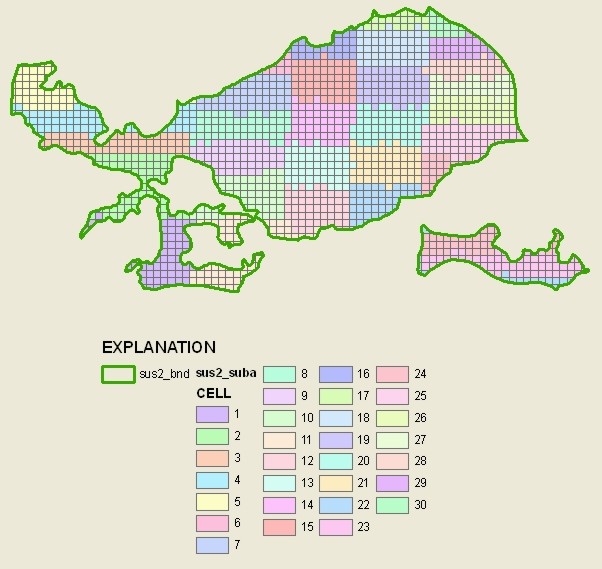
- acadsus4 (BND, and SUBA)
- acadsus5 (BND, and SUBA)
- nacppas1 (BND, and SUBA)
- mobllusrc2 (BND, TRG, and SUBA)


Fall 2012 National Data Request
Guidelines for Preparing Groundwater GIS Coverages for National Data Aggregation
October 12, 2012
Purpose
This document describes how to prepare the groundwater GIS coverages requested for national aggregation.Timetable
The response date for sending the GW GIS data to JoAnn Gronberg is November 30, 2012. Check the status log for a list of responses to date.Scope
We are requesting the following:
GUIDELINES FOR SUBMITTING LUS, MAS, and PAS BOUNDARY AND CELL POLYGON COVERAGE(S)
Polygon coverages are requested, however shapefiles or geodatabases are also acceptable. Please follow the guidelines (below) as they apply.
The study unit Groundwater Specialist and GIS specialist should work together to complete this request. The study unit Groundwater Specialist should prepare the metadata with the help of the GIS Specialist.
Circular 1112 by Gilliom and others contains a description of cycle 1 groundwater study design, the selection of agricultural land use studies, and well selection strategy, which still apply to cycle 2 design.
The urban land use study plan contains information about the urban land use design.
Please prepare coverages for:
a) For example, for a major aquifer study (sus1), an agricultural land-use study of vineyards (lusor1a), and an agricultural land-use study of almonds (lusor2a) in the eastern San Joaquin Valley alluvial fans, the SANJ study unit would first prepare a coverage that represents the boundary of the eastern San Joaquin Valley alluvial fans. This boundary also would be the overall boundary for LUS studies because it defines the areal extent of the groundwater being sampled.
Although the same polygon represents the overall boundary of the MAS and both LUSs, SANJ would provide one coverage for each network: 1) one for the MAS, 2) one for the vineyard LUS, and 3) one for the almond LUS. Each coverage would have a customized metadata file that describes how the wells were selected for that network.
In this example, these coverages would result:
OVERALL BOUNDARY      SUCODE
1.  SUS1_BND          xxxxsus1
2.  LUSOR1A_BND       xxxxlusor1  (same as SUS1_BND)
3.  LUSOR2A_BND       xxxxlusor2  (same as SUS1_BND)
b) If a land-use study was not nested within one of the major aquifer studies, submit a separate coverage representing the overall boundary of the hydrogeologic unit within which the LUS is located and metadata for that coverage.
OVERALL BOUNDARY     SUCODE
1.  LUSCR1_BND       xxxxluscr1
c) For a principal aquifer study (pas1), submit a coverage representing the overall boundary of the hydrogeologic unit and metadata for that coverage.
OVERALL BOUNDARY     SUCODE
1.  PAS1_BND       xxxxpas1
Each time a network is sampled, the associated targeted land use area should be clear. If the targeted area changes, it should be updated, but the original coverage, which was relevant to previous sampling, will be retained.
Most of the time, we would expect the targeted area to be stable from cycle 1 to cycle 2, with any replacement wells falling within the original area.
Continuing the example from #1a, the targeted land use for the vineyard LUS would be the intersection of the vineyards land use with the San Joaquin Valley alluvial fans and the targeted land use for the almonds LUS would be the intersection of the almonds land use with the San Joaquin Valley alluvial fans. Each targeted land use LUS coverage would be nested within the corresponding overall boundary coverage.
SANJ would submit a metadata file for each targeted land use coverage. The coverage metadata should describe the relation of the LUS to the overall boundary coverage and how the wells were selected.
TARGETED LAND USE     OVERALL BOUNDARY                          SUCODE
1. LUSOR1A_TRG         1.  LUSOR1A_BND  (same as SUS1_BND)      xxxxlusor1a
2. LUSOR2A_TRG         2.  LUSOR2A_BND  (same as SUS1_BND)      xxxxlusor2a
In the second example #1b, one coverage of targeted land use would result:
TARGETED LAND USE     OVERALL BOUNDARY                        SUCODE
1. LUSCR1_TRG         1.  LUSCR1_BND  (not an SUS)            xxxxluscr1
Here is an illustration showing the concept of LUS boundaries being nested within the MAS boundary. (This example contains three gif files, each about 6 KB.) (See also the map showing the location of ground-water chemistry sites in Circular 1159, p.24, for a similar example.)
The "targeted" coverage for the urban land-use studies should be the coverage that results from the intersection of the areal extent of the aquifer being studied with the residential/commercial land use (minus transportation and industrial land use), provided that the wells were located to achieve at least 75 percent new residential/commercial land use. The "targeted" coverage should be the same one used for random selection of drilling sites. If you have questions as to which coverage to submit, please consult the urban land use study plan or contact Curtis Price (cprice).
This is the polygon coverage of equal-area cells generated using the stratified random well-selection program, SAMPLE.AML (Scott, 1990) when the random selection with equal-area distribution method is selected. This coverage is named <rootname>_suba. See this example of a cell coverage from UIRB. A polygon coverage of equal-area cells for each LUS, MAS and PAS should be provided.
If a method other than equal-area distribution was used to select the sampling sites, then specify in the metadata for the network boundary coverage which method and options were used to randomly select the sampling sites for the network.
For example, SANJ would submit a metadata file for cells generated for each MAS and targeted land use coverage. The coverage metadata should describe how the wells were selected, including the choices made when using the SAMPLE.AML software (Scott, 1990).
 CELL FOR TARGETED LAND USE      SUCODE
1. LUSOR1A_SUBA                   xxxxlusor1a
2. LUSOR2A_SUBA                   xxxxlusor2a
3. SUS1_SUBA                      xxxxsus1
Principal aquifer studies would submit a metadata file for cells generated for each PAS coverage. The coverage metadata should describe how the wells were selected, including the choices made when using the SAMPLE.AML software (Scott, 1990).
 CELL FOR TARGETED LAND USE      SUCODE
1. PAS1_SUBA                      xxxxpas1
Please name each coverage according to the NETCODE of the groundwater study.
For example, SUS1_BND, LUSCR1_BND, or PAS1_BND
For example, LUSCR1_TRG or LUSRC1_TRG.
For example, SUS1_SUBA, LUSCR1_SUBA, or PAS1_SUSA
Please cross-check the coverage names with the NAWQA netcodes stored in NWIS, and use the coverage name and suffix as described above so it will be unambiguously related to its sampling well network. For example, if the netcode for a cropland land-use study is luscr1 (for example, acfbluscr1), name the coverage LUSCR1_BND or LUSCR1_TRG. Do not name the coverage LUSAG or AGWELLS or LUSCR1. You can check the valid NETCODEs for your study unit by using a NAWQA Data Warehouse Easy Query to list networks
Please use the following projection parameters for the coverages:
Projected Coordinate Systems
Continental
North America
USA Contiguous Albers Equal Area Conic USGS
Projection    ALBERS
Datum         NAD83
Spheroid      GRS80
Units         METERS
Zunits        NO
Xshift        0.0
Yshift        0.0
Parameters
  29 30  0.0 /* 1st standard parallel
  45 30  0.0 /* 2nd standard parallel
 -96  0  0.0 /* central meridian
  23  0  0.0 /* latitude of projection's origin
0.0 /* false easting (meters)
0.0 /* false northing (meters)
Please include the following fields in the coverage .pat files:
Minimum required items:

     AREA           4 12 F 3
     PERIMETER      4 12 F 3
     NETCODE_BND#   4  5 B
     NETCODE_BND-ID 4  5 B
     SUCODE        12 12 C    Please enter SUCODE as lower case.
Minimum required items:

     AREA           4 12 F 3
     PERIMETER      4 12 F 3
     NETCODE_TRG#   4  5 B
     NETCODE_TRG-ID 4  5 B
     SUCODE        12 12 C    Please enter SUCODE as lower case.
Minimum required items:

     AREA            4 12 F 3
     PERIMETER       4 12 F 3
     NETCODE_SUBA#   4  5 B
     NETCODE_SUBA-ID 4  5 B
     SUCODE         12 12 C    Please enter SUCODE as lower case.
     CELL            4  5 B
Please prepare an ASCII file of FGDC-compliant metadata to describe each coverage. (Metadata tools are available to guide this process. For additional assistance please contact Curtis Price, or Naomi Nakagaki.) Name the metadata file COVERNAME.met.
The coverage documentation must STAND BY ITSELF--that is, people should be able to use the coverage documentation to answer basic questions about the groundwater network design without having to go back to planning design papers and other supporting documents. Please make sure that the metadata files give detailed information about the groundwater network and well selection process. The study unit Ground-Water Specialist should prepare the metadata with the help of the GIS Specialist.
Here is an EXAMPLE of the METADATA contents for a fictitious groundwater study.
Please explain in the documentation how the coverage was used in selecting the well locations and other unique features of the study design. Please describe the process/criteria for selecting the wells and what source coverages (e.g., geology, physiography, hydrology, and so forth) were intersected to derive the study boundary. If wells had to be replaced or added, please describe whether the replacement wells were sited within the original study area. Please describe any changes in the study boundary if the study was expanded or combined with another study or otherwise revised. Please record information about what type of land use is being studied, what crop types or urban areas are involved, and so forth. Please include what netcode corresponds to each boundary coverage.
Please verify that the groundwater sampling sites are located within the groundwater study areas as defined by the GIS coverages. If some of the sites are located outside the boundary of the corresponding study area, please determine whether the boundary of the study area needs to be changed or whether the coordinates of the stations need to be verified. If the GIS coverage and a site location are correct, but a site still falls outside of the GIS boundary, then the documentation for the boundary coverage should explain why this occurs. For example, the documentation could state that the site was verified in the field to be sampling the correct location and the correct aquifer, but the hydrogeologic unit or land use coverage is generalized.
Please include in the metadata for the equal-area cells, the options used while using the SAMPLE.AML program, for example, method type, number of cells, etc. You can refer to the dated watchfile that is generated as a result of running the random sampling program. The watchfile would be named sample.xxxxxx.zzzzzz where xxxxxx is the date the SAMPLE.AML was run and zzzzzz is a number assigned by the aml.
If a method other than equal-area distribution was used to select the sampling sites, then specify in the metadata for the network boundary coverage which method and options were used to randomly select the sampling sites for the network.
If you prepare a "master" metadata file and use a copy of this file as the start for the metadata for each specific data set, please remember to tailor each succeeding file to the particular data set being described. If references to the first data set remain in the succeeding metadata files, the metadata does not make any sense.
Please verify the following:
Each polygon coverage can be made up of a single polygon or many discontiguous polygons.
All polygons WITHIN the groundwater study should be coded with a valid SUCODE. A valid SUCODE should correspond to the SUID + NETCODE used to create the coverage name. Use lowercase letters for SUCODE. Please use the standard netcodes described in the Cycle II Network Coding Guidance and verify you are using a valid sucode.
All polygons OUTSIDE the groundwater study, including the universe polygon ("null polygon") and any interior polygons that are "cut out" of the groundwater study, should be coded with a blank SUCODE.
Please correct any errors identified by CHECKDATA.
You can use ArcCatalog to create the metadata but please export the metadata to ASCII text and verify that each metadata file is "FGDC-compliant" according to Peter Schweitzer's metadata parser (mp).
Please correct any errors identified by mp.
Copy the groundwater coverage(s) and ASCII metadata file(s) into an empty folder suidgw, where suid is your 4-letter study unit abbreviation (SUID).
Select this folder in Windows Explorer, right click, and choose "Send to > compressed (zipped) folder." You can answer "No" to the question "Do you want to designate Compressed (zipped) Folders as the application for handling ZIP files?"
Copy the resulting file (suidgw.zip) to enterprise ftp - ftp://ftpint.usgs.gov/private/wr/ca/sacramento/Gronberg/gwbnds/ - or attach the file to an email message to Jo Ann Gronberg (jmgronbe@usgs.gov). (Enterprise ftp provides centralized file transfer service.)
Please email Jo Ann Gronberg (jmgronbe@usgs.gov) when the files are available in the ftp directory. Please include in your email any other explanatory material you think is necessary for us to understand your submission. Thank you.