|
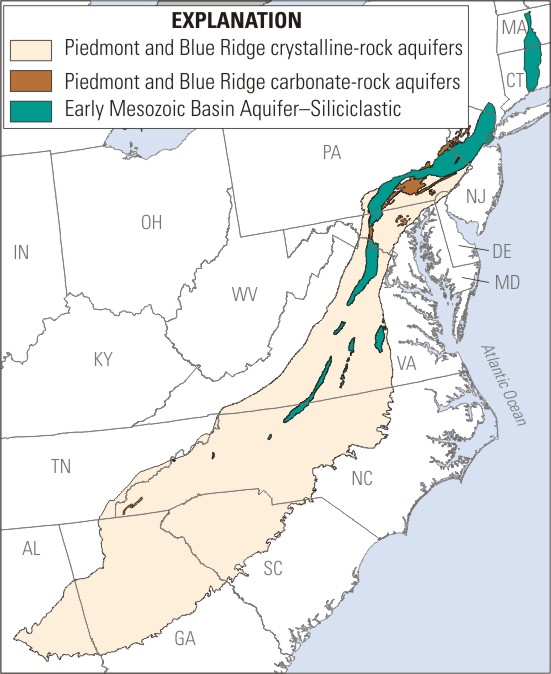
 The Piedmont Aquifer system (PAS) covers an area of about 78,000 square miles in the Piedmont Physiographic Province. The Piedmont is topographically divided into uplands and lowlands. The uplands are primarily igneous and metamorphic rocks, hereafter termed crystalline aquifers, that are resistant to erosion and form the hilly terrain. The lowlands are made up of clastic sedimentary rocks and carbonate rocks. The Mesozoic Lowlands, hereafter termed siliciclastic aquifers, are made up of sandstones and shales and formed in a rift basin. The sandstones and shales are locally intruded by diabase. Limestone, dolomite, and marble of Paleozoic age form the carbonate aquifers. These three basic rock types (crystalline, siliciclastic, and carbonate) form the three basic units used to stratify the Piedmont. The crystalline rocks make up 92 percent of the land within the Piedmont. Siliciclastic and carbonate rocks are 7 and 1 percent of the Piedmont Physiographic Province, respectively.
The crystalline aquifers are made up of igneous and metamorphic bedrock predominantly composed of silicate minerals. These rocks range from coarse-grained gneisses and schists to fine-grained phyllites and metamorphosed volcanic rocks.
The carbonate aquifers are made up of mostly limestone and dolomite bedrock and are the most productive of the Piedmont aquifers (Trapp and Horn, 1997).
Siliciclastic aquifers are primarily in three major basins—the Newark Basin in New Jersey and Pennsylvania, the Gettysburg Basin of Pennsylvania and Maryland, and the Culpeper Basin of Virginia. The Siliciclastic aquifers underlie the Piedmont Lowlands, which is relatively flat, undulating terrain. The siliciclastic aquifers are bounded by faults that formed basins that were filled with thick sequences of sedimentary rocks (thicknesses of Triassic and Jurassic rocks greater than 20,000 feet in the larger basins) of fluvial and alluvial origin (Trapp and Horn, 1997). The aquifers are made up of mostly sandstone and shale bedrock formed from silica sands and silicate clay minerals, respectively.
Bibliography
Hydrogeology of the Aquifer -- Ground Water Atlas of the United States
|