
U.S. Geological Survey
National Water-Quality Assessment Program
USGS Internal Access Only
Water-Quality Issues
I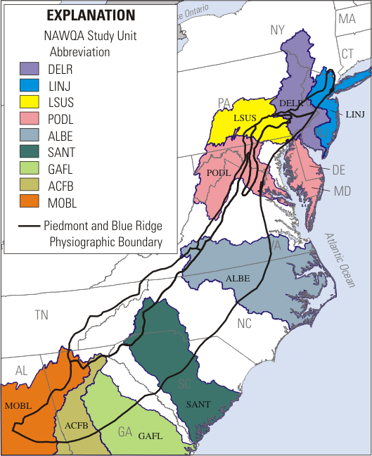 n Cycle I, eight ground-water studies were completed in the PAS. These included six major aquifer studies and two land use studies. In spatial coverage, the northern part of the Piedmont was sampled more densely than the southern part of the
Anthropogenic Contaminants in Ground Water
The discussion of anthropogenic contaminants in water will focus on similarities among and differences between the aquifer types. For this analysis, however, variations in land use overlying the aquifer in general and at each well are a factor that makes this analysis difficult. The difficulty arises in trying to conclude whether a given aquifer is actually less susceptible to contamination or the contaminant source is simply not present near a well sampling location. The approach will be to discuss aquifer type and land use in general, and attempt to draw conclusions from the information available. Of the eight studies conducted, only two were land-use studies. The ACFB conducted an urban land use study and the LSUS conducted an agricultural land use study. The remaining six studies were subunit surveys that had a mixture of land use types. In general, these are rural and suburban areas; however, the land uses surrounding each well was not considered in this analysis.
Nitrate
One of the major anthropogenic contaminants analyzed by all of the studies was nitrate. Nitrate is commonly the dominant form of nitrogen found in ground water. Concentrations of nitrate above 3 mg/L are considered an indicator of anthropogenic activity. The results of the nitrate analysis illustrated in figure 5 shows several themes. One is the susceptibility of the carbonate aquifer to nitrate contamination (fig. 5, lsuslusag1). Carbonate aquifers have numerous features that allow direct contamination of the aquifer, and this area also has significant inputs of fertilizer and manure (Lindsey and others, 1997).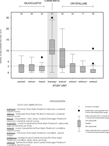
The study that documented the second highest median nitrate concentration was the lsussus2 subunit survey of a crystalline aquifer, in an area with high inputs of fertilizer and manure (Lindsey and others, 1997). This shows that crystalline aquifers with high inputs of nitrogen have potential for high nitrate concentrations. The statistics from the land use/land cover within a 500 m radius of the wells in the delrsus1 study indicated the land use to be 46 percent agricultural, 33 percent forested, and 18 percent urban. Samples from wells in this study had the third highest median nitrate concentration. The samples from wells in the urban land use study had the next highest median nitrate concentration. Samples from wells in the remaining studies had low median nitrate concentrations, and interpretations of these data would probably show that land use surrounding the well was a significant factor affecting nitrate concentrations. Only the lsuslus1 and lussus2 studies had median concentrations greater than 3 mg/L; however, all of the studies had at least one sample with concentrations greater than 3 mg/L (fig. 5).
Pesticides
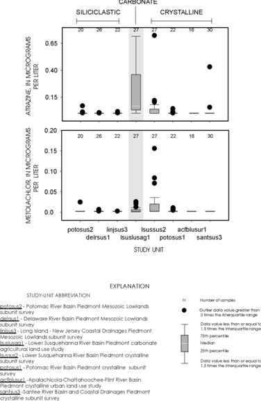
Pesticides are another set of major anthropogenic compounds analyzed by all NAWQA studies. The analysis of pesticide concentrations for this assessment of the PAS was based on atrazine, the most frequently detected pesticide in ground water samples collected by the NAWQA program, and metolachlor, a pesticide that ranks high in use, but has a lower detection frequency in ground water (Pesticide National Synthesis Project, 1997). The pattern observed for atrazine and metolachlor was similar to the pattern for nitrate, with higher concentrations and frequent detections in the carbonate aquifer and the crystalline aquifer with a high percentage of agricultural land use (lsuslusag1 and lsussus2, fig. 6). The delrsus1 study had a higher detection rate of these pesticides than the linjsus3 study. Although both are Siliciclastic aquifers, the agricultural land use in the two areas may have been more in the delrsus1 study and the use of both metolachlor and atrazine are much less in the LINJ overall than in the DELR study unit. Several studies had a small number of detections of the two pesticides. This would be expected for the urban study (acfblusur1) where agricultural pesticides are not commonly used. In the other areas it is difficult to determine whether the result is because the aquifer is not susceptible or the chemicals are not used in significant amounts.
VOC’s
The interpretation of volatile organic compounds (VOC’s) occurrence for this assessment of the PAS is based on the analyses for chloroform and methyl-tert butyl ether (MTBE) in six of the eight studies. Samples from the POTO study unit were not analyzed for VOC’s. Detections of chloroform were highest in the delrsus1, linjsus3, and santsus3 studies. Detections of MTBE were highest in the delrsus1 and linjsus3 studies. The significance of these findings may be masked by the lowering of detection limits from the 1991 study units to the 1994 study units. The detection limits for chloroform for the 1991 and 1994 study units were <0.20ug/L and <0.0520ug/L, respectively. The detection limits for MTBE for the 1991 and 1994 study units were 0.20ug/L and 0.170ug/L, respectively. It is difficult to make an accurate comparison of the low number of detections of chloroform and MTBE in the urban land use study (acfblusur1--a 1991 study unit) to the DELR, LINJ, and SANT studies which have data reported at a lower detection limit (fig.7) A reanalysis of the data at a common detection limit would be useful in determining the differences caused by the change in detection limit.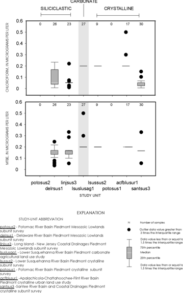
In general, the aquifers studied in the
Weaknesses of the available data from individual study units
for NAWQA Regional Synthesis of Ground Water in the
Piedmont Aquifer System
Spatial coverage
A major weakness of the assessment of ground water quality in the PAS is the inadequacy of coverage and spatial distribution of samples. The Cycle I sampling provides a minimal assessment. The carbonate (about 1 samples every 30 square miles--1,000 square mile area and 27 samples collected) and siliciclastic (about 1 samples every 80 square miles--5,400 square mile area and 70 samples collected) areas have been sampled with a density that may be adequate to categorize the water quality in those areas; however, the crystalline aquifer has a very low sampling density of about 1 samples for every 770 square miles (71,500 square mile area, 96 samples collected). With regard to spatial distribution of that sampling, the large area south of the Potomac River Basin has had only 47 samples collected to characterize water quality (30 samples for the SANT and 17 wells and springs sampled in the Atlanta area for an urban land use study by the ACFB study unit). Agricultural activity is a significant land use factor affecting ground water quality in the PCRY area and, due to the broad area underlain by this aquifer, the type and intensity of agricultural land use is likely to vary from one part of the PCRY area to another. Indications from the LSUS study of the crystalline aquifer indicate that intense agricultural activity may result in elevated concentrations of agricultural contaminants in ground water.
Categories of Contaminants
A major weakness of interpreting various contaminants in the PAS is that sampling for the various NAWQA schedules was not complete even within the areas that were sampled. The gaps in spatial coverage are even more dramatic when individual constituents are considered. VOC samples were collected in only 132 of the 193 ground-water samples. The samples from the siliciclastic aquifers and carbonate aquifers had VOCs analyzed in all studies with the exception of the POTO study unit. In the PCRY aquifer, only 56 samples are available to characterize water quality in the major aquifer, with 30 of those being in the SANT study unit. An additional 17 samples were collected in the ACFB urban area. This information, coupled with the change in detection limits in Cycle I, make the ability to conclude anything about the vulnerability of the Piedmont Crystalline Aquifer to VOC contamination very limited.
Another category of contaminants that has not been sampled throughout the PAS is trace elements. Trace element contamination can be from naturally occurring materials in the aquifer or anthropogenic activity. There were 17 samples collected in the PCRY urban study in the ACFB, 30 in the SANT PCRY major aquifer study, and 24 samples collected in the LINJ PSIL major aquifer study. The lack of data on trace elements makes it difficult to draw conclusions about the natural variability in occurrence and if occurrence indicates vulnerability of the PAS to trace element contamination.
Land use
The lack of sampling in all of the agricultural land use types is also a major weakness of the study. Land use within the PAS is not uniform. This is particularly important for understanding agricultural contaminants. The dominant crops in the northern Piedmont (POTO, LSUS, DELR, LINJ) are corn and soybeans, however, the dominant crops in the southern Piedmont study units (ALBE, SANT, GAFL, ACFB, MOBL) are cotton, peanuts, corn, tobacco, and soybeans. Dairy farms are the predominant form of animal agriculture in the northern Piedmont study units, whereas combinations of dairy, hogs, and poultry are the norm to the south. These variations in agricultural land use, especially crop production, indicate that pesticide use is variable throughout this region as well. The ability to determine vulnerability within an aquifer with this level of diversity of agricultural activity is difficult with the number of samples collected. This is particularly important because the aquifer tends to be dominated by short, local flowpaths. To assess water quality in a specific land use area, samples would need to be collected in the direct vicinity of those land uses.
Land use change is an important issue as well. The PSIL area within the PAS is experiencing rapid growth and is an area of significant reliance on ground water withdrawals (DELR/LINJ study units). The PSIL area also has one of the higher densities of Superfund sites in the nation. Some sampling has been conducted in this area; however, the population density, growth rate, and water use make this an important area for further study.

