|
Regional Assessment: The aquifers in the Piedmont tend to have relatively short, localized flowpaths rather than large regional flow patterns. In the PAS, the regional approach for water-quality assessment is a cumulative summary of ground-water studies in areas with similar rock types with local flow systems and local land uses.
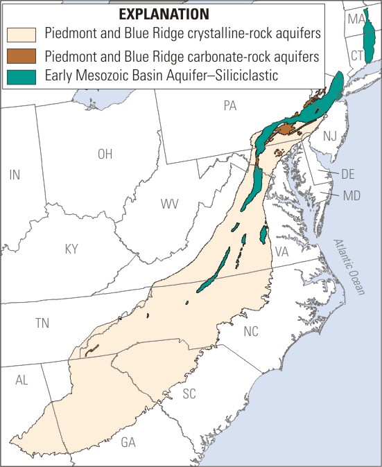
The Piedmont is topographically divided into uplands and lowlands. The uplands are primarily igneous and metamorphic rocks, hereafter termed crystalline aquifers, that are resistant to erosion and form the hilly terrain. The lowlands are made up of clastic sedimentary rocks and carbonate rocks. The Mesozoic Lowlands, hereafter termed siliciclastic aquifers, are made up of sandstones and shales and formed in a rift basin. The sandstones and shales are locally intruded by diabase. Limestone, dolomite, and marble of Paleozoic age form the carbonate aquifers. These three basic rock types (crystalline, siliciclastic, and carbonate) form the three basic units used to stratify the Piedmont. The crystalline rocks make up 92 percent of the land within the Piedmont (fig. 1). Siliciclastic and carbonate rocks are 7 and 1 percent of the Piedmont Physiographic Province, respectively. For the purposes of this report, the following abbreviations will be used to refer to these areas: Piedmont Crystalline, PCRY; Piedmont Carbonate, PCAR; Piedmont Siliciclastic, PSIL..
Crystalline Aquifers
The PCRY aquifers are made up of igneous and metamorphic bedrock predominantly composed of silicate minerals. These rocks range from coarse-grained gneisses and schists to fine-grained phyllites and metamorphosed volcanic rocks. The primary porosity of these formations is extremely small, and most ground water flow is in fractures in the bedrock (Trapp and Horn, 1997). A covering of weathered bedrock referred to as regolith overlies most of the PCRY aquifers and, because it commonly has a larger porosity than the crystalline bedrock, it is often an important factor in storage and movement of ground water. Bedrock that has weathered in place but maintains the structure of the original rock is referred to as saprolite. Saprolite develops in warm, humid conditions and therefore tends to be more significant in the southern part of the Piedmont.
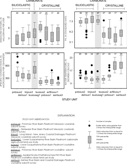
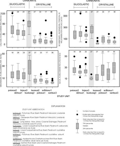
The PCRY aquifers are dominated by silicate weathering (Risser and Siwiec, 1996), which leads to lower specific conductance and low concentrations of dissolved solids, poorly buffered conditions with low pH, and low bicarbonate alkalinity (fig. 2). The pattern of silica concentrations in results from Cycle I sampling differs from the other major ions. Silica concentrations are lowest in PCAR aquifers and higher in both PSIL and PCRY aquifers (fig. 3).
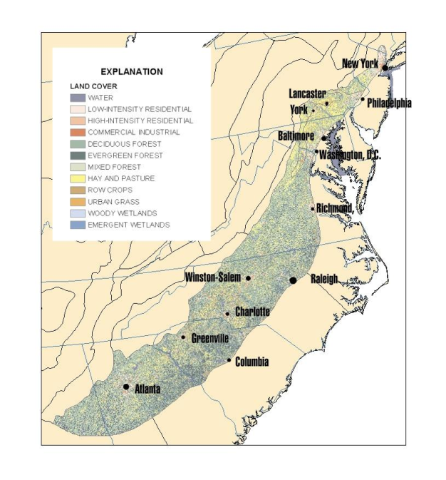
Population and Water Use – The population of the area underlain by the PCRY aquifers is approximately 16 million (all population and water use statistics cited are prorated based on percentage of county within the study area for border counties). Population and land use are closely related. The population density follows an expected pattern, with the most densely populated areas being in the vicinity of New York, Philadelphia, Baltimore, Washington, D.C., and Atlanta. These cities are generally not in the Piedmont, however the rapidly growing counties around these cities are located in the Piedmont. Other cities in or near the fringe of the Piedmont include Richmond, Virginia, the Winston-Salem, Charlotte, and Raleigh-Durham areas of North Carolina, as well as Greenville and Columbia, South Carolina (fig. 4). The overall population density of the PCRY aquifers area is the lowest of all of the areas, with about 200 persons per square mile.
Water used for public supply is primarily from surface water in the PCRY area, with only about 1 million residents (6 percent) relying on ground water for public supply. An additional 3.7 million (22 percent) rely on ground water for domestic self -supply. Overall, about 4.7 million people, or 28 percent of the population, rely on ground water in the PCRY aquifers. The total withdrawals from the PCRY aquifers are approximately 451 million gallons per day. The PCRY area has the lowest percentage of the population relying on ground water for public supply of the 3 aquifers in the Piedmont; however, an analysis of the percentage of the population relying on ground water shows the converse is true. Those rural areas that have a low population and low consumption rate for ground water typically are dependent on ground water for a high percentage of the water use. Ground water from public water supply dominates the usage statistics in urban areas and ground water from domestic self-supply dominates the usage in rural areas. Therefore, although ground water use is greatest in the more urban, northeastern, part of the Piedmont, ground water is an essential resource for the more rural parts of the Piedmont as well.
Land Use – Land use in the area underlain by the PCRY aquifers is variable. The region is characterized by a highly populated area (predominantly agricultural and urban land uses) in the northeast, with more rural and forested land use to the south (fig 4). Generally, the population density increases from rural forested to rural agricultural to suburban to urban. The most intense agricultural activity is in Pennsylvania, Maryland and Virginia, although agricultural activity is important throughout the Piedmont. The southern Piedmont includes more evergreen forests than the northern Piedmont.
Carbonate Aquifers
The PCAR aquifers of the PAS are located in the Piedmont Lowlands of Pennsylvania and Maryland. The limestone bedrock has typically weathered to an area of low relief. These aquifers are made up of mostly limestone and dolomite bedrock and are the most productive of the Piedmont aquifers (Trapp and Horn, 1997). Karst features can be a controlling factor in the movement of ground water and contaminants. Dissolution of limestone and dolomite bedrock can form sinkholes that channel surface water directly into the ground water system. Well-developed fractures, conduits, and even caves develop in the limestone and transport ground water and contaminants over long distances. Springs may develop as outlets to the ground-water systems.
The PCAR aquifers are significantly affected by carbonate weathering. This tends to lead to high specific conductance values and large concentrations of dissolved solids, high, well-buffered pH, and high bicarbonate alkalinity (fig. 2 and fig. 3). Because the carbonate aquifers are predominantly made up of limestone (calcium carbonate) and dolomite (calcium magnesium carbonate) water from these aquifers commonly do not have high dissolved silica concentrations. Calcium concentrations were typically highest in ground water from carbonate aquifers and lowest in all crystalline aquifers with the concentrations in the siliciclastic aquifers falling between the other two (fig.3). This pattern is indicative of the relative amounts of calcium carbonate available for weathering in these respective rock types. Magnesium is another major ion that shows this same pattern, for essentially the same reason.
Population and Water Use - The population of the area underlain by the PCAR aquifers is approximately 500,000. Population density is greater than in the PCRY area, with about 500 persons per square mile. The most densely populated areas are the cities of York and Lancaster in Pennsylvania. Water use for public supply is primarily from surface water in this area, with about 57,000 (12 percent) relying on ground water for public supply. An additional 155,000 (32 percent) rely on ground water for domestic self -supply. Overall, about 212,000 people, or 44 percent of the population, rely on ground water in the PCAR aquifer. Withdrawals of ground water from the PCAR aquifers total 24 million gallons per day.
Land Use - Agricultural land use is particularly high in areas underlain by the PCAR aquifers. The PCAR area is mantled by residual soil that supports some of the most intense agricultural activity in Pennsylvania (U.S. Department of Commerce, 1990). In some parts of the PCAR area, agricultural activity is being displaced by urban and suburban development.
Siliciclastic Aquifers
Siliciclastic aquifers are primarily in three major basins—the Newark Basin in New Jersey and Pennsylvania, the Gettysburg Basin of Pennsylvania and Maryland, and the Culpeper Basin of Virginia. The PSIL aquifers underlie the Piedmont Lowlands, which is relatively flat, undulating terrain. The siliciclastic aquifers are bounded by faults that formed basins that were filled with thick sequences of sedimentary rocks (thicknesses of Triassic and Jurassic rocks greater than 20,000 feet in the larger basins) of fluvial and alluvial origin (Trapp and Horn, 1997). The aquifers are made up of mostly sandstone and shale bedrock formed from silica sands and silicate clay minerals, respectively. The bedrock is often red or reddish-brown in color. The presence or absence of carbonate cement in the PSIL aquifers has a large affect on the concentrations of calcium and magnesium. Because the siliciclastic aquifers tend to contain both silicate minerals and carbonate minerals, they fall between the other two aquifer types (carbonate and crystalline) with regard to dissolved solids, specific conductance, pH, and bicarbonate alkalinity (fig.2 and fig. 3).
Population and Water Use - The population of the area underlain by the PSIL aquifers is approximately 5.5 million. The most densely populated parts of the PSIL are Central New Jersey, Southeastern Pennsylvania, Maryland, and Northern Virginia. Ground-water use from PSIL aquifers for public supply is more significant than that of the other two aquifers, with about 1.1 million (21 percent) relying on ground water for public supply. An additional 723,000 (13 percent) rely on ground water for domestic self -supply. Overall, nearly 2 million people, or 35 percent of the population, rely on the PSIL aquifer. Withdrawals of ground water from the PSIL aquifer total 218 million gallons per day. Ground-water pumping rates are highest in the PSIL aquifers, with about 7 times greater withdrawal rate in million gallons per day per square mile than the PCRY aquifers.
Land Use - Because much of this area is in the northern part of the Piedmont, the issue of urban and suburban development is significant. Agricultural land use is also significant in this area.
|
|