USGS Groundwater Information
Groundwater Resources Program
![[Photo: Ground water flowing out of well.]](http://water.usgs.gov/ogw/gwrp/images/flowingwell-vsm.jpg)
New & Noteworthy
USGS Groundwater WatchUSGS maintains a network of active wells to provide basic statistics about groundwater levels. ![[Image: USGS active water level wells location map.]](http://groundwaterwatch.usgs.gov/sm_ogw.png "USGS Groundwater Watch")
Other Water TopicsUSGS in Your StateUSGS Water Science Centers are located in each state. ![[Map: There is a USGS Water Science Center office in each State.]](/ogw/images/usmapsmall.gif)
|
Contents | Introduction | Importance of Ground Water to the Nation | Evolving Ground-Water Issues and USGS Programs | Relationship of GWRP to Other USGS Programs | Current Activities of the GWRP | Future Priorities for the GWRP | Concluding Remarks | STRATEGIC DIRECTIONS FOR THE U.S. GEOLOGICAL SURVEY GROUND-WATER RESOURCES PROGRAMA Report to CongressNovember 30, 1998EVOLVING GROUND-WATER ISSUES AND USGS PROGRAMS
Initial concerns about ground water in the United States were largely focused on development of the resource. As development intensified, issues such as overpumping, equitable sharing of ground-water resources, and degradation of ground-water quality became increasingly important. Further development led to wider recognition of the effects of ground-water withdrawals on surface water and on the biological resources associated with lakes, wetlands, riparian areas, and estuaries. Today, concerns about the sustainability of our ground-water resources involve:
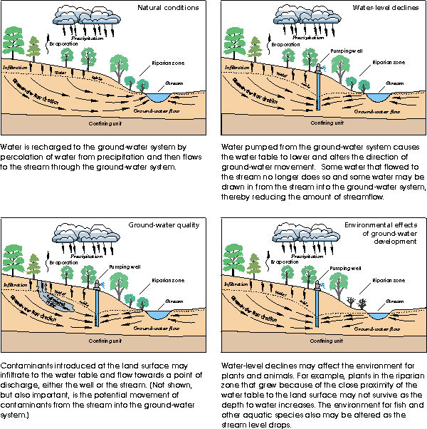
Thus, ensuring sustainable ground-water development depends not only on understanding subsurface processes in aquifers, but also understanding the interaction of ground water with land and surface-water resources (Figure 3).
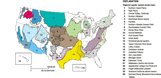
Figure 3. Diagram of a cross section of ground-water flow to a stream illustrating various effects of ground-water development. The USGS has continuously responded to changing ground-water issues. Four programs that should be mentioned in this regard are discussed here as background to their interplay with the Ground-Water Resources Program. The Regional Aquifer-System Analysis (RASA) Program began in response to the 1977 drought and recommendations by the U.S. National Water Commission and the U.S. Comptroller General. From 1978 to 1995, the RASA Program systematically evaluated 25 of the Nation's most important ground-water systems (Figure 4). Computer models were used to develop estimates of current and future water availability for many of these systems. In addition, a National Ground-Water Atlas was compiled as a general source of information on ground-water resources.
Figure 4. From 1978-95, the USGS intensively studied 25 regional aquifers as part of the Regional Aquifer-System Analysis (RASA) Program. The RASA Program provided a baseline of knowledge on the aquifer systems studied that will prove useful for many decades to come. However, as valuable as the RASA Program was, it leaves some important needs unfulfilled. The program did not examine many of the shallower or less productive aquifers that are very important to rural and small community water users and in sustaining flow in streams. The RASA Program also was static, describing the aquifers at a point in time. Virtually all of the information used in the RASA ground-water studies is now at least 10 to 20 years old. Ground water is dynamic, and aquifers must be re-examined over time as conditions and issues change. The National Water-Quality Assessment (NAWQA) Program was started in 1991 to provide information about the status and trends in the quality of the Nation's ground-water and surface-water resources. The focus of the ground-water component of the NAWQA Program has been on the effects of human activities on the quality of ground water in agricultural and urban areas. The NAWQA Program provides critical information on the overall status and trends in ground-water quality, but was never intended to evaluate issues such as ground-water depletion and saltwater intrusion, nor to address many complex issues associated with the interactions of ground water with streams, lakes, wetlands, and other surface-water bodies. The National Cooperative Geologic Mapping Program (NCGMP) was created as a partnership with State Geological Surveys and universities in 1992 by the National Geologic Mapping Act and reauthorized in 1997 as P.L. 105-36. Since 1992, the NCGMP has produced geologic maps and data bases as the framework for ground-water assessments of regional aquifers in the southwest and in the southeastern Coastal Plain and has funded many geologic mapping projects by State Geological Surveys and universities. On average, 35 percent of these projects cite ground-water issues as one of the principal reasons for mapping. For example, geologic map information for ground-water modeling, aquifer delineation, and wellhead protection was cited as the highest priority need by public and private-sector participants at the 1997 Great Lakes Geologic Mapping Forum in Indianapolis. The Federal-State Cooperative (Coop) Water Program matches funds from State and local agencies to support data collection and investigations that serve both federal interests and the needs of the State and local agencies. For over 100 years, this arrangement has been a valuable means to build a national data base and understanding of ground water. The RASA and NAWQA Programs have depended greatly on previous work in the Coop Program as the starting point to their efforts. A limitation of the Coop Program is that the studies rarely cross State lines because of the difficulty of aligning the funding plans of multiple States. A strength of the Coop Program is that close interaction with water managers at the State and local level ensures continuing relevance of the ground-water studies to address the most pressing issues. As new needs and issues emerge, the USGS works with its partners to provide the science to resolve them. Cooperators and other stakeholders responding to strategic-plan development by the USGS have strongly highlighted the importance of improved unbiased, long-term assessments of the quantity of water in the Nation's aquifers. They point out the importance of these assessments to economic development, to resolution of interstate conflict, and to resolution of conflicts between development and environmental protection. Interactions with the Western Water Policy Review Advisory Commission (WWPRAC) further highlighted the inadequacies of current assessments. Questions about the status and trends of ground-water resources were central to their ability to envision the future of water in the West. The data assessments the USGS could provide were not equal to the task, and the WWPRAC report expresses the need for assessments that look at large scales over time scales of many decades. |

![]() U.S. Department of the Interior |
U.S. Geological Survey
U.S. Department of the Interior |
U.S. Geological Survey
URL: http://water.usgs.gov/ogw/gwrp/stratdir/issues.html
Page Contact Information: Contact the Groundwater Resources Program
Page Last Modified: Tuesday, 03-Jan-2017 20:47:29 EST