USGS - science for a changing world

USGS Groundwater Information

Groundwater Resources Program

*  Home *  Regional GW Studies *  GW & Environment * Methods & Modeling *  Publications *  Data & Information [an error occurred while processing this directive] *  Intranet
 [Photo: Ground water flowing out of well.]

New & Noteworthy

* Press Release: Study Explores Groundwater and Geothermal Energy in Drought-Stricken Eastern Oregon and Neighboring States

* Technical Announcement: USGS Issues Revised Framework for Hydrogeology of Floridan Aquifer

* Press Release: High Plains Aquifer Groundwater Levels Continue to Decline

* Regional Groundwater Availability Study Geospatial Data

* Press Release: USGS Assesses Current Groundwater-Quality Conditions in the Williston Basin Oil Production Area

Past listings...

USGS Groundwater Watch

USGS maintains a network of active wells to provide basic statistics about groundwater levels.

 [Image: USGS active water level wells location map.]

Other Water Topics

*  Water Resources

*  Groundwater

*  Surface Water

*  Water Quality

*  Water Use

USGS in Your State

USGS Water Science Centers are located in each state.

 [Map: There is a USGS Water Science Center office in each State.] Washington Oregon California Idaho Nevada Montana Wyoming Utah Colorado Arizona New Mexico North Dakota South Dakota Nebraska Kansas Oklahoma Texas Minnesota Iowa Missouri Arkansas Louisiana Wisconsin Illinois Mississippi Michigan Indiana Ohio Kentucky Tennessee Alabama Pennsylvania West Virginia Georgia Florida Caribbean Alaska Hawaii and Pacific Islands New York Vermont New Hampshire Maine Massachusetts South Carolina North Carolina Rhode Island Virginia Connecticut New Jersey Maryland-Delaware-D.C.

Contents | Introduction | Importance of Ground Water to the Nation | Evolving Ground-Water Issues and USGS Programs | Relationship of GWRP to Other USGS Programs | Current Activities of the GWRP | Future Priorities for the GWRP | Concluding Remarks |


STRATEGIC DIRECTIONS FOR THE U.S. GEOLOGICAL SURVEY GROUND-WATER RESOURCES PROGRAM

A Report to Congress

November 30, 1998

CURRENT ACTIVITIES OF THE GROUND-WATER RESOURCES PROGRAM

Currently (1998), the Ground-Water Resources Program consists of five primary activities, briefly described below:

  1. Middle Rio Grande Basin, New Mexico.--Studies by the New Mexico Bureau of Mines and Mineral Resources and the USGS in cooperation with the City of Albuquerque have shown that ground water is not as plentiful as once thought. Work is underway by the USGS to improve the understanding and the accuracy of estimates of the quantities and distribution of water moving into and through the ground-water system of the entire Middle Rio Grande Basin.
  2. Southwestern United States.--Surface water in the southwestern United States is generally fully appropriated, and considerable ground-water development has taken place. New water supplies increasingly rely on conjunctive use of surface water and ground water. The dependence of sensitive ecosystems on ground water creates further competition for scarce water resources. To address these concerns, the USGS has begun a study of the interaction of ground water and surface water in the Southwest (Figure 5).
  3. South Florida.--Analysis of options for restoration of the Everglades and Florida Bay depends on improved understanding of ground water and its interactions with surface water. The U.S. Army Corps of Engineers, National Park Service, and South Florida Water Management District are using information from USGS studies as they move toward restoration plans for the Everglades.
  4. Atlantic Coast.--Development of ground-water resources along the Atlantic coast has caused saltwater to intrude many highly productive aquifers. Related concerns exist about the effects of changes in ground-water discharge to coastal ecosystems. A project to review what is known about these freshwater-saltwater issues along the Atlantic coast has recently begun.
  5. National Aquifer Data Base.--Preliminary planning is underway for a digital data base on principal aquifer systems as a follow-up to the National Ground-Water Atlas.

The Ground-Water Resources Program thus addresses a variety of information needs. As the program transitions from its exclusive focus on the 25RASA aquifer systems to broader issues, the above activities serve as prototypes for the possible future activities described below.

Availability of an adequate supply of freshwater is a significant issue affecting continued economic growth of cities and towns in the Southwest.

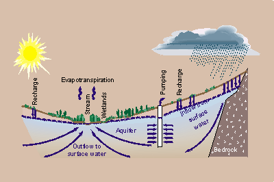
Figure 5. Availability of an adequate supply of freshwater is a significant issue affecting continued economic growth of cities and towns in the Southwest, which also contains of the most productive agricultural lands in the United States. Environmental considerations create increasing constraints on water development. For example, perennial streams, springs, and wetlands depend on ground-water discharge for their existence. In addition, the effect of climatic variability on water resources, particularly on ground-water recharge are not well understood and are a major deficiency in current models used in water management.

Accessibility FOIA Privacy Policies and Notices

Take Pride in America logo USA.gov logo U.S. Department of the Interior | U.S. Geological Survey
URL: http://water.usgs.gov/ogw/gwrp/stratdir/activities.html
Page Contact Information: Contact the Groundwater Resources Program
Page Last Modified: Tuesday, 03-Jan-2017 20:47:21 EST