|
|
A New Evaluation of the USGS Streamgaging Network--A Report to Congress
|
The Geospatial Data Infrastructure Over the past two decades, the USGS has continued to build the Nation's archives of digital spatial data. Some of the data sets used for this network analysis include: Traces of 60,000 stream segments which constitute a total of about 1 million kilometers of rivers. Boundaries of 329 river basins that cover the conterminous United States. These are subdivided into 2100 watersheds. Locations of 15 million people in areas at risk from riverine flooding. Locations of 18,000 streamgaging stations that have ever been operated by the USGS within the conterminous United States, of which 6,600 were in operation in 1996 (the current end-point of this analysis).
|
Another evaluation spanned the period 1983-88 and evaluated the utility of using less-costly alternative methods, such as hydrologic or statistical models, to provide the needed streamflow information, and analyzed the relationship between operating budgets and accuracy of the records. These earlier studies have formed the basis of a number of recent efforts in individual USGS Offices to better define a minimum streamgaging network for their States, including Iowa (Fischer, 1996), Maryland (Preston, 1997), Wisconsin (team for evaluating the Wisconsin water-monitoring network, 1998).
However, changes in technology, particularly the availability of geographic information systems (GIS) affords opportunities to examine networks in a different manner. Starting in March 1998 the USGS began a new approach to network evaluation, using the geospatial infrastructure of the national network of rivers and their watersheds. The streamgaging network analysis tool simulates the expert knowledge of hydrologists and applies it to a GIS data base to determine how well the network meets specified goals. What follows is a discussion of how well the streamgaging network meets important Federal goals. Although still a work in progress–many more enhancements are planned–the network analysis tool is sufficiently developed to provide a preliminary assessment of the network.
The technical details of how the network analysis tool operates are beyond the scope of this report. Simply stated, the tool uses GIS data to identify locations where streamflow information is needed to meet goals. Then, for each of these locations, it looks at the existing network of streamgaging stations and applies hydrologic expert rules to see if one or more stations provide the needed information. (An analysis of this type is, by its nature, only provisional. On-site conditions should always be checked before making a decision concerning a particular gage.) It tallies the met and unmet needs to give an overall measure of success in meeting goals.
 Larger image 235K, Gif format
|
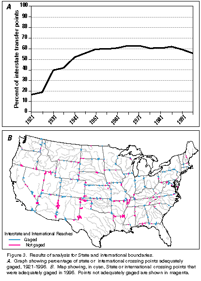
| Figure 3.–Results of analysis for State and international boundaries. A. Graph showing percentage of state or international crossing points adequately gaged, 1921-1996. B. Map showing, in cyan, State or international crossing points that were adequately gaged in 1996. Points not adequately gaged are shown in magenta. [D] |
The interstate and international transfers goal measures the ability of the network to provide accepted, neutral data for the States to use in the allocation of interstate waters. It requires computing amounts of water transferred across State lines or international borders. The metric was defined in the following manner: Every river reach that crosses a State line or international border and has a drainage area of at least 500 square miles at the crossing point was identified. There are 331 such reaches. The metric is the number of such crossing points that are considered "gaged."
As of 1996, 186 of these 331 crossing points were adequately gaged, for a 56-percent attainment of the goal (fig. 3). Overall, there has been relatively little change for three decades. Attainment of a full 100 percent coverage may not be an appropriate target level for this goal; some of the crossing points are on streams where there is little interstate conflict over the streamflow. Identification of the points not adequately gaged, however, will be useful information in the design discussions that are frequently held between the USGS and the States.
Larger image 233K, Gif format
|
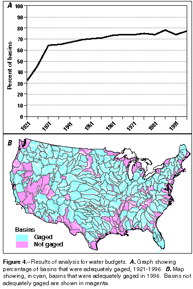
| Figure 4.–Results of analysis for water budgets. A. Graph showing percentage of basins that were adequately gaged, 1921-1996. B. Map showing, in cyan, basins that were adequately gaged in 1996. Basins not adequately gaged are shown in magenta. [D] |
The goal is to be able to account for the contribution of water from each major river basin to the next downstream basin or the ocean, estuary or the Great Lakes. Long-term, nationally-consistent data on the outflows of the major river basins plays a fundamental role in national water policies and planning. The metric is the number of basins that are adequately gaged out of the 329 basins that cover the conterminous United States.
Currently, 252 of the 329 basins (or 77 percent) are adequately gaged for
water budget accounting purposes (fig. 4). The gaps are almost
exclusively in smaller coastal basins and in arid regions where there may
be no basin outflow at all. In these basins, it is quite difficult to
attain adequate coverage because there is no single river that is the
outflow point, rather, there are a multitude of smaller streams that drain
the basin. Thus, fully 100 percent attainment of this metric is not
necessarily a realistic goal, but examination of the areas where it is not
achieved is warranted. Vigilance that current levels of attainment are not
lost is vital for preserving our ability to define the availability of
streamflow and to implement effective water policies.
|
Some feedback from users... "Your site has been the best source of river information we have ever been able to obtain to make rescue and evacuation decisions. ...Your work and site is much appreciated and invaluable to us!!! Thanks from the citizens in Hays County."—Emergency Management Official, Texas "This is not a request. It's a compliment. Congratulations on putting together an excellent and useful source of information on the web. I've used it a lot in the last few weeks. ... I have found that by checking the flows ... I can anticipate increases here and make necessary repairs to dikes and levees. My thanks to you."—Farmer, Texas "It is 4 AM in the morning. I am right in the middle of the flood on the Snake River. ... The water is now 3 inches to the top of my foundation. I just wanted to let you know that the information I can get off this web page has been invaluable. Thank you so much. No other source of information I can get has been as current or accurate as you wonderful people."—Homeowner, Idaho "FYI: Your hydrograph and station descriptions for the Neuse River Basin.. have been extremely helpful in our Emergency Management planning during the recent and continued flooding in Craven County. We now are able to predict when evacuations of low lying areas are needed and have on hand historical information to support our requests. Thank you, once again for your services." —Emergency Management Official, North Carolina
|
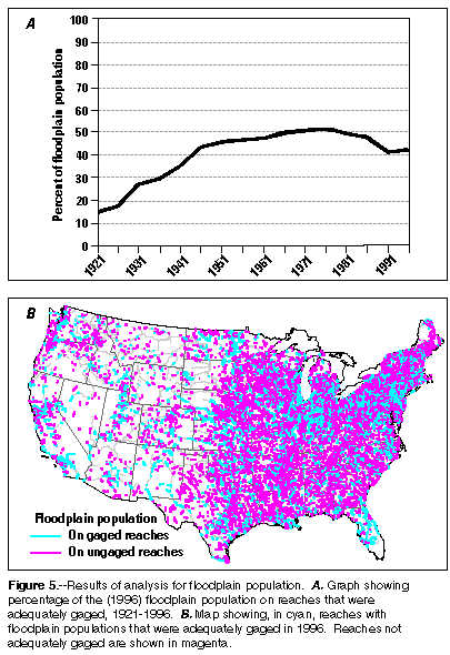
There are 18,000 communities that participate in the National Flood Insurance Program (NFIP), and the population at risk within these communities is about 15 million. The metric is the population living on the floodplain in these NFIP-participating communities, near reaches that are adequately gaged. Coverage of the population (fig. 5) is currently at about 42 percent and has declined from 51 percent in 1980.
 Larger image 234K, Gif format
|
| Figure 5.–Results of analysis for floodplain population. A. Graph showing percentage of the (1996) floodplain population on reaches that were adequately gaged, 1921-1996. B. Map showing, in cyan, reaches with floodplain populations that were adequately gaged in 1996. Reaches not adequately gaged are shown in magenta.[D] |
These results are much more problematic than those for the first two metrics. Recent history of flood losses in the Nation indicate that flood damages are not decreasing and that re-examination of flood risks may be needed (Western Governor's Association, 1997) given new knowledge of long-term climate variability, additional data collected in recent years, and the impacts of land-use changes on flood characteristics. In addition, streamgaging stations now have increased utility to communities at risk of flooding because of the real-time capability. Local governments, citizens, and businesses can monitor changing conditions at nearby and upstream gages and can rely on NWS forecasts and warnings based on the same real-time reports. This type of analysis can provide a basis for discussion with communities that may not be adequately covered by streamgaging stations at the present time.
 Larger image 235K, Gif format
|
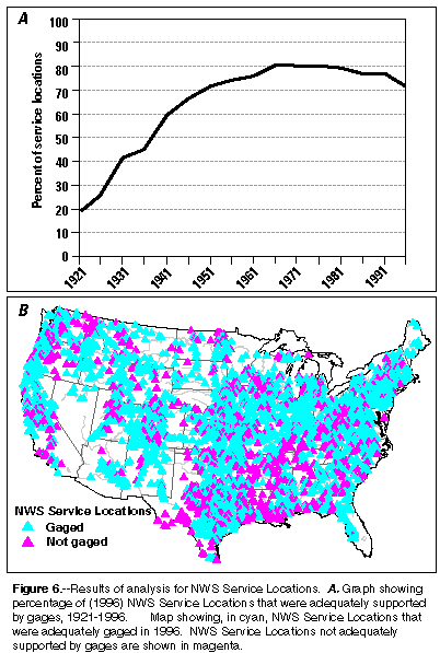
| Figure 6.–Results of analysis for NWS Service Locations. A. Graph showing percentage of (1996) NWS Service Locations that were adequately supported by gages, 1921-1996. B. Map showing, in cyan, NWS Service Locations that were adequately gaged in 1996. NWS Service Locations not adequately supported by gages are shown in magenta. [D] |
Streamflow records are used by the NWS to calibrate river forecasting models. NWS service locations are specific points on rivers for which the NWS delivers forecasts. The goal is to provide real-time water level and streamflow data at the 2,929 NWS service locations on rivers in the conterminous United States. (There are another 466 service locations located on reservoirs, where only stage is required.) Currently, the USGS provides streamflow data for 2,124 of these 2,929 locations or 73 percent of the total (fig. 6).
NWS figures show flood losses for the 50-year period, 1947-96, average $3.5 billion per year (constant 1997 dollars); average flood losses for the 5-year period, 1992-96, was $6.5 billion per year (National Weather Service, 1998). The gages are becoming increasingly useful in preventing losses (due to real-time capability), and yet the population served and forecast points served have been decreasing. The analysis provides the means to determine key locations where gages need to be placed or reactivated if money became available for meeting this goal. It also provides a basis for examining how stations could be deployed to better meet this goal while also enhancing (or at least not harming) the other Federal goals.
 Larger image 233K, Gif format
|
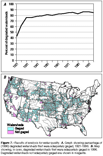
| Figure 7.–Results of analysis for water quality. A. Graph showing percentage of (1996) degraded watersheds that were adequately gaged, 1921-1996. B. Map showing, in cyan, degraded watersheds that were adequately gaged in 1996. Degraded watersheds not adequately gaged are shown in magenta. [D] |
The water-quality goal is to provide streamflow information to guide the efforts to improve water quality in those watersheds that are known to have degraded water quality. The Index of Watershed Indicators (IWI) published by the U.S. Environmental Protection Agency (EPA) in 1998, defined the watersheds determined by the States to have less than 50 percent of their assessed rivers that meet all designated uses (as established by the relevant State or tribal water-quality standards). The set of degraded watersheds is 677 out of a total of 2,079 possible watersheds in the conterminous United States.
The metric used is the number of these 677 watersheds which are adequately gaged. The metric relates only to the availability of the needed streamflow information and not to the water chemistry or biological data needs. Currently, the level of this metric is that 573 (85 percent) watersheds are adequately gaged. The percentage has continued to rise over time (fig. 7). The USGS will work with State agencies towards a more detailed, reach-by-reach definition suitable for evaluating specific locations known to be degraded and for which Total Maximum Daily Loads (TMDL) are going to be evaluated under the provisions of the Clean Water Act.
 Larger image 225K, Gif format
|
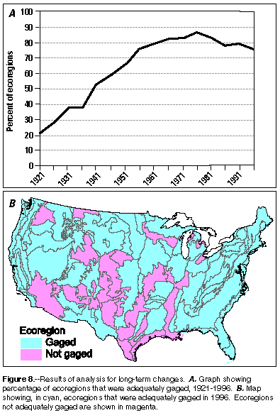
| Figure 8.–Results of analysis for long-term changes. A. Graph showing percentage of ecoregions that were adequately gaged, 1921-1996. B. Map showing, in cyan, ecoregions that were adequately gaged in 1996. Ecoregions not adequately gaged are shown in magenta. [D] |
The goal that is defined here is to monitor and characterize trends in streamflow in representative streams within each of the Nation's ecoregions. The ecoregions are used, rather than river basins, because they define areas of somewhat homogeneous landscape, elevation, climate and land cover, whereas river basins typically cut across many different natural regions. The term "representative streams" refers to streams whose watershed lies entirely within the ecoregion (as opposed to streams that may simply flow through the ecoregion). These representative streams are required to be free of significant regulation or diversion which can distort the results of any analysis of trends in streamflow. The metric is intended to focus on changes in streamflow that would result from changes in climate, changes in land-use practices, or changes in ground-water withdrawals. The metric is the number of ecoregions with a streamgaging station in at least 50 percent of the river basins in the ecoregion.
The results of this analysis show that the metric has declined from 86 percent at its peak in 1976 to a level of 76 percent in 1996 (fig. 8). Given the national concern over long-term environmental change, as driven by potential global climate change and regional land use change, this trend in the streamgaging network is a matter of significant concern.
 Larger image 106K, Gif format
|
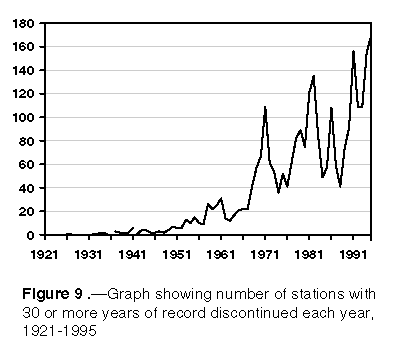
| Figure 9.–Graph showing number of stations with 30 or more years of record discontinued each year, 1921-1995. [D] |
Figure 9 shows the number of long-record stations that have been discontinued in each year since 1921. Up through 1965, the number was generally no more than about 20 per year (typically about 1 percent of the total number of long-record stations). Since then, there have been three periods during which discontinuation of stations has accelerated. The losses in the middle 1990's show about 4 percent of the long-record streamgaging stations being discontinued each year. Much of the loss of long-term stations in recent years is attributable to the need for funding agencies to support current-use stations instead of long-term stations and the inability of the USGS to fund those stations with solely Federal appropriations
Still another way to look at the issue of information availability for long-term analysis is to consider a special subset of all USGS streamgaging stations: the Hydroclimatic Data Network (HCDN). This network was defined in 1988 and described in Slack and Landwehr (1993) and Slack and others (1993). The stations in this network have certain very specific qualities. They have all been gaged at least 20 years, and are subject to little or no flow regulation or diversion. They all represent sites, that if gaged for a sufficiently long period of time, provide data that are valuable for the study of the relationships between climate, land-use, and streamflow.
 Larger image 233K, Gif format
|
| Figure 10.–A. Graph showing number of HCDN stations that were active, 1921-1996. B. Map showing, in cyan, HCDN stations active in 1996. HCDN stations inactive in 1996 are shown in magenta.[D] |
Figure 10 shows how the number of active HCDN stations in the network has changed over time. HCDN stations peaked in 1971 at 1,497 and has steadily declined since then to 1,161, a decrease of 22 percent. These declines are disturbing in terms of the potential for understanding long-term changes taking place in the environment.
|
The level of attainment of Federal goals typically rose steadily
through the 1960's or 1970's and then leveled off or declined.
|
Taking the Federal network goals together, we see a general pattern. In
most cases the level of attainment of the metrics, as measures of the
goals, typically rose steadily through the 1960's or 1970's and then have
either leveled off or declined. Some goals are now less well supported
than in the 1950's and 1960's. This raises concerns for two reasons. The
first is that the level of intensity of competition for the flow of the
Nation's rivers and streams has continued to increase while the level of
information about the resource is decreasing. The increased competition
reflects the many new demands that our society and our system of laws and
regulations are placing on the resources. A few decades ago the information
needs focused on withdrawal uses, navigation, hydropower production, and
flood risk estimation and flood mitigation projects. Today, it continues
to involve all of these needs, but the needs have expanded to include water
quality, aquatic and riparian habitat, and recreation. The second reason
for concern is that streamgaging stations have now become significantly
more useful through the use of modern technology. They not only fulfill
their long-term future uses but also fulfill important current uses by
providing real-time information needed to optimize water-resources
operations and to provide flood warnings. So, we have increasing demands
for information and yet the infrastructure to supply the information is
declining.
| Contents |
| Introduction | Purpose | Evaluation | Funding |
| Modernization | Future | Conclusions | References |
| USGS Home Page | USGS Water Resources |
U.S. Department of the Interior, U.S. Geological Survey