Water Resources of the United States


WATER DATA FOR THE NATION

National Water Information System

View current and historical streamflow, ground-water level, and water-quality data

Today's Water Conditions

View comparisons of current and historical conditions using maps
Click map to go to current water resources conditions in the U.S.

WATER SCIENCE SPECIALTIES

WATER SCIENCE BY STATE

USGS Water Science Centers are located in each state

Water Education Poster - Ground Water

Recharge Areas

illustration 
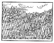
Recharge is the addition of water to the ground-water system. The recharge of freshwater begins as precipitation. Precipitation occurs in several forms, including rain, snow, and hail, but only rain is displayed on the poster. Some of the rain infiltrates into the soil. If the rate of the rainfall exceeds the rate of infiltration, surface water will flow over the land surface to surface-water bodies such as rivers and streams.
illustration 
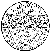
Water can infiltrate faster from the land surface into sandy soils than silty or clay soils. Water infiltrates into the soil and the unsaturated zone. The unsaturated zone occurs immediately below the land surface and contains both water and air in the pores and fractures in the rock materials. Water moves, or percolates, down through the unsaturated zone to the saturated zone. The saturated zone is where all the pores or fractures in rock materials are filled with water. The top of the saturated zone is called the water table.
illustration 
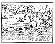
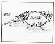
Because surface-water and ground-water systems are connected, surface water can recharge ground water. Aquifers can obtain water from such surface-water bodies as reservoirs and streams when and where the water table is lower than the surface-water body. Recharge areas usually are higher in elevation than discharge areas.

Discharge Areas

illustration Places where ground water flows from aquifers to springs, seeps, wetlands, ponds, or streams are called ground-water discharge areas. Ground-water discharge to these natural areas occurs when the water surface of the aquifer (water table on the poster) is at or above the elevation of the discharge area (river and pond on the poster). Surface-water and ground-water systems are interconnected. The flow of most streams is sustained by ground water seeping into the stream. The water surfaces of many ponds and wetlands are an extension of the local ground-water table. Springs occur where ground water flows from an aquifer to the land surface.
illustration Ground water can be brought to the land surface by pumping from a well. A well is an opening that has been drilled or dug into an aquifer below the water table. Water from the aquifer flows into this opening to replace water removed by pumping water from the well. The water table slopes from areas of recharge to discharge areas like rivers, ponds, wells, and springs.

previous page return to poster

USGS Home Core Science Ecosystems Energy and Minerals Environmental Health Land Resources Hazards Water

Accessibility FOIA Privacy Policies and Notices

U.S. Department of the Interior | U.S. Geological Survey

URL: https://water.usgs.gov/outreach/Posters/groundwater/grade_school/Page2.html

Page Contact Information: Water Webserver Team
Page Last Modified: Thursday, 01-Dec-2016 15:08:22 EST