

Water Education Poster - Ground Water
Ground water is water underground in saturated zones beneath the land surface. Contrary to popular belief, ground water does not form underground "rivers." It fills the pores and fractures in underground materials such as sand, gravel, and other rock. If ground water flows from rock materials or can be removed by pumping from the saturated rock materials in useful amounts, the rock materials are called aquifers. Ground water moves slowly, typically at rates of 7 to 60 centimeters per day in an aquifer. As a result, water could remain in an aquifer for hundreds or thousands of years. Ground water is the source of about 40 percent of water used for public supplies and about 38 percent of water used for agriculture in the United States.
One of the largest aquifers in the United States is the High Plains Aquifer. The aquifer is approximately the size of California and is located under parts of South Dakota, Wyoming, Kansas, Nebraska, Colorado, New Mexico, Oklahoma, and Texas. The High Plains Aquifer contains an estimated 4 quadrillion liters (4 with 15 zeros after it) of water.
This poster depicts an unconfined or water-table aquifer. An unconfined aquifer is an aquifer where the water surface - water table - is free to rise and decline as water moves from recharge areas to discharge areas. Recharge areas are places where an aquifer receives its water. The recharge sources shown are a reservoir, a stream, and precipitation. Their titles are red. The arrows represent the movement of water from the recharge sources to the discharge areas. The large circle on the right-hand side of the poster is a representation of how recharge occurs from precipitation.
The left-hand side of the poster shows conditions in a ground-water discharge area. Discharge areas are where ground water flows to the land surface or to surface-water bodies such as the pond and river shown on the poster. Ground water also can discharge by pumping a well. The titles of these ground-water discharges are yellow.
The poster is folded into 8.5" x 11" panels; front and back panels can easily be photocopied.
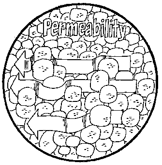 |
Permeability For water to move in an aquifer, the pores between rock materials and fractures in rock must be connected. If there is a good connection among pore spaces and fractures, water can move freely and we say that the rock is permeable. The capacity of rock material to transmit water is called permeability. Water moves through different materials at different rates - faster through gravel, slower through sand, and much slower through clay. Therefore, gravel is more permeable than sand, which is more permeable than clay. |
 |
 |