USGS Groundwater Information
|
USGS Groundwater Information > October 1, 2018 Highlights USGS Monthly Groundwater News and Highlights: October 1, 2018Feature: How Changes in Earth's Gravity Reveal Changes in Groundwater Storage![Conceptual diagram of gravity meter measurement [ Conceptual diagram of gravity meter measurement ]](images/feature/20181001_fs20183032fig.jpg)
Figure: As generalized in this image, a gravity measurement is sensitive to a cone-shaped region of the subsurface -- as depth increases, the sensitivity to individual water molecules decreases, but the region of sensitivity expands. Source: Kennedy, 2018. Figure is in the public domain. Changes in the amount of water stored in aquifers cause small changes in Earth's gravitational field. Since the 1980s, the USGS has developed field methods, software, and analytical procedures for using gravity data to aid in groundwater studies. When the amount of groundwater in an aquifer changes, either by recharge or by discharge to surface water or wells, the gravitational acceleration at the land surface also changes. This very small change is detectable with highly precise instruments. The measurements allow scientists to map changes in groundwater storage. Gravity changes can also be measured by satellites, which provide an average value of water-storage changes over several thousand square kilometers. While these data sources are complementary, land-based measurements provide finer spatial resolution at the local or regional scales that resource managers typically need to inform groundwater management and planning decisions. Learn more about the USGS's Southwest Gravity Program. USGS Groundwater-Related Technical AnnouncementsUSGS Seeks National Ground-Water Monitoring Network Proposals for 2019  
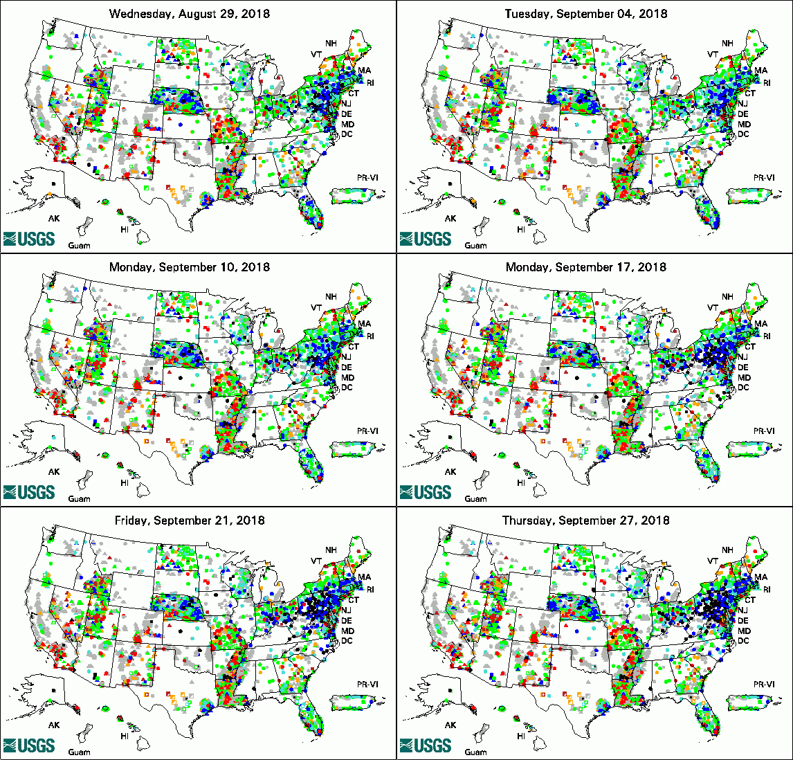
The USGS Active Groundwater Level Network includes about 20,000 wells that have been measured by the USGS or USGS cooperators at least once within the past 13 months. The animation shows a daily snapshot of water-level statistics in the network for September 2018. Credit: USGS. The image is in the public domain. USGS Groundwater-Related PublicationsWilliston Basin groundwater availability, United States and Canada (09/27/18) Groundwater availability of the Williston Basin, United States and Canada (09/28/18) Weathering of oil in a surficial aquifer (09/14/18) Continuing progress toward a national assessment of water availability and use (09/12/18) Changes in Earth's gravity reveal changes in groundwater storage (09/12/18) Selected trace-elements in alluvium and rocks, western Mojave Desert, southern California (09/10/18)
USGS Groundwater Flow and Transport Model Data ReleasesNote: The following links take you to data.doi.gov
Field Photos:In these photos, USGS Research Hydrologist Jeff Kennedy is making measurements of very small changes in the earth's gravity field to help us understand changes in groundwater storage. The yellow gravity meter in the top photo is an absolute-gravity meter, which provides a direct measurement of the absolute force of gravity at a location. The silver gravity meter in the second photo is a relative-gravity meter, which can measure small differences in gravity as the meter is moved from place to place. Archive of Past Highlights: |