USGS - science for a changing world

USGS Groundwater Information

*  Home *  Monthly Highlights *  Data & Information *  Publications *  Methods & Modeling *  Selected Topics *  Programs *  About *  Contact Us

USGS Groundwater Information > January 2, 2018 Highlights


USGS Monthly Groundwater News and Highlights: January 2, 2018

Subscribe and get the latest USGS groundwater news and science sent to your inbox every month!


Featured Product: Groundwater Quality in Four Principal Aquifers

 [ Map of location and summary of water quality in U.S. principal aquifers ]

Map of location and summary of water quality in U.S. principal aquifers. Source: USGS National Water Quality Program, 2017. Figure is in the public domain.


USGS recently completed studies of groundwater quality in four U.S. Principal Aquifers. Almost one-half of the Nation's population relies on groundwater for drinking water. Regional assessments of groundwater quality are part of ongoing USGS efforts to assess, understand, and forecast the quality of the Nation's groundwater. These studies provide resource managers and policy makers with needed information on which to base sound decisions for water management.


USGS Groundwater-Related Press Releases
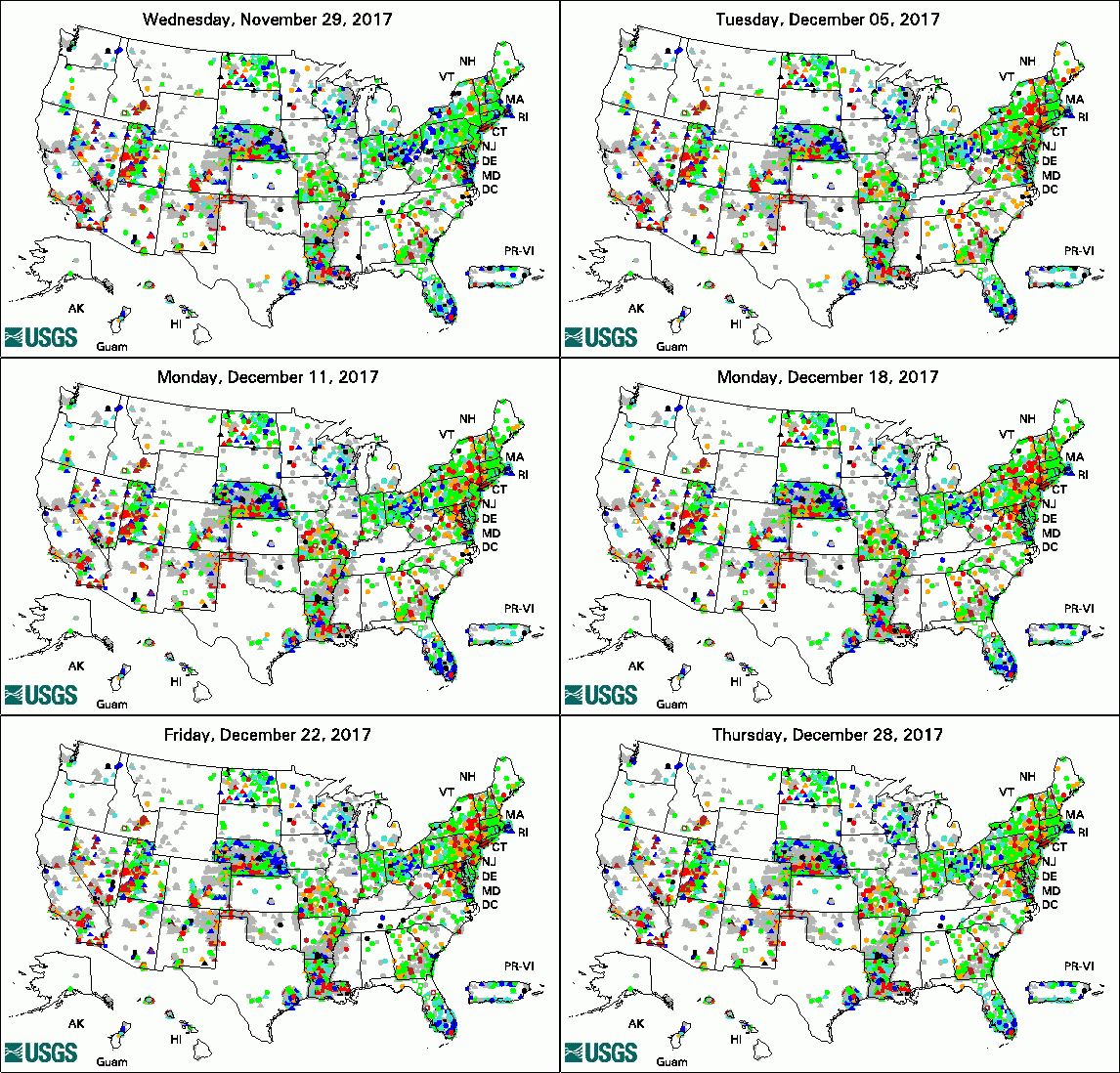
Animation of Groundwater Watch Active Water Level Network, 30 days
legend

The USGS Active Groundwater Level Network includes about 20,000 wells that have been measured by the USGS or USGS cooperators at least once within the past 13 months. The animation shows a daily snapshot of water-level statistics in the network for December 2017. Credit: USGS. The image is in the public domain.

Groundwater Quality in the Midwest: The Cambrian-Ordovician Aquifer System (12/7/2017)

Groundwater Quality in the North: The Glacial Aquifer System (12/7/2017)

Groundwater Quality in the Southwest: The Rio Grande Aquifer System (12/7/2017)

Groundwater Quality in the East: The Piedmont and Blue Ridge Crystalline-Rock Aquifers (12/7/2017)

The Quality of the Nation's Groundwater: Progress on a National Survey (12/7/2017)

Scientists Home in on Causes of High Radium Levels in Key Midwestern Aquifer (12/6/2017)


USGS Groundwater-Related Publications

Using enteric pathogens to assess sources of fecal contamination in the Silurian Dolomite Aquifer: Preliminary results (12/18/17)

Lead and strontium isotopes as monitors of anthropogenic contaminants in the surficial environment: Chapter 12 (12/11/17)

Environmental characteristics and utilization potential of metallurgical slag: Chapter 19 (12/11/17)

Baseline Assessment of Groundwater Quality in Pike County, Pennsylvania, 2015 (12/29/17)

Streamflow Distribution Maps for the Cannon River Drainage Basin, Southeast Minnesota, and the St. Louis River Drainage Basin, Northeast Minnesota (12/29/17)

Development of simulated groundwater-contributing areas to selected streams, ponds, coastal water bodies, and production wells in the Plymouth-Carver region and Cape Cod, Massachusetts (12/29/17)

Correlation between basalt flows and radiochemical and chemical constituents in selected wells in the southwestern part of the Idaho National Laboratory, Idaho (12/22/17)

Visualization of groundwater withdrawals (12/21/17)

Groundwater levels, geochemistry, and water budget of the Tsala Apopka Lake system, west-central Florida, 2004-12 (12/18/17)

Groundwater/surface-water interaction in central Sevier County, Tennessee, October 2015-2016 (12/14/17)

Generalized hydrogeologic framework and groundwater budget for a groundwater availability study for the glacial aquifer system of the United States (12/14/17)

Groundwater discharge to the Mississippi River and groundwater balances for the Interstate 94 Corridor surficial aquifer, Clearwater to Elk River, Minnesota, 2012-14 (12/13/17)

Sequence stratigraphy, seismic stratigraphy, and seismic structures of the lower intermediate confining unit and most of the Floridan aquifer system, Broward County, Florida (12/11/17)

Regional water table (2016) in the Mojave River and Morongo groundwater basins, southwestern Mojave Desert, California (12/08/17)

Groundwater, surface-water, and water-chemistry data, Black Mesa area, northeastern Arizona -- 2013-2015 (12/08/17)

Groundwater quality in the Rio Grande aquifer system, southwestern United States (12/07/17)

Groundwater quality in the glacial aquifer system, United States (12/07/17)

Groundwater quality in the Cambrian-Ordovician aquifer system, midwestern United States (12/07/17)

Groundwater quality in the Piedmont and Blue Ridge crystalline-rock aquifers, eastern United States (12/07/17)

Contaminant gradients in trees: Directional tree coring reveals boundaries of soil and soil-gas contamination with potential applications in vapor intrusion assessment (12/20/17)

Colloid mobilization and seasonal variability in a semiarid headwater stream (12/05/17)

Methane- and dissolved organic carbon-fueled microbial loop supports a tropical subterranean estuary ecosystem (12/12/17)

Water-resources and land-surface deformation evaluation studies at Fort Irwin National Training Center, Mojave Desert, California (12/15/17)

Vulnerability of coral reefs to bioerosion from land-based sources of pollution (12/11/17)

Groundwater model of the Great Basin carbonate and alluvial aquifer system version 3.0: Incorporating revisions in southwestern Utah and east central Nevada (12/04/17)

Water Quality, Sources of Nitrate, and Chemical Loadings in the Geronimo Creek and Plum Creek Watersheds, South-Central Texas, April 2015 - March 2016 (12/29/17)


USGS Groundwater-Related Software Updates and New Releases

  • FloPy v3.2.7: Python package for creating, running, and post-processing MODFLOW-based models


USGS Groundwater Flow and Transport Model Data Releases

Note: The following links take you to data.gov

MODFLOW-USG model of groundwater flow in the Wood River Valley aquifer system in Blaine County, Idaho

MODFLOW-2005 and MT3DMS models used to design and evaluate a bioremediation experiment at the former Naval Air Warfare Center, West Trenton, NJ


Field Photo

Did you know that groundwater flowing into lakes can affect the quality of the lake water? Periphyton, a type of algae, is growing on bottom sediment and rocks along nearshore areas of Lake Tahoe in California. The periphyton is seen as a nuisance and negatively impacts the recreational value of the lake. The USGS Nevada Water Science Center is working with the University of Nevada-Reno, in cooperation with the Lahontan Regional Control Board, to investigate the relationships between periphyton biomass, the lake, and shallow groundwater surrounding Ward Creek, near Tahoe City, California. This USGS study demonstrates the important role of groundwater in delivering nutrients to the periphyton communities during the winter-spring growth period.

In the first photo, hollow metal rods called piezometers installed in the lake bed are used to study lake and shallow groundwater conditions. The second photo shows diatoms attached to rocks along the west shore of Lake Tahoe.


 [ Photo of stream with science instruments in it. ]

Credit: USGS/ David Smith. Photo is in the public domain. Click on photo for larger version.


 [ Photo of stream with science instruments in it. ]

Credit: USGS/ David Smith. Photo is in the public domain. Click on photo for larger version.


Archive of Past Highlights:

Past monthly summaries are available online.


USGS Home Water Climate and Land Use Change Core Science Systems Ecosystems Energy and Minerals Environmental Health Natural Hazards

Accessibility FOIA Privacy Policies and Notices

USA.gov logo U.S. Department of the Interior | U.S. Geological Survey
URL: http://water.usgs.gov/ogw/highlights/2018-01-02.html
Page Contact Information: Contact the USGS Office of Groundwater
Page Last Modified: Tuesday, 02-Jan-2018 13:23:25 EST