Transport and Transformation of Nutrients in Channels and Floodplains
Project Personnel
Headwater Study Sites (Indiana)
(USGS HYPOXIA Program):
- J.K. Bohlke, USGS, Reston, VA
- Mary Voytek, USGS, Reston, VA
- Dick Smith, USGS, Boulder, CO
- Jud Harvey, USGS, Reston, VA
- Ron Antweiler, USGS, Boulder, CO
- Leslie Smith, U. Colorado, Boulder, CO
- Andy Laurson, Ryerson U., Toronto, Canada
- Craig Tobias, USGS, Reston, VA; now at UNC-W, Wilmington, NC
- Karen Casciotti, USGS, Reston, VA; now at WHOI, Woods Hole, MA
- Aaron Packman, Northwestern University, Chicago, IL
River/Floodplain Study Interactions (Louisiana):
- Jud Harvey, USGS, Reston, VA
- Greg Noe, USGS, Reston, VA
- Durelle Scott, USGS, Reston, VA; now at Virginia Tech
- J.K. Bohlke, USGS, Reston, VA
- Charley Demas, USGS, Baton Rouge, LA
- Dennis Demcheck, USGS, Baton Rouge, LA
HYPOXIA Project Description:
- Little is known about the in-stream processes that attenuate nitrogen in small and medium sized rivers, including tributaries of the Mississippi River, where it has been suggested that nitrogen loads are a key contributing factor in the development of a hypoxic zone in the Gulf of Mexico. One group of USGS researchers involved with the HYPOXIA program (R.L. Smith, J.K. Bohlke, M.A. Voytek, R. Antweiler, and J.W. Harvey) is engaged in a multidisciplinary investigation of denitrification and nitrification in two agriculturally impacted rivers in the Mississippi River basin (Iroquois River and Sugar Creek).
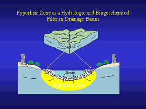
- The project is designed to sample transport in a Lagrangian (time of travel) scheme with a goal to determine the net effect of denitrification and nitrification on riverine nitrogen loads, nitrogen speciation, nitrogen isotope geochemistry, and trace constituent concentrations. The study uses depth- and width-integrated discharge measurements, estimates of nitrogen transport load, and in-stream tracer studies to characterize hydrologic transport and the extent of hyporheic exchange.
- The information obtained from the USGS study is providing one of the first comprehensive examinations of nitrification and denitrification in agriculturally impacted streams of the Mississippi River basin. Through application to regional nitrogen transport models, the study results are expected to facilitate an unprecedented evaluation of the role of in-stream processes in headwater basins in mitigating the transport of nitrogen to The Gulf of Mexico of the Mississippi drainage basin.

Current HYPOXIA Program Questions (Harvey, Bohlke, Voytek):
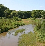
Streamwater flows easily through the relatively coarse stream bottom sediments at Sugar Creek, Indiana (2-mm median grain size), delivering streamwater nitrate to sites of potential denitrification as deep as 10 - 15 cm in the streambed. Can evidence be found for denitrification throughout the entire depth of the hyporheic zone, and is this 'deeper' component of flow and reaction in this environment important for reducing downstream nitrogen loads? What is the relative importance of hydrologic (stream velocity, grain size, and hydraulic conductivity of bed sediment) and biogeochemical factors (nitrate concentration, carbon quantity and quality, and redox potential in bed sediment) that affect the rate of denitrification in the streambed?
River/Floodplain Interactions Project Description:
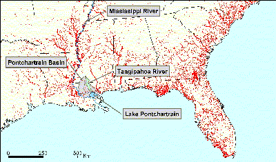
Fate of Nutrients on Floodplains of the Southeastern U.S. In the Southeastern United States, the river network contains active floodplain margins that regularly are inundated with flood water and its load of sediment and other materials during storm events. The movement of water and material onto floodplains serves to not only decrease and delay the peak discharge downstream, but also serves as an area for biogeochemical transformations. Our group is involved in examining the role of floodplains in reducing the downstream load of nutrients, specifically nitrogen species. We are currently studying floodplain dynamics in the Tangipahoa watershed that discharges into Lake Pontchartrain in Louisiana. Ongoing studies range from the centimeter to the regional scale, from examining denitrification and the flux of water in active sloughs to studying the cumulative role of floodplains within watersheds. Our work contributes to identifying the importance of riparian areas within stream networks, and the benefits provided by these regions to downstream water quality.

Woody wetland coverage (NLCD 1991) highlighting floodplain environments within the Southeastern United States (in red).

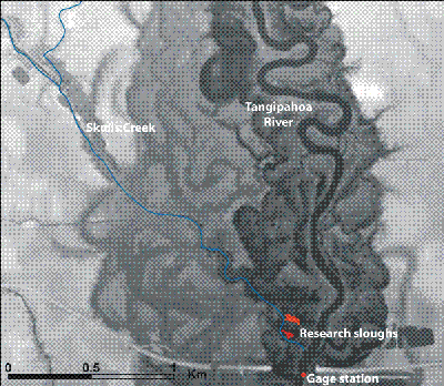
Lidar coverage of the lower Tangipahoa River near USGS gage. Research sloughs are inundated throughout the year (20% of the year on average) with water from the 2nd order Skulls Creek.
Links
Funding Acknowledgements:


