ModelMuse assigns values to data sets at nodes or elements in PHAST models using the following procedure.
1.First, a default value is assigned to every node or element by using either PHAST-style interpolation or mixtures (see "PHAST-Style Interpolation"), the selected interpolation method (see "Interpolation Methods"), or the default formula for the data set (see "Formulas" and "Data Sets dialog box").
2.Next, each object that affects the data set is processed, and nodes or elements that are intersected or enclosed by each object are assigned values on the basis of PHAST-style interpolation or mixtures or by using the object’s formula for the data set. Each object replaces values assigned previously by the default formula or by a previous object.
3.For a few data sets, the value may be further modified. For example, any negative values of Kx will be set to zero.
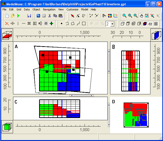
In PHAST, interpolation can be useful to specify the boundaries between geologic units (see example in fig. 4). To do this, the user first creates a data set for each interface between adjacent geologic units. Then the user creates point objects to specify the elevations of the interfaces at known locations. Interpolation can then be used to specify the elevations throughout the grid. These data sets for the elevations can then be used in the formulas for the upper and lower surfaces of “3-D Objects” that define properties of aquifers.
 |
Figure 4. Example of 2-D data sets used to define the top and bottom of a geologic unit in PHAST—(A) Top view, (B) Side view, (C) Front view, (D) Three-dimensional view. In the top view (A), point objects (black squares) were used to specify the top and bottom of a geologic unit by interpolation. Polygons were then used to define the value of the hydraulic conductivity of that unit. The colored cells represent the different values of hydraulic conductivity. Note the sloping surfaces of the geologic unit visible in the front (C) and side (B) views of the model. |
See also: