National Water-Quality Assessment (NAWQA) Program
Go to:
October 2004
These are the polygon coverages that represent the boundaries of the land use studies (LUS) and subunit surveys (SUS) that were conducted during cycle 1 of NAWQA. These do not include any coverages for cycle 2 studies.
Instructions on how to transfer the files are in the metadata under Distribution_Information.
GIS coverages of study unit LUS and SUS boundaries - October 2004:
Note: (February 27, 2008)
ACFBLUSFO1_BND, ACFBLUSFO1_TRG, CCPTLUSAG1A_TRG, and CCPTLUSAG1B_TRG have been replaced. The boundaries DID NOT change. For the ACFB coverages, the SUCODE was changed from acfbreffo3 to acfblusfo1. For the CCPT coverages, the STAID item was dropped from the .pat files.
Note: (June 21, 2006)
DLMVLUSCR1_TRG and WMICLUSAG2_TRG have been replaced. The boundaries DID NOT change. However, the NULL polygon in each coverage was changed so that SUCODE = ' ' and INSIDE = 0.
Note: (June 22, 2005)
SANTLUSRC1_BND has been replaced. The boundary should be the same as SANTSUS1_BND, not the same as SANTSUS2_BND.
Maps of cycle 1 ground water study areas (9.6mb PDF file): The PDF file contains one page size map per network, sorted by study unit. Each map shows BND, TRG if applicable, and wells. Maps were generated at various dates from 2002-2004 so some might not reflect the wells in the current data base. Also, no distinction is made between cycle 1 wells and cycle 2 wells.
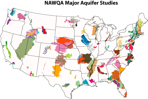
Map of NAWQA Major Aquifer Studies (Feb. 2005):

 U.S. Department of the Interior |
U.S. Geological Survey
[an error occurred while processing this directive]
URL: http://water.usgs.gov
Page Contact Information: Carise Barbour
Page Last Modified: Tuesday, 20-Oct-2009 16:04:44 EDT
