U.S. Geological Survey
National Water-Quality Assessment Program

USGS Internal Access Only

About the Aquifer Planning Data Analysis Reports

Glacial Aquifer System
Status and Trends

Public PA page || Public GLAC page

About the Aquifer

Large continental glaciers covered parts of Canada and the northern United States between approximately 1.6 million and 10,000 years ago. These glaciers left behind a blanket of sand, gravel, and clay deposits ranging in thickness from less than 1 foot (ft) to over 1,000 ft. These deposits often are the major drinking-water supply in this part of the United States and Canada.

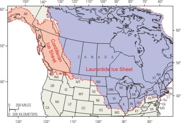
The glacial aquifer is naturally divided by the two ice sheets that once covered the area: the Cordilleran and the Laurentide. The northwest-trending Cordilleran ice sheet generally covered the area west of the Rocky Mountains from extreme northern Washington through western Canada and into southern Alaska. The Laurentide ice sheet generally covered Canada east of the Rocky Mountains and parts or all of the northern United States from Maine to Montana.

Bibliography

Hydrogeology of the Glacial Aquifer -- Ground Water Atlas of the United States

Planning

Regional Framework

Water-Quality Issues

Workplan Draft (PDF Format--size 13MB)

Conference Call and Meeting Minutes

Glacial Group 5-yr Plan 2008-13 (PDF 1 Mb)

Circular Planning

Key Reports for Circular (Excel 1 Mb)

Glacial Circular Workgroup Meeting (Nov. 18-20, 2009)

Draft Circular Chapter 2 : Background

Proposals

Assessment of arsenic occurrence and distribution in Maine -- Draft, developed by MeWSC and under discussion

Reports

Report Plans: description of planned reports

Presentations

Abstracts

Publications

Figures for use in Glacial Aquifer System Reports

Report Cover Template (CS2 format | CS3 format)

Internal Communication:

Report Webinars

Report Summary Two-pagers:

External Communication:

Glacial Aquifer System Calling Card (PDF, 591Kb)

Data

Field parameter, major ion, trace element, and nutrient data for analysis of the Glacial Principal Aquifer (data updated 09-16-2005). Metadata about this dataset (updated 09-16-2005)

VOC, radionuclide, stable isotope, dissolved organic carbon data for analysis of the Glacial Principal Aquifer (05-20-2005). Metadata about this dataset (updated 09-16-2005)

Pesticide data for analysis of the Glacial Principal Aquifer (05-20-2005). Metadata about this dataset (updated 09-16-2005)

Detailed well info including primary water use, well depth, open interval top and bottom, casing diameter, lithology, water level, specific capacity, drawdown, discharge, discharge method, water level produced, depth to top and bottom of lithologic unit, and lithologic unit ID for analysis of the Glacial Principal Aquifer (05-20-2005). Metadata about this dataset

Analysis

Summary of how censored, missing, and estimated data was treated

Interactive Maps for Display and Analysis

Piper diagrams by SUID (PDF format)

Results from preliminary analysis of Cycle I NAWQA data

For more information, please contact:

Kelly Warner, Hydrologist,
Glacial Aquifer
(217) 328-9739
klwarner@usgs.gov

Go to the NAWQA Ground-Water Synthesis by Principal Aquifer Home Page