
U.S. Geological Survey
National Water-Quality Assessment Program
USGS Internal Access Only
Regional Framework
 |
|
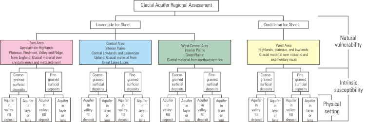
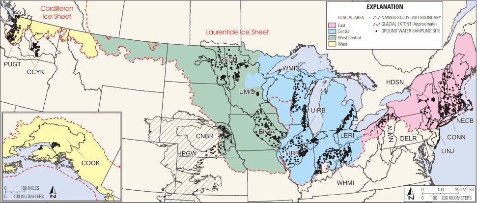 The glaciated area was divided into four major glacial regions based on differing source material--East, Central, West Central, and West. The purpose of dividing the glacial aquifer by source material is to have an indication of the natural water quality. Numerous studies have been done on glacial sediments that show distinct geochemical differences in the sediment based on source area and sediment size (Randall, 2001; Shilts, 1995; Shilts, 1993; Shacklette and Boerngen, 1984). Weathering and leaching can dissolve and mobilize many constituents from the sediments that will affect the natural ground-water chemistry. Changes in aquifer conditions, such as redox, may begin to mobilize chemicals within or absorbed to the source materials, and thus, continue to alter the natural ground-water chemistry.
The first division based on source material was defined by the extent of the two ice sheets; this division separates the West region (defined by the Cordilleran ice sheet) from the other regions (defined by the Laurentide ice sheet). The remaining divisions were made by Physiography (Fenneman and Johnson, 1946). The physiographic map by Fenneman and Johnson (1946) represents distinctive areas having common topography, rock types and structure, and geologic and geomorphic history that are all factors affecting the origin of glacial materials. Combining the physiography map of Fenneman and Johnson (1946) with the boundaries of glacial lobes and sublobes as defined by Mickelson and others (1983) was the basis for the division of source material into East, Central, and West Central regions. The division of East and Central is the boundary between the Central Till Plains and the Appalachian Plateau (Fenneman and Johnson, 1946) in north-central Ohio. Mickelson and others (1983) have a similar distinction except the northern deposits near the Great Lakes are included in the same region as the Till Plains. The division between Central and West Central is based on the boundary between the Central Till Plains and the Western Lake deposits or Dissected Till Plains. This boundary follows the Mississippi River to Minneapolis, MN and then north of Minneapolis. The boundary is modified to more accurately represent the glacial lobe sources defined by Mickelson and others (1983). These boundaries are general guidelines for comparing water quality across the glaciated area, but local detail on source of glacial material may further refine this division.
The glaciated area also was divided into two types of surficial deposits--coarse- or fine-grained. The purpose of dividing the glacial aquifer by surficial deposits is to have an indication of the vulnerability of surficial or underlying aquifers to anthropogenic contamination. Numerous studies have been done on glacial sediments that determine differences in the vulnerability based on material and texture (Arnold and Friedel, 2000; Wolock, D.M. and others, 2001; Berg and others, 1984). The property of sediments that describes the relative ease of water movement through the sediments is hydraulic conductivity--a major factor in the rate of ground water and contaminant movement. Hydraulic conductivities can be orders of magnitude different between fine-grained clays and coarse-grained sands (table 1). Overlapping conductivities result for these materials similar to the overlapping textural ranges for the glacial sediments.
| Geologic Material | Hydraulic Conductivity, in cm/sec |
Comments |
|---|---|---|
| clean sand and gravel | 1x10⁻³ | May be highly permeable. |
| fine sand and silty sand | 1x10⁻⁵ to 1x10⁻³ | |
| silt (loess, colluvium, etc.) | 1x10⁻⁶ to 1x10⁻⁴ | |
| gravelly till, less than 10% clay | 1x10⁻⁷ to 1x10⁻⁵ | Often contains gravel/sand lenses or zones. |
| till, less than 25% clay | 1x10⁻⁸ to 1x10⁻⁶ | Often contains gravel/sand lenses or zones. |
| clayey till, greater than 25% clay | 1x10⁻⁹ to 1x10⁻⁷ | Often contains gravel/sand lenses or zones. |
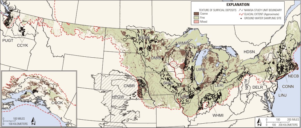 The spatial distribution of fine- and coarse-grained stratified drift is derived from the digital coverage by Soller (1998). Coarse-grained stratified drift is defined by Soller (1998) for the glacial materials as consisting of layered sand and gravel, with less common silt and clay beds, deposited in fluvial, glaciofluvial, deltaic, and outwash-plain settings. Holocene alluvium also has been included in this unit although it is silty or clayey in places, and may overlie glacial sand and gravel. The fine-grained stratified drift generally is clay, silt, and very fine sand, but includes lesser amounts of coarser material, commonly as interbeds (Soller, 1998). Till consists of poorly sorted sediments that are unstratified and composed of particles ranging in size from clay to large boulders. The glacial framework described in this workplan includes fine-grained stratified sediments and till to represent fine-grained material. Although there is a wide range of till hydraulic conductivity, considering the till as fine-grained material (10-12 to10-6 m/s) is supported in Freeze and Cherry (1979).
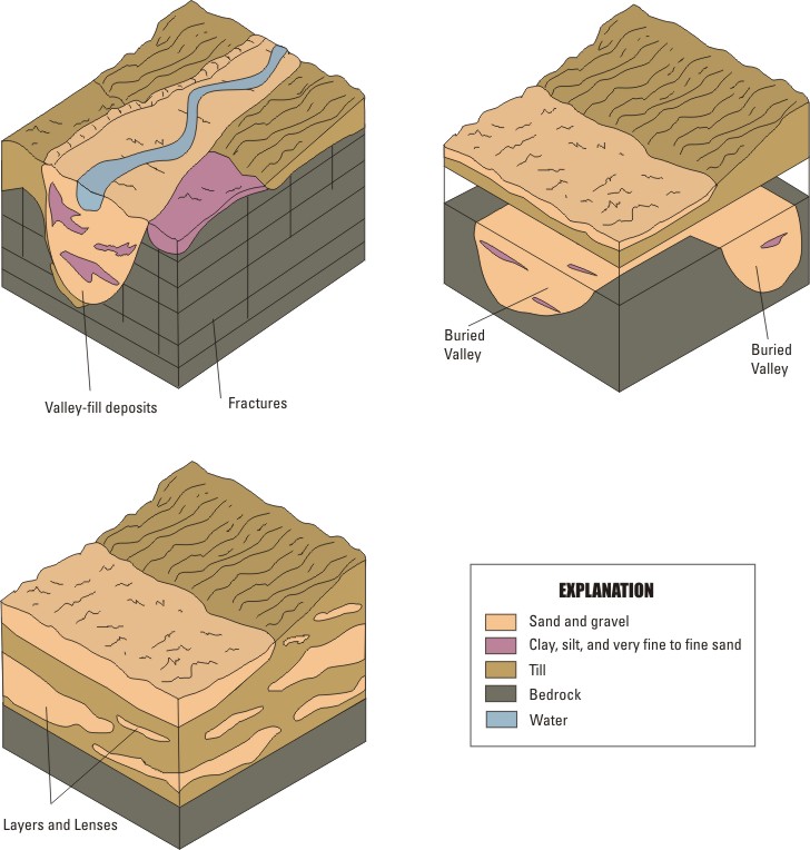 The glaciated area also was divided into 2 general patterns of aquifer geometry--valley-fill deposits and layers, or lenses. The purpose of dividing the glacial aquifers by aquifer geometry is to indicate distribution and connectivity of aquifer material. An understanding of the three-dimensional configuration and aquifer boundaries is a prerequisite to development and protection of the aquifers. Randall (2001) summarizes the need to know aquifer geometry in conjunction with surficial material: The distribution of stratified-drift aquifers is not coincident with the surficial distribution of coarse-grained stratified drift. For example, some coarse deposits constitute productive aquifers but are buried beneath fine-grained deposits and thus are not depicted on surficial geology or soils maps; other deposits are surficial but useless as aquifers because they rest on shallow bedrock and are thinly or variably saturated...the interpretation of [site specific] information depends much on what patterns the aquifer geometry the investigator expects or recognizes as it does on the information itself (p. B15).
Aquifer geometry is difficult to determine in layers and lenses, but the boundaries of an aquifer within a bedrock valley are more readily discerned. Most valley-fill aquifers in the northeastern United States (East region) are composed of stratified drift that is in connection to the land surface and bounded by bedrock. Some stratified valley-fill aquifers in the northeast contain surficial confining units, but this is not common. The valley-fill aquifers in the Central region often are buried beneath a thick sequence of fine-grained till and bounded by carbonate bedrock (for example, the Mahomet Aquifer in Illinois and buried-valley aquifer near Dayton (Rowe, 1999)), but there are many valley-fill aquifers in river valleys that are connected to the land surface (for example, the valley-fill aquifer near Indianapolis and Mahomet-Sankoty aquifer near Peoria).
A map showing the third layer of the stratification framework is under development. A composite map showing buried valleys across the glaciated region of the United States is not available and, therefore, one would have to be compiled.

