National Water Census
Water Use Science. Humans have had a profound effect on the hydrologic cycle throughout the post-development era. We change the run-off characteristics of the landscape, we affect how much water evaporates to the atmosphere, and we consume water and transfer it to other watersheds before it is returned to the environment.Understanding man’s use of water and how man moves water on the landscape is the science of water use. This strategy will focus significant resources to better understanding and quantifying water use in the Nation and to apply statistical rigor to the information that we use.
Water use will be estimated by 1) integrating national, state, and private databases of population, housing, climatological, agricultural, and economic information; 2) developing statistical relations between these data sets and metered withdrawal and delivery data for users across the region; and 3) using these relations to estimate water use (demand) across the region by small geographic areas. Many partners in all levels of government, industry, agriculture, water purveyors, and interest groups have much knowledge to share in this arena and the USGS will develop means to incorporate this information. Read more about water use in the United States.
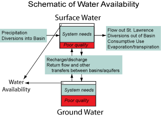 Hydrologic Indicators. Hydrologic indicators represent the basic building blocks of the water cycle. Understanding water availability is based on obtaining information about, and understanding the trends in, these indicators. The USGS will work to systematically produce information on:
The delivery of this information must be timely and in a form that can be easily used by resource managers. It will be the goal of the USGS to provide this information at scales defined by the end user. We will strive to provide much of this information in a “point and click” environment, where the user identifies the point in the watershed that they are interested in, has a basin-boundary automatically delineated, and then gains access to the relevant hydrologic indicators and trends within that boundary.
Focused Studies. Throughout our country, there are areas where competition for water resources has reached a level of national attention and concern. Sometimes the competing interests are multiple human needs – needs for potable water, for irrigation, for energy, for industrial processes or for other uses. In other circumstances, the competition is between human needs and aquatic ecosystems needs. The nation needs an assessment of these areas which comprehensively examines all of the hydrologic and biologic aspects of water availability. USGS is proposing a series of studies, focused on selected watersheds, where there is a desire on the part of watershed stakeholders to conduct a comprehensive technical assessment of water availability with the best available tools. The USGS would work collaboratively with watershed stakeholders and the various agencies involved to scope and conduct these studies.
Cooperation with other Agencies and Stakeholders. There are many opportunities to strengthen our understanding of water availability information through integration of national, regional and state datasets. The USGS will reach out to other Federal, state and regional agencies to make those linkages. This is particularly true within agencies involved in environmental regulation, water allocation, water infrastructure, agriculture, energy, climatology and meteorology, as well as entities that maintain databases on commercial and industrial applications. The USGS will also be working over the coming months with stakeholders to further develop this implementation plan. The USGS wants to hear about information useful to the assessment process, what kinds of products are most desirable for resource management agencies and what may help increase public understanding of water availability as a societal issue.
![]() U.S. Department of the Interior |
U.S. Geological Survey
U.S. Department of the Interior |
U.S. Geological Survey
URL: https://water.usgs.gov/wsi/elements.html
[an error occurred while processing this directive]
Page Contact Information: (none)
Page Last Modified: Thursday, 04-Jun-2009 15:27:43 EDT
URL: https://water.usgs.gov/wsi/elements.html
Page Contact Information: NatWeb Team (GS_Help_Natweb@usgs.gov)
Page Last Modified: Thursday, 04-Jun-2009 15:27:43 EDT

