USGS - science for a changing world

USGS Groundwater Information

*  Home *  Monthly Highlights *  Data & Information *  Publications *  Methods & Modeling *  Selected Topics *  Programs *  About *  Contact Us *  OGW Intranet

USGS Groundwater Information > September 01, 2017 Highlights


USGS Monthly Groundwater News and Highlights: September 01, 2017

Subscribe and get the latest USGS groundwater news and science sent to your inbox every month!


Featured Product: MODFLOW 6 -- USGS Modular Hydrologic Model

MODFLOW 6, the newest version of the world's most widely used groundwater modeling software, is now available for download from the USGS. Redesigned to improve user experience and accommodate future features, MODFLOW 6 introduces a model coupling framework to the program that, for more than 30 years, has been used by academics, private consultants, and government scientists to accurately, reliably, and efficiently simulate groundwater flow. This updated core version of MODFLOW was redesigned from the ground up to incorporate many of the new advances in groundwater modeling developed over the past decade. The MODFLOW 6 software and user guides are available for download.


USGS Groundwater-Related Publications

Animation of Groundwater Watch Active Water Level Network, 30 days
legend

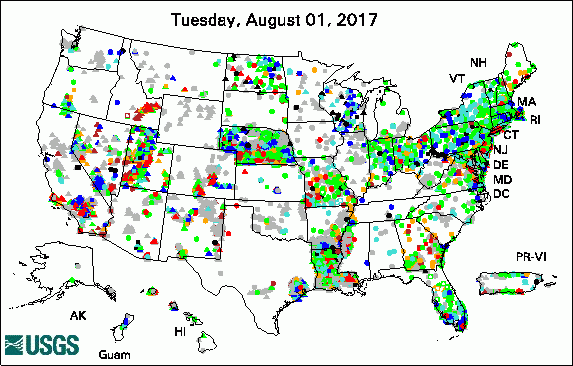
The USGS Active Groundwater Level Network includes about 20,000 wells that have been measured by the USGS or USGS cooperators at least once within the past 13 months. The animation shows a daily snapshot of water-level statistics in the network for August 2017. Credit: USGS. The image is in the public domain.

Predicting redox-sensitive contaminant concentrations in groundwater using random forest classification (08/29/17)

A large-scale environmental flow experiment for riparian restoration in the Colorado River delta (08/29/17)

Integrating active restoration with environmental flows to improve native riparian tree establishment in the Colorado River Delta (08/29/17)

Salish Kootenai College and U.S. Geological Survey partnership -- Enhancing student opportunities and professional development (08/30/17)

Water resources of Parowan Valley, Iron County, Utah (08/29/17)

Groundwater discharge by evapotranspiration, flow of water in unsaturated soil, and stable isotope water sourcing in areas of sparse vegetation, Amargosa Desert, Nye County, Nevada (08/30/17)

A process to estimate net infiltration using a site-scale water-budget approach, Rainier Mesa, Nevada National Security Site, Nevada, 2002-05 (08/30/17)

Geochemical and hydrologic factors controlling subsurface transport of poly- and perfluoroalkyl substances, Cape Cod, Massachusetts (08/28/17)

Delineation of salt water intrusion through use of electromagnetic-induction logging: A case study in Southern Manhattan Island, New York (08/24/17)

The Tule Springs local fauna: Rancholabrean vertebrates from the Las Vegas Formation, Nevada (08/21/17)

Water-level altitudes 2017 and water-level changes in the Chicot, Evangeline, and Jasper Aquifers and compaction 1973-2016 in the Chicot and Evangeline Aquifers, Houston-Galveston region, Texas (08/17/17)

Agricultural irrigated land-use inventory for Polk County, Florida, 2016 (08/17/17)

Field-trip guide to mafic volcanism of the Cascade Range in Central Oregon -- A volcanic, tectonic, hydrologic, and geomorphic journey (08/28/17)

Detecting temporal change in land-surface altitude using robotic land-surveying techniques and geographic information system applications at an earthen dam site in Southern Westchester County, New York (08/21/17)

Land subsidence and recovery in the Albuquerque Basin, New Mexico, 1993-2014 (08/14/17)

Changes in projected spatial and seasonal groundwater recharge in the upper Colorado River Basin (08/15/17)

Comparison of sediment and nutrient export and runoff characteristics from watersheds with centralized versus distributed stormwater management (08/11/17)

Documentation for the MODFLOW 6 Groundwater Flow Model (08/28/17)

Documentation for the "XT3D" option in the Node Property Flow (NPF) Package of MODFLOW 6 (08/28/17)

Documentation for the MODFLOW 6 framework (08/28/17)

Estimation of low-flow statistics at ungaged sites on streams in the Lower Hudson River Basin, New York, from data in geographic information systems (08/02/17)

Porosity and pore size distribution in a sedimentary rock: Implications for the distribution of chlorinated solvents (08/01/17)

Spatial heterogeneity of within-stream methane concentrations (08/01/17)

Future research needs involving pathogens in groundwater (08/01/17)

Temporal changes in nitrogen and phosphorus concentrations with comparisons to conservation practices and agricultural activities in the Lower Grand River, Missouri and Iowa, and selected watersheds, 1969-2015 (08/02/17)

Geochemical characterization of groundwater discharging from springs north of the Grand Canyon, Arizona, 2009-2016 (08/02/17)

Simulated groundwater flow paths, travel time, and advective transport of nitrogen in the Kirkwood-Cohansey aquifer system, Barnegat Bay-Little Egg Harbor Watershed, New Jersey (08/01/17)


USGS Groundwater-Related Software Updates and New Releases


USGS Groundwater Flow and Transport Model Data Releases

Note: The following links take you to data.gov

GWM-2005, MODFLOW-2005, MODFLOW-NWT, and SEAWAT-2000 groundwater flow models of the Bedrock Aquifers at the Kettle Moraine Springs State Fish Hatchery, Sheboygan County, Wisconsin

MODPATH particle-tracking analysis of groundwater flow and travel times to the Barnegat Bay-Little Egg Harbor estuary and streams within the Barnegat Bay-Little Egg Harbor watershed, New Jersey


Field Photo

USGS collects groundwater data across the Nation. In order to provide consistent, high-quality, reliable data, we use standardized field methods and procedures. In this photo, hydrologists and hydrologic technicians from USGS Water Science Centers participated in an August 2017 class on USGS groundwater field methods. Kim Cesal of the USGS Washington Water Science Center is demonstrating proper site visit and groundwater-level measurement methods. Interested in learning more? USGS groundwater technical procedures and demonstration videos are available online.


 [ Photo: Scientist operates equipment in the filed. ]

Credit: USGS. Photo is in the public domain. Click on photo for larger version.


Archive of Past Highlights:

Past monthly summaries are available online.


USGS Home Water Climate and Land Use Change Core Science Systems Ecosystems Energy and Minerals Environmental Health Natural Hazards

Accessibility FOIA Privacy Policies and Notices

USA.gov logo U.S. Department of the Interior | U.S. Geological Survey
URL: http://water.usgs.gov/ogw/highlights/2017-09-01.html
Page Contact Information: Contact the USGS Office of Groundwater
Page Last Modified: Tuesday, 05-Sep-2017 13:37:16 EDT