USGS Groundwater Information
Groundwater Resources Program
![[Photo: Groundwater flowing out of well.]](/ogw/gwrp/images/flowingwell-vsm.jpg)
New & Noteworthy
USGS Groundwater WatchUSGS maintains a network of active wells to provide basic statistics about groundwater levels. ![[Image: USGS active water level wells location map.]](http://groundwaterwatch.usgs.gov/sm_ogw.png "USGS Groundwater Watch")
Other Water TopicsUSGS in Your StateUSGS Water Science Centers are located in each state. ![[Map: There is a USGS Water Science Center office in each State.]](/ogw/images/usmapsmall.gif)
|
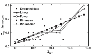
Water-Table Fluctuation (WTF) MethodMRC Approach of Heppner and Nimmo (2005)The Master Recession Curve (MRC) approach of Heppner and Nimmo (2005) was based on research conducted at a fractured rock site in Pennsylvania, USA. Development of the MRC using this approach begins by graphing the water-table elevation versus the decline rate for all time steps during which the water table was declining. The MRC curve can be constructed through this scatter plot using one of three methods: (1) a linear best fit to the data, (2) a power best fit to the data, or (3) by dividing the elevation range into “bins” and take the average decline rate for points in each bin. The linear and power best fits to the data yield a smooth MRC but require manual setting of minimum and maximum decline rates. Dividing the elevation range into bins results in a less smooth but entirely data-based MRC. More data produces a better MRC. The figure is an example showing the observed water-table elevation versus the water-table decline rate based on the bin-averaged method to produce the MRC.
After the MRC is developed it is applied to the water-level data set one data point at a time to predict the elevation at the following time step in the absence of recharge. This predicted water-table elevation is then compared to the observed elevation, with the difference between the two values is the DH(tj). If the predicted water level was greater than the observed water level, DH(tj). A detailed description of the MRC approach for estimating recharge is provided by Heppner and Nimmo (2005). |

![]() U.S. Department of the Interior |
U.S. Geological Survey
U.S. Department of the Interior |
U.S. Geological Survey
URL: http://water.usgs.gov/ogw/gwrp/methods/wtf/heppner_and_nimmo.html
Page Contact Information: Contact the Groundwater Resources Program
Page Last Modified: Tuesday, 03-Jan-2017 20:46:58 EST