USGS Groundwater Information
Groundwater Resources Program
![[Photo: Groundwater flowing out of well.]](/ogw/gwrp/images/flowingwell-vsm.jpg)
New & Noteworthy
USGS Groundwater WatchUSGS maintains a network of active wells to provide basic statistics about groundwater levels. ![[Image: USGS active water level wells location map.]](http://groundwaterwatch.usgs.gov/sm_ogw.png "USGS Groundwater Watch")
Other Water TopicsUSGS in Your StateUSGS Water Science Centers are located in each state. ![[Map: There is a USGS Water Science Center office in each State.]](/ogw/images/usmapsmall.gif)
|
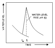
Water-Table Fluctuation (WTF) MethodEstimating the Water-Level Rise (DH(tj))
The water-level rise DH(tj) is estimated as the difference between the peak of a water-level rise and the value of the extrapolated antecedent recession curve at the time of the peak. The recession curve is the trace that the well hydrograph would have followed had there not been any recharge. Extrapolation of the recession curve is not always straightforward. At least two approaches can be used to estimate DH(tj) in the WTF method: graphical extrapolation and calculation from a master recession curve (MRC). A third approach used to estimate DH(tj), made on the basis of the computer code from the RISE program (A. Rutledge, U.S. Geological Survey, written commun., 2005), does not extrapolate for continuation of a hypothetical recession while the water table is rising. Because of the need for daily water-level data, the MRC and RISE approaches can be applied only at sites where water levels were continuously monitored. |

![]() U.S. Department of the Interior |
U.S. Geological Survey
U.S. Department of the Interior |
U.S. Geological Survey
URL: http://water.usgs.gov/ogw/gwrp/methods/wtf/estimating_rise.html
Page Contact Information: Contact the Groundwater Resources Program
Page Last Modified: Tuesday, 03-Jan-2017 20:46:53 EST