USGS Groundwater Information
Groundwater Resources Program
![[Photo: Groundwater flowing out of well.]](/ogw/gwrp/images/flowingwell-vsm.jpg)
New & Noteworthy
USGS Groundwater WatchUSGS maintains a network of active wells to provide basic statistics about groundwater levels. ![[Image: USGS active water level wells location map.]](http://groundwaterwatch.usgs.gov/sm_ogw.png "USGS Groundwater Watch")
Other Water TopicsUSGS in Your StateUSGS Water Science Centers are located in each state. ![[Map: There is a USGS Water Science Center office in each State.]](/ogw/images/usmapsmall.gif)
|
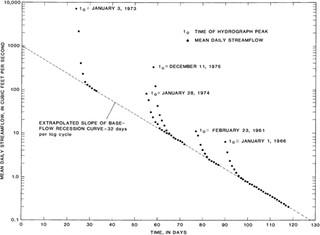
Recession-Curve Displacement Method for Estimating Groundwater Recharge In Humid RegionsManual Determination of KThe recession index can be determined by manual compilation of a master recession curve composed of numerous recession segments during periods when groundwater was the dominant component of flow for each streamflow-gaging station. An example of manual construction of a master recession curve is shown in the figure from Bevans (1986). The extrapolated base-flow recession on the semi-log plot defines a straight line that declines one log cycle in 32 days. Thus, recession index is 32 days for this watershed.
|

![]() U.S. Department of the Interior |
U.S. Geological Survey
U.S. Department of the Interior |
U.S. Geological Survey
URL: http://water.usgs.gov/ogw/gwrp/methods/recession_curve/manual_k.html
Page Contact Information: Contact the Groundwater Resources Program
Page Last Modified: Tuesday, 03-Jan-2017 20:46:34 EST