USGS Groundwater Information
Groundwater Resources Program
![[Photo: Groundwater flowing out of well.]](/ogw/gwrp/images/flowingwell-vsm.jpg)
New & Noteworthy
USGS Groundwater WatchUSGS maintains a network of active wells to provide basic statistics about groundwater levels. ![[Image: USGS active water level wells location map.]](http://groundwaterwatch.usgs.gov/sm_ogw.png "USGS Groundwater Watch")
Other Water TopicsUSGS in Your StateUSGS Water Science Centers are located in each state. ![[Map: There is a USGS Water Science Center office in each State.]](/ogw/images/usmapsmall.gif)
|
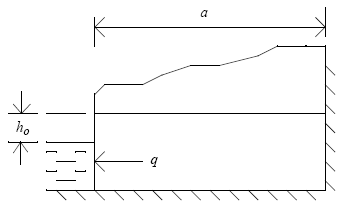
Recession-Curve Displacement Method for Estimating Groundwater Recharge In Humid RegionsKey Assumptions and Critical IssuesThe recession-curve displacement method assumes streamflow recessions represent groundwater discharge originating as spatially diffuse recharge and that the timing of recharge coincides generally with peaks in streamflow. Recharge is assumed to cause an instantaneous, uniform rise in groundwater levels throughout the basin as illustrated, where q = the groundwater discharge per unit of stream length (one side); ho = instantaneous water-table rise; and a = the distance from the stream to the hydrologic divide.
Snowmelt runoff, streamflow regulation, and release of water from wetlands or bank storage are sources of water other than groundwater discharge that could affect the shape of the recession curve and recharge estimates. It is incumbent on the user to evaluate how these sources could affect recharge estimates. Rutledge (2000 and 2004) provided guidance for evaluating the significance of many of the simplifying assumptions and sensitivity of the RORA model to key parameters. Because of the simplifying assumptions inherent in the equations, Halford and Mayer (2000) warned that RORA may not provide reasonable estimates of recharge. They concluded that "When used alone, the recession-curve-displacement method and other hydrograph-separation techniques are poor tools for estimating groundwater discharge or recharge because the major assumptions of the methods are commonly and grossly violated." Sun (2004) stated that recharge estimates from RORA are too large compared to water-budget estimates and base-flow separation. |

![]() U.S. Department of the Interior |
U.S. Geological Survey
U.S. Department of the Interior |
U.S. Geological Survey
URL: http://water.usgs.gov/ogw/gwrp/methods/recession_curve/key_assumptions.html
Page Contact Information: Contact the Groundwater Resources Program
Page Last Modified: Tuesday, 03-Jan-2017 20:46:33 EST