USGS Groundwater Information
Groundwater Resources Program
![[Photo: Groundwater flowing out of well.]](/ogw/gwrp/images/flowingwell-vsm.jpg)
New & Noteworthy
USGS Groundwater WatchUSGS maintains a network of active wells to provide basic statistics about groundwater levels. ![[Image: USGS active water level wells location map.]](http://groundwaterwatch.usgs.gov/sm_ogw.png "USGS Groundwater Watch")
Other Water TopicsUSGS in Your StateUSGS Water Science Centers are located in each state. ![[Map: There is a USGS Water Science Center office in each State.]](/ogw/images/usmapsmall.gif)
|
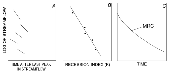
Recession-Curve Displacement Method for Estimating Groundwater Recharge In Humid RegionsAutomated Determination of KThe recession index (K) can also be determined by automated construction and analysis of the master recession curve for a watershed by the use of the RECESS program (Rutledge, 1998). RECESS is an interactive program requiring the hydrologist to pick nearly linear segments of the streamflow hydrograph for automated determination of the master recession curve and recession index. The procedure used by RECESS is shown schematically below, and is outlined in detail in Rutledge (1998).
New S-PLUS® Version of RECESS and SCREEN The RECESS program is being incorporated (2006) into S-PLUS® statistical/graphical package by the USGS Minnesota Water Science Center to allow easier analysis because of an enhanced ability to graphically analyze hydrograph data. S-PLUS provides a consistent user interface and the possibility of developing a graphical user interface. Functions are also being developed to plot the analyses; print a concise listing of the analysis; and extract summary information. These functions produce output that replaces the output files from the original programs and eliminate the need to use a separate program to plot the data. The enhancements include the programs to:
|

![]() U.S. Department of the Interior |
U.S. Geological Survey
U.S. Department of the Interior |
U.S. Geological Survey
URL: http://water.usgs.gov/ogw/gwrp/methods/recession_curve/auto_k.html
Page Contact Information: Contact the Groundwater Resources Program
Page Last Modified: Tuesday, 03-Jan-2017 20:46:26 EST