Data Set 2
|
PCKG ARR INTYP KLAY XL YL HYDLBL (free format)
(Input item 2 consists of one record for each hydrograph. No more than NHYD hydrograph records will be read.)
PCKG is a flag to indicate which package and which array in the X vector is to be addressed by HYDMOD for the hydrograph of each observation point. As new model packages are added, the Read-and-Prepare module can be appended with additional subroutines to access new packages or new arrays. These are the same names specified in the CUNIT array. The three current package options are the basic (BAS), streamflow routing (STR), and interbed storage (IBS) packages.
BAS for the Basic Package,
| • | IBS for the Interbed-Storage Package, |
| • | STR for the Streamflow Routing Package |
|
ARR is a text code indicating which model data value is to be accessed for the hydrograph of each observation point. The table of available values:
|
|
|
HD
|
Head (BAS package)
|
DD
|
Drawdown (BAS package)
|
HC
|
Preconsolidation-head (IBS1 package)
|
CP
|
Instantaneous compaction (IBS1 packages)
|
SB
|
Instantaneous subsidence array (IBS1 packages)
|
ST
|
Stream stage (STR package)
|
SI
|
Streamflow into reach (STR Package)
|
SO
|
Streamflow out of reach (STR Package)
|
SA
|
Streamflow into or out of aquifer array (STR Package)
|
|
INTYP is a 1-character value to indicate how the data from the specified feature are to be accessed. The two options are I for interpolated value or C for cell value. Interpolated value indicates that the value is linearly interpolated from values at the 4 nodes surrounding the hydrograph location. Cell value means the value at the node closest to the hydrograph location. INTYP must be C for STR and SFR hydrographs.
|
KLAY is the layer sequence number of the array to be addressed by HYDMOD. For arrays that exist for each model layer, such as head (HNEW), KLAY is the layer number. For arrays that exist for only certain model layers, KLAY is the sequence number of the array starting with the uppermost array as 1, the next lower array as 2, and so forth. For the subsidence option (ARR = ‘SB’), KLAY designates the range of layers (from layer 1 to layer "KLAY") used to sum compaction from individual layers into total subsidence for these layers.
|
XL is the coordinate of the hydrograph point in model units of length measured parallel to model rows, with the origin at the lower left corner of the model grid (fig. 2). The value of XL does not need to correspond with the location of any particular model node. For streamflow-related data, XL designates the segment number that contains the reach from the streamflow-input data set for which data are to be output.
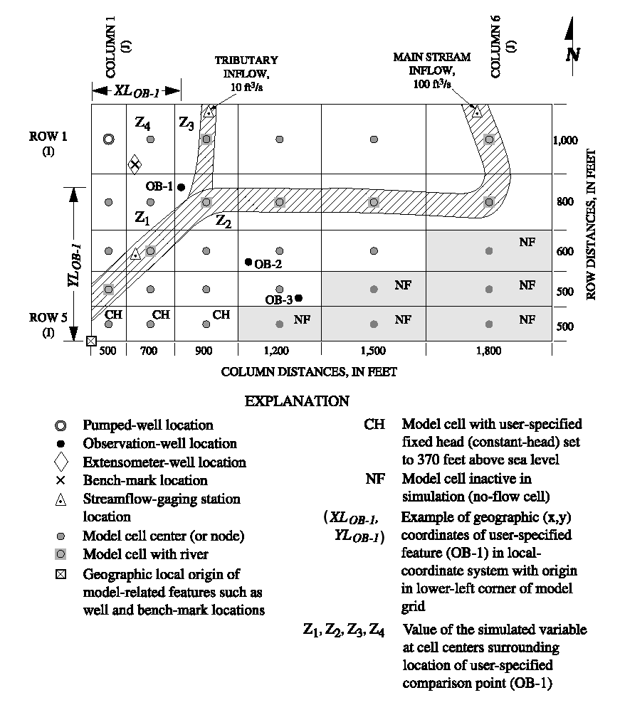
Figure 2. Diagram showing test problem layout and coordinates used for interpolation.
|
YL is the coordinate of the hydrograph point in model units of length measured parallel to model columns, with the origin at the lower left corner of the model grid (fig. 2). The value of YL does not need to correspond with the location of any particular model node. For streamflow-related data, YL designates the reach number that is the cell location from the streamflow-input data set for which data are to be output.
Figure 2. Diagram showing test problem layout and coordinates used for interpolation.
|
HYDLBL is used to form a label for the hydrograph. The purpose of the label is to identify output and allow users to reorder, add, or subtract from the input list and still maintain location identity. HYDLBL is up to 14 characters for the BAS, IBS, and SUB Packages. An additional 6 characters are added as a prefix to make a 20-character label. The first two characters of the prefix are the ARR characters. The third character is the INTYP value. Characters 4 through 6 are the KLAY value. For stream hydrographs, HYDLBL is up to 12 characters. The constructed prefix consists of the 2-character ARR value, the 3-digit stream-segment number (character locations 3 to 5), and the 3-digit stream-reach number (character locations 6 to 8). The prefix is added to HYDLBL to again make a 20-character hydrograph label.
|
|
|


