|
RMA: Study Area Description |
|
RMA: Study Area Description |
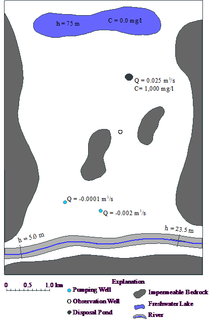
The map below (fig. 94) shows the area to be modeled. The aquifer is 12 m thick but it is not continuous. On the east and west are zones of impermeable bedrock where the aquifer is absent. There are two more zones of impermeable bedrock within the aquifer. In the north is a lake with a head of 75 m. In the south is a river with a head that varies from 23.5 m near its eastern end to 5 m near its western end. There is a small disposal pond south of the lake with a flux rate of 0.025 m3/s into the aquifer. Further south there are two pumping wells with pumping rates of 0.001 and 0.002 m3/s out of the aquifer.

Figure 94. Map of Rocky Mountain Arsenal study area.
The table below lists some of the properties of the aquifer. (Only some of these properties will be used in the model.)
Parameter values for two-dimensional sample problem |
|
Parameter |
Value |
hydraulic conductivity |
0.0001 m/s |
storage coefficient |
0 |
effective porosity |
0.2 |
saturated thickness |
12 m |
longitudinal dispersivity |
30 m |
horizontal transverse dispersivity |
3 m |
initial concentration |
0.0 mg/L |
total simulation time |
20 years |