National Water-Quality Assessment (NAWQA) Project
Go to:
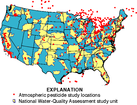
The geographic distribution of sampling in the United States for pesticides in the atmosphere has been highly uneven over the past three decades, with many areas of the nation never sampled, and other areas intensively sampled. The most extensive data collection efforts have been in the Great Lakes region and California (see Figure 2). For most studies, sites were located in or near agricultural areas and were generally short-term, seldom lasting more than one year. Study designs ranged from monitoring airborne concentrations of a single pesticide near its application site to nationwide studies that investigated concentrations of a wide variety of pesticides in air and precipitation.

Studies have varied widely in sampling methodologies, site placement, timing and duration, target analyses, analytical methods, and detection limits. Frequently, only compounds that were detected were reported and those compounds that were not detected were reported in very few studies. These inconsistencies greatly limit the use of existing data for national and regional assessment. For example, Figure 3 on the next page shows that the number and variety of pesticides detected in air (5 herbicides, 17 insecticides, 7 metabolites) are greater than those detected in rain (6 herbicides, 5 insecticides, 4 metabolites). This does not mean that rain contains less pesticides than air; rather, it results from rain not being analyzed for pesticides as often and at as many sites as air. However, with careful qualification, some important conclusions emerge.