U.S. Geological Survey
National Water-Quality Assessment Program
USGS Internal Access Only
Regional Framework
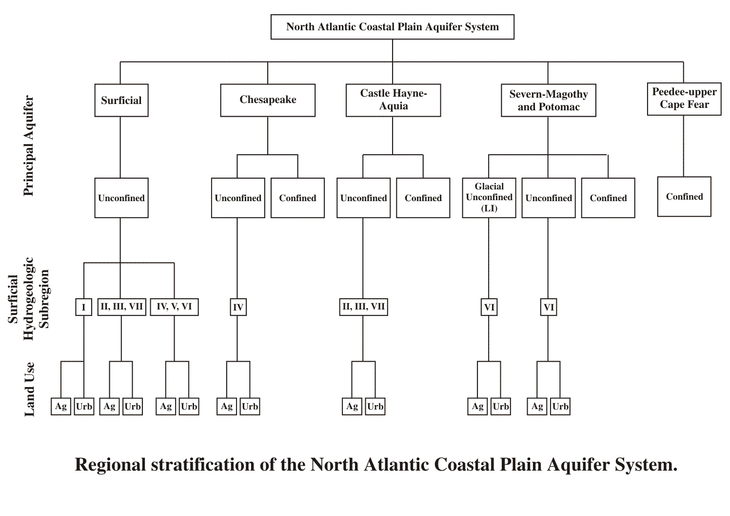
Regional stratification consists of consideration of 3 primary factors:
(1) the geographic extent of each primary aquifer,
(2) anthropogenic susceptibility which is the set of natural factors that govern the likelihood that anthropogenic contaminants will leach to the ground-water system, and
(3) vulnerability which refers to the degree to which sources of contamination are present in the recharge area of a susceptible system. Susceptible systems in which no sources of contamination exist would be assigned low vulnerability, whereas, susceptible systems that have sources of contamination in their recharge areas would be considered vulnerable to contamination.
The first step in regional stratification is to determine the geographic extent of where each primary aquifer is hydraulically connected to land surface (unconfined vs. confined). In those areas where an aquifer is confined, the system is considered less susceptible to contaminants introduced by anthropogenic activities than in those areas where the aquifer is unconfined.
The second step in regional stratification involves determining the relative degree of susceptibility for systems that are more susceptible (unconfined) to anthropogenic contamination as defined by overlaying the surficial hydrogeologic subregions. Surficial hydrogeologic subregions define areas in which the natural physical factors that govern the transport of contaminants to shallow ground water are relatively consistent (table 1). The 7 hydrogeologic subregions represent areas of similar geology and form a continuum of natural physical factors (Ator and others, 2000). In a general sense, Subregions I and IV represent end members of this continuum. Subregion I consists of flat lying, poorly drained soils that are low in DO and rich in organic matter content. These conditions generally result in low nitrate concentrations and are not conducive to the transport of pesticides and other organic compounds. Subregion IV consists of well-drained sands and gravels that are well oxygenated and low in organic matter content. These conditions favor the formation of nitrate and the movement of nitrate and pesticides and other organic compounds from land surface to shallow ground water. For the purpose of this stratification, subregions V and VI are grouped with subregion IV because of the sandy, well-weathered nature of the surficial sediments. Subregions II, III, and VII exhibit mixed surficial sediment characteristics and are also grouped together.
The third step in regional stratification is to determine aquifer vulnerability . Land use is a surrogate variable representing the type and amount of contaminant applied at land surface. Numerous investigations in the NACPAS have documented that contaminant occurrence and distribution is significantly related to land-use setting (Ayers and others, 2000; Shedlock and others, 1999; Spruill and others, 1998).
The NACPAS was stratified based on the hydrogeologic framework, surficial hydrogeologic subregions, and distribution of land use. For the purpose of stratification, the Cretaceous Severn – Magothy and