
U.S. Geological Survey
National Water-Quality Assessment Program
USGS Internal Access Only
ENVIRONMENTAL FRAMEWORK
Three main factors comprise the environmental framework for studying water quality in the area covered by the Basin and Range regional aquifer system: hydrogeologic setting, water use, and land use. The primary hydrogeologic setting and the one most common among the GRSL, NVBR, and CAZB study units in the Basin and Range regional aquifer system is the setting of unconsolidated basin-fill aquifers. This setting has been and will continue to be the focus of study for these NAWQA study units.
The Basin and Range regional aquifer system occurs within the Basin and Range physiographic
The basin-fill aquifers are the principal source of ground water for domestic and municipal supply and for irrigated agriculture in the Basin and Range region. These uses of water account for most of the water use in this region. Most basins are topographically and hydraulically closed by low permeability bedrock or are only partially drained by perennial streams or by flow through basin-fill deposits or permeable bedrock. Contaminants reaching these aquifers are more likely to be retained and concentrated.
The source of recharge water to the basin-fill aquifers is an important attribute of the hydrogeologic framework that needs to be considered in the study design. Basin-fill deposits usually range in thickness from zero at margins of valleys to several thousand feet in valley lowlands. Recharge primarily occurs along the mountain front in the NVBR and GRSL study units whereas the primary source of recharge in the CAZB study unit is streambed recharge within the basins.
Carbonate rocks form a regional aquifer system in the eastern part of the Great Basin that includes the eastern part of
The carbonate-rock aquifers are not currently utilized for public supply because of their remoteness and depth to water. As population growth continues in arid areas with limited water supplies, these aquifers are likely to be drawn upon to meet future water needs in the region. Characterization of the water quantity and quality of the carbonate-rock aquifers would be advisable. NAWQA should make every effort to make available the resources to undertake this characterization. To encourage this effort, a proposal to do a Major Aquifer Study of the carbonate-rock aquifers in the Basin and Range has been forwarded to the NAWQA National Leadership Team. The
The other hydrogeologic settings in the Basin and Range regional aquifer system (basalt and volcanic-rock aquifers and sandstone aquifers) are not aerially extensive, do not supply much of the water used, with the exception of the Fallon area in
Besides hydrogeology, land use and the corresponding water use are the other main factors in determining the environmental framework for the Basin and Range region.
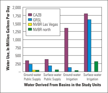 Urban and agricultural land uses are the most important because of their effects on water quality. The parts of the Basin and Range region covered by NAWQA study units are rapidly urbanizing (greater than 21% increase in population in
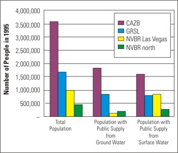 Most of the ground and surface water used in the Basin and Range region is applied as irrigation to crops or is used for public supply. Crops in the region generally must be irrigated with either surface or ground water or a combination of both. Ground water, surface water imported from the

