
DATA SOURCES AND DATA QUALITY
The RESSED database represents, to the best of the knowledge of the Subcommittee on Sedimentation, the largest single programmatically based reservoir sedimentation-survey database available for the United States (U.S.). It has evolved from the pre-computer paper era to its current incarnation, a Microsoft® Access® database containing all information keyed in from user-completed Soil Conservation Service (SCS) Form 34 datasheets. It is an augmentation of the recently published and static RESIS-II database (Ackerman et al., 2009) and includes additional records.
Some RESSED characteristics of potential interest to database users follow:
Of the 6,617 surveys in 1,823 reservoirs (figure 1) identified by Ackerman et al. (2009) over the period 1755-1993 (figure 2), 95-percent of the surveys took place between 1930-1990.
Limited information was recorded on the data sheets for land use and cover conditions that existed in a reservoirs watershed for the time represented by recorded sediment surveys. Some additional information was included in the form as footnotes. The data recorded were, in many cases, the only record associated with sedimentation surveys. Some other surveys resulted in stand-alone, detailed published reports.
Reservoir-location information requested on SCS Form 34 included latitude and longitude in degrees, minutes, and seconds; and section, township, and range. Many of the original latitude and longitude coordinates are imprecise, which is an inherent problem with most historical georeferenced databases. The efforts to improve georeferencing described in the background section improved the precision of the majority of the reservoir location data in RESIS-II (ergo, in RESSED). However, some of the reservoir-location data remain questionable, and users are advised to be aware of obvious and potential inaccuracies in RESSED location coordinates as well. Users are also encouraged to provide demonstrably reliable georeferenced data for RESSED.
To improve locations for RESSED reservoirs and provide users with an indication of the quality of reservoir locations, a Location Determination Method code is included in RESSED. This method assigned an integer value to each reservoir to indicate the method used to generate the latitude/longitude. This value is in the LL_METHOD field in the Lat_Lon_New table of RESSED.
Each reservoir plotted on the interactive map is colored using the LL_METHOD code listed in table 1 below.
Table 1. Location Determination Method Color Codes providing qualitative insights into the accuracy of RESSED locations on the RESSED Interactive Map.
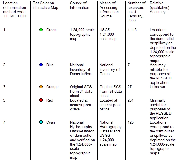
In the above table, for method 2 (blue), the source of information and the method of accessing the information should be National Inventory of Dams.
