USGS Surface Water Information
Selected USGS Surface-Water Publications
New & Noteworthy
USGS in Your StateUSGS Water Science Centers are located in each state. ![[Map: There is a USGS Water Science Center office in each State.]](http://www.usgs.gov/frameworkfiles/includes/imagemaps/usmapsmall.gif)
Other Water SitesPDF Reader!Documents are presented in Portable Document Format (PDF); the latest version of Adobe Reader or similar software is required to view it. Download the latest version of Adobe Reader, free of charge. |
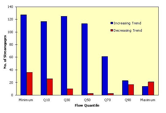
Reprinted from Geophysical Research Letters, v. 26, p. 227-230. Not subject to U.S. copyright< Download this report as a PDF file (3.1M) Download a free copy of Acrobat Reader Streamflow trends in the United StatesHarry F. Lins and James R. SlackU.S. Geological Survey, 415 National Center, Reston, VA 20192, USAAbstract. Secular trends in streamflow are evaluated for 395 climate-sensitive streamgaging stations in the conterminous United States using the non-parametric Mann-Kendall test. Trends are calculated for selected quantiles of discharge, from the 0th to the 100th percentile, to evaluate differences between low-, medium-, and high-flow regimes during the twentieth century. Two general patterns emerge; trends are most prevalent in the annual minimum (Q0) to median (Q50) flow categories and least prevalent in the annual maximum (Q100) category; and, at all but the highest quantiles, streamflow has increased across broad sections of the United States. Decreases appear only in parts of the Pacific Northwest and the Southeast. Systematic patterns are less apparent in the Q100 flow. Hydrologically, these results indicate that the conterminous U.S. is getting wetter, but less extreme. 1. IntroductionFloods and droughts cause more damage annually in the United States than any other natural disaster. There is an increasing trend in both flood damage and drought vulnerability (Federal Interagency Floodplain Management Task Force, 1992; U.S. Army Corps of Engineers, 1995; Wilhite, 1997). Most of the flood damage increase stems from continuing urban and suburban development on floodplains and the drought vulnerability increase is from development in regions of lower renewable water supplies. However, there is also a perception that extreme hydrologic events are increasing in frequency and/or magnitude. Most documentation of trends in surface water hydrologic conditions has focused on monthly and annual mean discharge or the timing of monthly mean discharge (Chiew and McMahon, 1996; Lettenmaier et al., 1994; Lins and Michaels, 1994). Since the 1940's, the general pattern has been toward an increase in mean discharge in the autumn and winter months in most regions of the conterminous United States. Systematic analysis of trends across the spectrum of streamflows, including flood- and low-flows, has received little treatment. Significantly, however, the Mississippi floods of 1993 and the widespread flooding during 1997 in the West, Upper Midwest, and the Ohio Valley, as well as the widespread 1988 and 1995-96 drought, gave rise to speculation that floods and droughts are increasing; possibly in response to greenhouse warming. We consider the question of any changes in hydrologic regime by determining whether trends have occurred in streamflow over a range of discharge quantiles.2. Data and MethodsA compilation of daily discharge records, relatively free of such anthropogenic influences as watercourse regulation, diversion, ground-water pumpage, or land use change, was developed by the U. S. Geological Survey (USGS) to study climatically-induced variations in U. S. surface-water conditions (Slack and Landwehr, 1992). Known as the Hydro-Climatic Data Network (HCDN), it includes data from more than 1500 streamgages. We use a subset of the HCDN consisting of daily mean discharge from 395 stations that provide broad spatial coverage of the hydrology of the United States. The 395 stations represented the maximum number furnishing continuous daily records over the 50-year period 1944-1993, with a decreasing number of stations providing data at longer time periods; 193 at 60 years (1934-93), 70 at 70 years (1924-93), and 34 at 80 years (1914-93). Although more than 395 stations had continuous data for periods less than 50 years, we wanted to maximize sample size and maintain site continuity over 30-, 40-, and 50-year periods, while not compromising spatial coverage. Trends in the HCDN records are evaluated using the nonparametric Mann-Kendall test. The test examines whether a random response variable monotonically increases or decreases with time. It is a rank-based procedure, resistant to the influence of extremes, and good for use with skewed variables. No assumption of normality is required, although there must be no serial correlation for the resulting p-values to be correct (Helsel and Hirsch, 1992). These characteristics make it particularly appropriate for use with streamflow data sampled up to one year apart. Our approach to the assessment of trends in streamflow involves two distinct elements. First, we test for trends in 7 quantiles of the streamflow distribution, by selected decimals, from the annual minimum (daily mean) (Q0) to the annual maximum (daily mean) (Q100). This includes the 90th (Q90), 70th (Q70), 50th (Q50), 30th (Q30), and 10th (Q10) percentiles. In so doing, we derive a more complete picture of how the streamflow regime is changing over the entire discharge spectrum. Second, we evaluate interdecadal streamflow variability by calculating the quantile trends for 30-, 40-, 50-, 60-, 70-, and 80-year periods, all ending in 1993. This provides some insights as to how the characteristics of hydrologic trends during the century are affected by the period-of-record.3. ResultsTrend test results, by quantile and period-of-record, are summarized in Table 1. Moving from low- to high-flows, we first consider the annual minimum (daily mean) discharge (Q0), which we use as a surrogate measure of hydrologic drought. The Q0 flow represents the lowest recorded mean daily discharge at a gage each year and generally reflects baseflow conditions. It exhibits a strong pattern of trends through the twentieth century. The percentage of the streamgaging stations recording statistically significant trends ranges from a low of 28 percent at 30 years of record to a high of 49 percent at 70 years of record. Significantly, there are many more uptrends than downtrends nationally; that is, the broad pattern is toward increasing annual minimum streamflow. The uptrends exceed the downtrends by 4 to 1 when averaged over all time periods. Progressing through the lower to middle range of streamflows (Q10 - Q50), the pattern that emerges is quite similar to that for the annual minimum discharge; that is, numerous statistically significant trends (25-46 percent of the stations), with many more increases than decreases. However, the situation changes noticeably in the upper half of the discharge distribution. At the Q70 flow, the number of stations with significant trends drops to 23 percent, averaged over the six time periods. At Q90 the average percentage drops to 14 and finally, at the annual maximum flow, only 11 percent of the stations have significant trends. Of perhaps more note is the change in the mix of up- and downtrends. In the low to middle flows there is a clear predominance of uptrends. At the high flows, uptrends and downtrends are roughly equal. This variation in trends across quantiles is illustrated in Figure 1. The graph covers the period 1944-1993, but the same general pattern is evident in each of the six time periods. There are two important characteristics in the figure. First, the number of increasing streamflow trends is high and approximately equal across the lower half of the flow distribution, but falls sharply across the upper half. Second, downtrends decrease in number from the Q0 to Q50 flow, but increase from the Q50 to Q100 flow. This pattern indicates that baseflows are increasing (which suggests that drought is decreasing), median or average streamflow is increasing, but annual maximum flows (including floods) are neither increasing nor decreasing. Hydrologically, the nation appears to be getting wetter, but less extreme.
4. DiscussionAlthough the specific causes of these variations are not simply and immediately explained, their broad spatial consistency is sufficient to suggest some systematic cause or causes. For example, the increases observed in the northeastern quarter of the nation could be associated with precipitation patterns linked with the recent and persistent high index phase of the North Atlantic Oscillation (Hurrell, 1995; Hurrell and van Loon, 1997). The decreases in the Pacific Northwest, especially given the opposing increases in the Southwest, may reflect decadal-scale variations in the tropical and North Pacific Ocean (Dettinger and Cayan, 1995; Graham, 1994; Latif and Barnett, 1994). Opposing climatic and hydrologic anomalies between the Pacific Northwest and the Southwest are well documented as occurring in conjunction with various North Pacific atmospheric circulation modes (Lins, 1997; Cayan and Peterson, 1989). Climate model simulations associated with increasing atmospheric CO2 have been interpreted (e.g. Houghton et al., 1996) as indicating an intensification of the hydrologic cycle. This is generally translated to mean more extreme hydrologic events such as floods and droughts. One recent analysis of observed data appears to lend some support to these simulations by indicating that, "at least within the United States--the proportion of total precipitation contributed by extreme, one-day events has increased significantly" during the twentieth century (Karl et al., 1995). We suspect that our streamflow findings are consistent with the precipitation findings of Karl and his collaborators (1995, 1998). The reported increases in precipitation are modest, although concentrated in the higher quantiles. Moreover, the trends described for the extreme precipitation category (>50.4mm per day) are not necessarily sufficent to generate an increase in flooding. It would be useful to know if there are trends in 24-hour precipitation in the >100mm and larger categories. The term "extreme," in the context of these thresholds, may have more meaning with respect to changes in flood hydrology. What, if anything, do our results imply for the hypothesis that increasing atmospheric CO2 will lead to an enhanced hydrologic cycle and, therefore, more floods and droughts? This is a more problematic issue, and one on which current climate modeling studies may soon be able to shed some light. Acknowledgements. We thank K. Wahl, K. Potter, and S. Burges for thoughtful reviews. Special thanks also to S. Hostetler for many critical comments and numerous insightful discussions.ReferencesCayan, D. R., and D. H. Peterson, The influence of North Pacific atmospheric circulation on streamflow in the west, in Aspects of Climate Variability in the Pacific and the Western Americas, Geophys. Monogr. Ser., vol.55, edited by D. H. Peterson, pp. 365-374, AGU, Washington, D. C., 1989. Chiew, F.H.S., and T.A. McMahon, Trends in historical streamflow records, in Regional Hydrological Response to Climate Change, edited by J.A.A. Jones et al., pp. 63-68, Kluwer Academic Publishers, Amsterdam, 1996. Dettinger, M. D., and D. R. Cayan, Large-scale atmospheric forcing of recent trends toward early snowmelt runoff in California, J. Clim., 8, 606-623, 1995. Federal Interagency Floodplain Management Task Force, Floodplain Management in the United States: An Assessment Report, FIA-18, Federal Insurance Agency, Washington, D. C., 1992. Graham, N. E., Decadal-scale climate variability in the tropical and North Pacific during the 1970s and 1980s: observations and model results, Climate Dynamics, 10, 135-162, 1994. Helsel, D. R., and R. M. Hirsch, Statistical Methods in Water Resources, Elsevier Science Publishers, Amsterdam, 1992. Houghton, J. T., L. G. Meira Filho, B. A. Callander, N. Harris, A. Kattenberg, and K. Maskell (Eds.), Climate Change 1995: The Science of Climate Change, Cambridge University Press, Cambridge, 1996. Hurrell, J. W., Decadal trends in the North Atlantic oscillation: regional temperatures and precipitation, Science, 269, 676-679, 1995. Hurrell, J. W., and H. van Loon, Decadal variations in climate associated with the North Atlantic oscillation, Climatic Change, 36, 301-326, 1997. Karl, T. R., and R. W. Knight, Secular trends of precipitation amount, frequency, and intensity in the USA, Bull. Am. Meteorol. Soc., 79, 231-241,1998. Karl, T. R., R. W. Knight, and N. Plummer, Trends in high-frequency climate variability in the twentieth century, Nature, 377, 217-220, 1995. Latif, M., and T. P. Barnett, Causes of decadal climate variability over the North Pacific and North America, Science, 266, 634-637, 1994. Lettenmaier, D. P., E. F. Wood, and J. R. Wallis, Hydro-climatological trends in the continental United States, 1948-88, J. Clim., 7, 586-607, 1994. Lins, H. F., Regional streamflow regimes and hydroclimatology of the United States, Water Resour. Res., 33, 1655-1667, 1997. Lins, H. F. and P. J. Michaels, Increasing U.S. streamflow linked to greenhouse forcing, Eos Trans. AGU, 75, 281, 284-285, 1994. Slack, J. R., and J. M. Landwehr, Hydro-climatic data network: a U. S. Geological Survey streamflow data set for the United States for the study of climate variations, 1874-1988, U. S. Geol. Surv. Open-File Rept. 92-129, 1992. U. S. Army Corps of Engineers, Annual Flood Damage Report to Congress for Fiscal Year 1995, Washington, D. C., 1996. Wilhite, D. A., State actions to mitigate drought: lessons learned, J. Am. Water Resour. Assoc., 33, 961-968, 1997. Received: November 6, 1998Revised: December 2, 1998 Accepted: December 3, 1998 | |||||||||||||||||||||||||||||||||||||||||||||||||||||||||||||||||||||||||||||||||||||||||||||||||||||||||||||||||||||||||||||||||

![]() U.S. Department of the Interior |
U.S. Geological Survey
U.S. Department of the Interior |
U.S. Geological Survey
URL: http://water.usgs.gov/osw/pubs/lins/streamflowtrends.html
Page Contact Information: USGS Office of Surface Water
Page Last Modified: Wednesday, 21-Jan-2009 19:13:26 EST

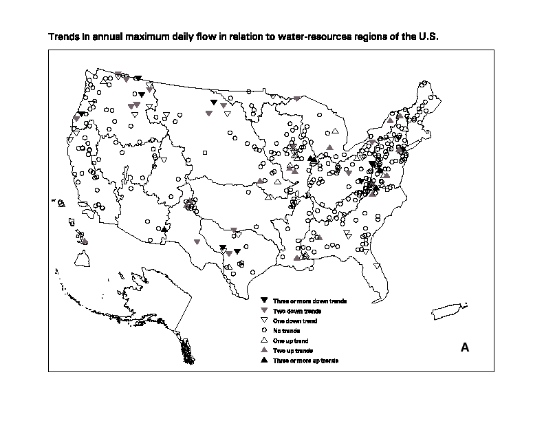
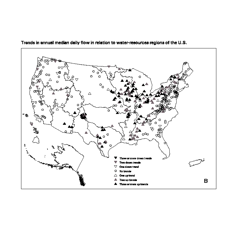
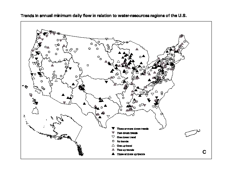
 ) denote stations
exhibiting a trend in 3 or more time periods shown in Table 1;
gray-shaded triangles (
) denote stations
exhibiting a trend in 3 or more time periods shown in Table 1;
gray-shaded triangles ( ) denote
2 time periods; open triangles (
) denote
2 time periods; open triangles ( ) denote a trend
in 1 time period; and an open circle (
) denote a trend
in 1 time period; and an open circle ( ) denotes no trend in any time period.