GROUND WATER RESOURCES FOR THE FUTURE
Land Subsidence in the United States
USGS Fact Sheet-165-00
December 2000
This report is also available in PDF format. (This report was previously printed and posted on this Web site as "FS-087-00." The correct report number is "FS-165-00".)
Download Fact Sheet as (3.98MB PDF)
Adobe Acrobat Reader™ is required to view the report and can be downloaded for free.
Ground water is among the Nation's most important natural resources. It provides
drinking water to urban and rural communities, supports irrigation
and industry, sustains the flow of streams and rivers, and maintains
riparian and wetland ecosystems. In many areas of the Nation, the
future sustainability of ground-water resources is at risk from overuse
and contamination. Because ground-water systems typically respond
slowly to human actions, a long-term perspective is needed to manage
this valuable resource. This publication is one in a series of fact
sheets that describe ground-water-resource issues across the United
States, as well as some of the activities of the U.S. Geological Survey
that provide information to help others develop, manage, and protect
ground-water resources in a sustainable manner.
![[Photo: Figure 1 - Sinkhole in west-central Florida.]](Images/fig1.jpg)
Figure 1. Development of a new irrigation well in west-central Florida triggered hundreds of sinkholes over a 20-acre area. The sinkholes ranged in size from less than 1 foot to more than 150 feet in diameter.
A recent U. S. Geological Survey (USGS) report (Galloway and others, 1999) shows that sustainable
development of our land and water resources depends on improved
scientific understanding and detection of subsidence. The
report features nine illustrative case studies that demonstrate
the role of subsurface water in human-induced land subsidence
(http://pubs.usgs.gov/circ/circ1182). More than 80 percent
of the identified subsidence in the United States is a consequence
of human impact on subsurface water, and is an often overlooked
environmental consequence of our land and water-use practices.
The increasing development of our land and water resources
threatens to exacerbate existing land-subsidence problems
and initiate new one (fig.1).
Land subsidence is a gradual settling or sudden sinking of the Earth's surface owing to subsurface movement of earth
materials. Subsidence is a global problem and, in the United
States, more than 17,000 square miles in 45 States, an area
roughly the size of New Hampshire and Vermont combined, have
been directly affected by subsidence. The principal causes
are aquifer-system compaction, drainage of organic soils,
underground mining, hydrocompaction, natural compaction, sinkholes,
and thawing permafrost (National Research Council, 1991).
Three distinct processes account for most of the water-related
subsidence--compaction of aquifer systems, drainage and subsequent
oxidation of organic soils, and dissolution and collapse of
susceptible rocks.
Mining Ground Water
![[Photo: Figure 2 - Pole with signs on the pole mark altitude of land surface in 1925, 1955, and 1977.]](Images/fig2.jpg)
Figure 2. Approximate location of maximum subsidence in the United States identified by research efforts of Dr. Joseph F. Poland (pictured). Signs on pole show approximate altitude of land surface in 1925, 1955, and 1977. The site is in the San Joaquin Valley southwest of Mendota, California.
The compaction of unconsolidated aquifer
systems that can accompany excessive ground-water pumping
is by far the single largest cause of subsidence. The overdraft
of such aquifer systems has resulted in permanent subsidence
and related ground failures. In aquifer systems that include
semiconsolidated silt and clay layers (aquitards) of sufficient
aggregate thickness, long-term ground-water-level declines
can result in a vast one-time release of “water of compaction”
from compacting aquitards, which manifests itself as land
subsidence (fig. 2). Accompanying this release of water is
a largely nonrecoverable reduction in the pore volume of the
compacted aquitards, and thus a reduction in the total storage
capacity of the aquifer system. This “water of compaction”
cannot be reinstated by allowing water levels to recover to
their predevelopment status. The extraction of this resource
for economic gain constitutes “ground-water mining”
in the truest sense of the term.
![[Map: Figure 3 - Map of U.S. areas where subsidence has been attributed to compaction of aquifer systems by ground-water pumpage.]](Images/fig3.jpg)
Figure 3. Some of the areas where subsidence has been attributed to the compaction of aquifer systems caused by ground-water pumpage.
![[Photo: Figure 5 - Earth fissures in south-central Arizona]](Images/fig5.jpg)
Figure 5. Some of the most spectacular examples of subsidence-related earth fissures occur in south-central Arizona.
![[Photo: Figure 4 - Flooded homes.]](Images/fig4.jpg)
Figure 4. Homes at Greens Bayou near Houston, Texas, where 5 to 7 feet of subsidence has occurred, were flooded during a storm in June 1989.
Five case studies demonstrate how agricultural and municipal-industrial ground-water use have
depleted critical ground-water resources and created costly
regional-scale subsidence (fig. 3). These include the Santa
Clara Valley in northern California, where early agricultural
ground-water use contributed to subsidence that has permanently
increased flood risks in the greater San Jose area. In nearby
San Joaquin Valley, one of the single largest
human alterations of the Earth's surface topography has resulted
from excessive ground-water pumpage to sustain an exceptionally
productive agriculture (fig. 2). The banner photo (top of page)
shows the California Aqueduct coarsing through the San Joaquin
Valley. The aqueduct conveys water from the Sacramento-San Joaquin
Delta to basins affected by subsidence in central and southern
California. Early oil and gas production and a long history
of ground-water pumpage in the Houston-Galveston
area, Texas, have created severe and costly coastal-flooding
hazards and affected a critical environmental
resource—the Galveston Bay estuary (fig. 4). In Las
Vegas Valley, Nevada, ground-water depletion and associated
subsidence have accompanied the conversion of a desert oasis
into a thirsty and fast-growing metropolis. Water-intensive
agricultural practices in south-central Arizona
caused wide-spread subsidence and fissuring of the Earth's surface
(fig. 5). In each of these areas, however, importation of surface
water has reduced or stabilized ground-water pumpage, thereby
halting or slowing subsidence, at least temporarily.
Drainage of Organic Soils
![[Map: Figure 6 - Distribution of organic soils of the U.S.]](Images/fig6.jpg)
Figure 6. Most organic soils occur in the northern contiguous 48 States and Alaska
Land subsidence invariably occurs when soils rich in organic
carbon are drained for agriculture or other purposes. The most
important cause of this subsidence is microbial decomposition,
which, under drained conditions, readily converts organic carbon
to carbon-dioxide gas and water. Compaction, desiccation, erosion
by wind and water, and prescribed or accidental burning can
also be significant factors.
The total area of organic soils in the United States is roughly
equivalent to the size of Minnesota, about 80,000 square miles,
nearly half of which is "moss peat" located in Alaska (Lucas,
1982) (fig. 6). About 70 percent of the organic-soil area in
the contiguous 48 states occurs in northerly, formerly
glaciated areas, where moss peats are also common (Stephens
and others, 1984). Moss peat is composed mainly of sphagnum
moss and associated species. It is generally very acidic (pH
3.5 to 4) and, therefore, not readily decomposed, even when
drained. However, where moss peat is amended for agricultural
cultivation, for example through fertilization and heavy application
of lime to raise the pH, it can decompose nearly as rapidly
as other types of organic soils.
![[Photo: Figure 7 - Everglades Station with stairs added to front porch.]](Images/fig7.jpg)
Figure 7. This building at the Everglades Experiment Station was originally constructed at the land surface; latticework and stairs were added after substantial land subsidence.
Two case studies of organic-soil subsidence focus on examples of rapid subsidence (1 to 3 inches/year)
caused by decomposition of the remains of shallow-water sedges
and reeds. In two of the Nation's important wetland ecosystems — the
Sacramento-San Joaquin Delta of California
and the Florida Everglades — continuing
organic-soil subsidence threatens agricultural production, affects
engineering infrastructure that transfers water supplies to
large urban populations, and complicates ongoing ecosystem-restoration
efforts sponsored by the Federal and State governments. Subsidence-weakened
levees increase the potential for flooding of Delta islands,
which could in turn disrupt freshwater flows and threaten the
integrity of the vast north-to-south water-transfer system in
California. In the Everglades agricultural area, where the value
of all agricultural crops is currently about $750 million (Snyder
and Davidson, 1994), agriculture as currently practiced has
a finite life expectancy because of the ongoing subsidence (fig.
7).
Collapsing Cavities
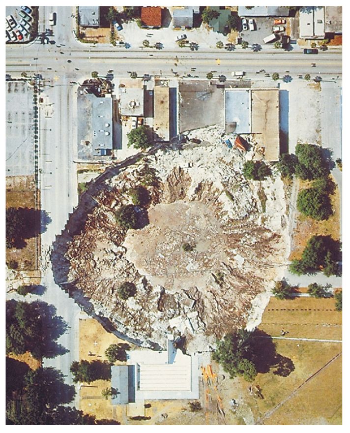
Figure 8. Collapse sinkholes, such as this one in Winter Park, Florida (1981), may develop abruptly (over a period of hours) and cause catastrophic damage.
The sudden and sometimes catastrophic subsidence associated
with localized collapse of subsurface cavities (sinkholes) (fig.
8) is detailed in two case studies. This type of subsidence
is commonly triggered by ground-water-level declines caused
by pumping and by enhanced percolation of ground water. Collapse
features tend to be associated with specific rock types, such
as evaporites (salt, gypsum, and anhydrite) and carbonates (limestone
and dolomite) (fig. 9). These rocks are susceptible to dissolution
in water and the formation of cavities Salt and gypsum are much
more soluble than limestone, the rock type most often associated
with catastrophic sinkhole formation.
Evaporite rocks underlie about 35 to 40 percent of the United
States, though in many areas they are buried at great depths
(Martinez and others, 1998). Natural solution-related subsidence
has occured in each of the major salt basins in the United States
(Ege, 1984). The high solubilities of salt and gypsum permit
cavities to form in days to years, whereas cavity formation
in carbonate bedrock is a very slow process that generally occurs
over centuries to millennia. Human activities can expedite cavity
formation in these susceptible materials and trigger their collapse,
as well as the collapse of pre-existing subsurface cavities.
Though the collapse features tend to be highly localized, their
impacts can extend beyond the collapse zone via the potential
introduction of contaminants to the ground-water system. Two
cavity-collapse case studies — Retsof, New York,
and west-central Florida — document human-induced
cavity collapses in salt and limestone, respectively.
The Role of Science
The occurrence of land subsidence is seldom as obvious as it
is in the case of catastrophic sinkholes or mine collapses.
Where ground-water mining or drainage of organic soils are involved,
the subsidence is typically gradual and widespread, and its
discovery becomes an exercise in detection. Gazing out over
the San Joaquin Valley, California today, one would be hard-pressed
to recognize that fewer than 75 years ago the land surface was
nearly 30 feet higher in some locations (fig. 2). Subsidence
detection and mapping programs are critical to the scientific
understanding and management of our land and water resources.
The detection of regional-scale subsidence has historically
depended on the discovery that key bench marks have moved. Land
surveys establish bench-mark positions to accurately locate
roadways, flood and drainage-control structures, pipelines,
and other engineered infrastructure. Once unstable bench marks
are discovered, and truly stable bench marks have been established,
subsidence can be mapped. This has traditionally been accomplished
using spirit leveling and, more recently, Global Positioning
System (GPS) surveys. A new tool has emerged in the past decade
that has dramatically improved our capability to detect and
map land-surface deformation.
This tool, interferometric synthetic aperture
radar (InSAR), uses repeat-pass radar images from Earth-orbiting
satellites to measure subsidence and uplift at unprecedented
levels of spatial detail (80 m x 80 m) and measurement resolution
(sub-centimeter) (Galloway and others, 2000) (fig. 10).
Once subsidence is identified and mapped, subsidence-monitoring
programs can be implemented and scientific studies can be launched
to improve our understanding of the subsidence processes. A
combination of scientific understanding and careful management
can minimize the subsidence that results from developing our
land and water resources.
— D.L. Galloway, D.R. Jones, S.E. Ingebritsen
References
Amelung, F., Galloway, D.L., Bell,
J.W., Zebker, H.A., and Laczniak, R.J., 1999, Sensing the
ups and downs of Las Vegas—InSAR reveals structural control of
land subsidence and aquifer-system deformation: Geology, v. 27, p.
483-486.
Clawges, R. M., and Price, C. V., 1999, Digital data
sets describing principal aquifers, surficial geology, and ground-water
regions of the conterminous United States: U.S. Geological Survey
Open-File Report 99-77 [accessed Sept. 17, 1999 at URL http://pubs.usgs.gov/ofr/ofr99-77].
Davies, W.E., and Legrand, H.E., 1972, Karst of the
United States, in Herak, M., and Stringfield, V.T., eds., Karst—Important
karst regions of the northern hemisphere, p. 467-505.
Ege, J.R., 1984, Mechanisms of surface subsidence
resulting from solution extraction of salt, in Holzer, T.L., ed.,
Man-induced land subsidence: Geological Society of America Reviews
in Engineering Geology, v. 6, p. 203-221.
Galloway, D.L., Jones, D.R., and Ingebritsen, S.E.,
1999, Land subsidence in the United States: U.S. Geological Survey
Circular 1182, 175 p.
Lucas, R.E., 1982, Organic soils (Histosols)—Formation,
distribution, physical and chemical properties and management for
crop production: Michigan State University Farm Science Research Report
435, 77 p.
Martinez, J.D., Johnson, K.S.,
and Neal, J.T., 1998, Sinkholes in evaporite rocks: American
Scientist, v. 86, p. 38-51.
National Research Council, 1991, Mitigating losses
from land subsidence in the United States: Washington, D. C., National
Academy Press, 58 p.
Snyder, G.H., and Davidson, J.M., 1994, Everglades
agriculture: Past, present, and future, in Davis, S.M., and Ogden,
J.C., The Everglades—The ecosystem and its restoration: Delray
Beach, Fla., St. Lucie Press, p. 85-115.
Stephens, J.C., Allen, L.H., Jr., and Chen, Ellen,
1984, Organic soil subsidence, in Holzer, T.L., ed., Man-induced land
subsidence: Geological Society of America Reviews in Engineering Geology,
v. 6, p. 107-122.
White, W.B., Culver, D.C., Herman, J.S., Kane, T.C., and Mylroie,
J.E., 1995, Karst lands: American Scientist, v. 83, p. 450-459.
For more information on ground-water-resource issues and subsidence, please contact:
Chief, Office of Groundwater
U.S. Geological Survey
411 National Center
12201 Sunrise Valley Drive
Reston, VA 20192
(703) 648-5001
http://water.usgs.gov/ogw/
|


![[Map: Figure 9 - Salt and gypsum distribution in the U.S.]](Images/fig9.jpg)
![[Image: Figure 10 - InSAR-derived surface-deformation map showing subsidence in the Las Vegas Valley.]](Images/fig10.jpg)