A Regional Assessment of the Ground-Water Resources Program
Freshwater-Saltwater Home | Saltwater
Intrusion | Ground-Water Flow and Discharge to Coastal
Environments |
Products of the Assessment
| Links to Related Resources
| Saltwater Intrusion |
|
Under natural conditions, the seaward movement of
freshwater prevents saltwater from encroaching coastal aquifers, and the
interface between freshwater and saltwater is maintained near the coast or far
below land surface. This interface is actually a diffuse zone in which
freshwater and saltwater mix, and is referred to as the zone of dispersion (or
transition zone) (figures 2 and
3). Ground-water pumping can reduce
freshwater flow toward coastal discharge areas and cause saltwater to be drawn
toward the freshwater zones of the aquifer. Saltwater intrusion decreases
freshwater storage in the aquifers, and, in extreme cases, can result in the
abandonment of supply wells. Saltwater intrusion occurs by many mechanisms,
including lateral encroachment from coastal waters and vertical upconing near
discharging wells (figure 4
and figure 5).
|
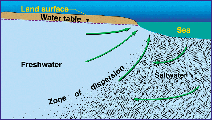 |
| Ground-water flow patterns and the zone of dispersion
in an idealized, homogeneous coastal aquifer. |
|
Freshwater and saltwater mix in the zone of dispersion by
the processes of diffusion and mechanical dispersion. A circulation of
saltwater from the sea to the zone of dispersion and then back to the sea is
induced by mixing within this zone. (Figure modified from Cooper, H. H., 1964,
A hypothesis concerning the dynamic balance of fresh water and salt water in a
coastal aquifer: U.S. Geological Survey Water-Supply Paper 1613-C, p. 1-12).
|
| For more Information, Contact |
Paul Barlow, Coordinator
Atlantic Coastal Zone Assessment
U.S. Geological Survey
10 Bearfoot Road
Northborough, MA 01532
(508) 490-5070
|
|
pbarlow@usgs.gov |
We want your feedback!
|

