Water Resources of the United States


WATER DATA FOR THE NATION

National Water Information System

View current and historical streamflow, ground-water level, and water-quality data

Today's Water Conditions

View comparisons of current and historical conditions using maps
Click map to go to current water resources conditions in the U.S.

WATER SCIENCE SPECIALTIES

WATER SCIENCE BY STATE

USGS Water Science Centers are located in each state

Hydrologic Unit Map
(Based on Data from USGS Water-Supply Paper 2294)
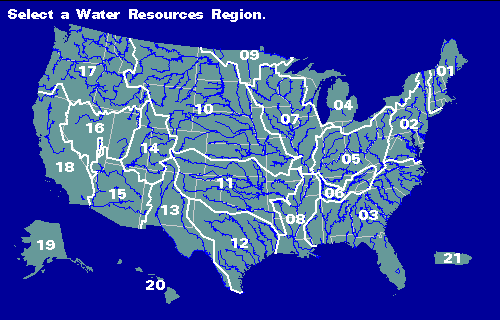

imagemap Region 01 Region 02 Region 03 Region 04 Region 05 Region 06 Region 07 Region 08 Region 09 Region 10 Region 11 Region 12 Region 13 Region 14 Region 15 Region 16 Region 17 Region 18 Region 19 Region 20 Region 21

The gray lines are state lines, the blue lines are major rivers, and the white lines are water-resources region boundary lines.

Region 01 New England
Region 02 Mid-Atlantic
Region 03 South Atlantic-Gulf
Region 04 Great Lakes
Region 05 Ohio
Region 06 Tennessee
Region 07 Upper Mississippi
Region 08 Lower Mississippi
Region 09 Souris-Red-Rainy
Region 10 Missouri
Region 11 Arkansas-White-Red
Region 12 Texas-Gulf
Region 13 Rio Grande
Region 14 Upper Colorado
Region 15 Lower Colorado
Region 16 Great Basin
Region 17 Pacific Northwest
Region 18 California
Region 19 Alaska (Old numbering system)
Region 20 Hawaii
Region 21 Caribbean

USGS Home Core Science Ecosystems Energy and Minerals Environmental Health Land Resources Hazards Water

Accessibility FOIA Privacy Policies and Notices

U.S. Department of the Interior | U.S. Geological Survey

URL: https://water.usgs.gov/GIS/regions.html

Page Contact Information: Water Webserver Team
Page Last Modified: Thursday, 01-Dec-2016 14:32:46 EST