The High Plains aquifer underlies one of the major agricultural areas in the world in parts of Colorado, Kansas, Nebraska, New Mexico, Oklahoma, South Dakota, Texas, and Wyoming. Nearly 30 percent of the ground water used for irrigation in the United States is pumped from the High Plains aquifer (Weeks and others, 1988). In 1990, 15.6 million acre-feet of water was withdrawn from the aquifer to irrigate approximately 14 million acres (Carr and others, 1990).
Water-level declines appeared in the High Plains aquifer soon after extensive ground-water irrigation development first began in about 1940. By 1980, water levels in parts of the Texas High Plains, Oklahoma Panhandle, and southwestern Kansas declined more than 100 feet. In response to these declines, the U.S. Geological Survey (USGS) began an ongoing ground-water monitoring program in 1988 to annually assess water-level change in the aquifer. Numerous Federal, State, and local water-resource agencies, in cooperation with the USGS, currently measure water levels in more than 8,000 wells annually in the High Plains.
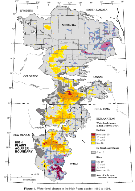
The geographic patterns of water-level change in the High Plains from 1980 to 1994 largely replicate the patterns of change from predevelopment to 1980. Large water-level declines have continued in parts of the Texas High Plains, Oklahoma Panhandle, and southwestern Kansas (fig. 1). Some areas of substantial decline prior to 1980 in the Northern High Plains, however, have generally had either water-level rises or considerably slower rates of decline since 1980. The water-level rises in parts of the eastern High Plains of Nebraska and the extreme southern High Plains of Texas are closely associated with well above normal precipitation in these areas since 1980.
 (Click on image for a larger version, 50 Kbytes).
Figure 1. Water-level change in the High Plains aquifer, 1980 to 1994.
The area-weighted average water level in the High Plains (table 1) declined 1.54 feet from 1980 to 1994--about 0.11 foot annually. This compares to 9.90 feet from predevelopment (1940) to 1980--about 0.25 foot annually. The slower rate of decline since 1980 can be largely attributed to the average water-level rise of 1.88 feet (0.13 foot annually) in Nebraska. The average annual rate of decline in Texas decreased from 0.84 foot, from predevelopment to 1980, to 0.22 foot, from 1980 to 1994. Only in Kansas has the average annual rate of decline been more rapid since 1980--0.33 foot prior to 1980 and 0.44 foot since 1980. The slower rate of decline after 1980 occurred even though the 1980-to-1994 average annual irrigated acreage was more than double (14 million acres) the predevelopment- to-1980 average annual irrigated acreage (6 million acres). The following factors appear to have contributed to the much slower rate of water-level decline in the High Plains after 1980:
                   Area-weighted water-level change (feet)

                      Predevelopment
State                    to 1980          1980 to 1994

Colorado                  -4.20              -3.39
Kansas                    -9.90              -6.12
Nebraska                   0                 +1.88
New Mexico                -9.80              -2.31
Oklahoma                 -11.30              -1.81
South Dakota               0                 +1.47
Texas                    -33.7               -3.02
Wyoming                    0                 -2.52

High Plains               -9.90              -1.54
The area-weighted average water level from 1993 to 1994 rose in the High Plains for a second consecutive year. The 0.56-foot rise from 1993 to 1994 (table 2) was considerably larger than the average rise of 0.21 foot from 1992 to 1993 (Dugan and Cox, 1994). The larger rise may be attributed to precipitation in the High Plains that averaged 4.24 inches above normal in 1993, as compared to 2.03 inches above normal in 1992. The larger rise from 1993 to 1994 also may be associated with the accumulative effect of 3 consecutive years of above-normal precipitation in the High Plains. The area-weighted average precipitation in the High Plains during 1990-93 was 2.49 inches above normal.
Although the area-weighted average water level rose in the High Plains from 1993 to 1994 and the area-weighted average precipitation was well above normal in 1993, these conditions were not uniform across the High Plains (tables 2 and 3). Both water-level change and precipitation presented strongly contrasting regional patterns within the High Plains (fig. 2). Declines exceeding 3 feet extended in a nearly continuous 100-mile arc from eastern New Mexico across the northern part of the Southern High Plains of Texas. The area-weighted average water-level decline was nearly 1 foot in the High Plains of Texas and 0.27 foot in New Mexico (table 2). Precipitation was generally below normal in 1993 in those parts of the Southern and Central High Plains with wide-spread water-level declines from 1993 to 1994 (table 3).
 (Click on image for a larger version, 70 Kbytes).
Figure 2. Water-level change in the High Plains aquifer, 1993 to 1994.
                       Area-weighted
State            water-level change (feet)

Colorado                  -.13
Kansas                    +.55
Nebraska                 +1.81
New Mexico                -.27
Oklahoma                  +.10
South Dakota              +.38
Texas                     -.99
Wyoming                   +.13

High Plains               +.56
                                       Average area-weighted
              Average area-weighted    departure from 30 year     Percentage
State         precipitation (inches)      normal (inches)         of normal

Colorado              17.42                    +1.14                 107
Kansas                28.75                    +7.26                 134
Nebraska              29.38                    +7.87                 137
New Mexico            15.10                    -1.28                  92
Oklahoma              19.44                     -.25                  99
South Dakota          25.69                    +6.98                 137
Texas                 17.56                    -1.37                  93
Wyoming               18.01                    +3.67                 126

High Plains           24.02                    +4.24                 121
Carr, J.E., Chase, E.B., Paulson, R.W., and Moody, D.W., 1990, National water
     summary 1987--Hydrologic events and water supply and use: U.S. Geological Survey
     Water-Supply Paper 2350, 552 p.

Dugan, J.T., and Cox, D.A., 1994, Water-level changes in the High Plains aquifer
     --Predevelopment to 1993: U.S. Geological Survey Water-Resources Investigations
     Report 94-4157, 60 p.

Weeks, J.B., Gutentag, E.D., Heimes, F.J., and Luckey, R.R., 1988, Summary of
     the High Plains regional aquifer-system analysis in parts of Colorado, Kansas,
     Nebraska, New Mexico, Oklahoma, South Dakota, Texas, and Wyoming: U.S. Geological
     Survey Professional Paper 1400-A, 30 p.
--Jack T. Dugan and Jennifer B. Sharpe
from U.S. Department of the Interior, U.S. Geological Survey, Fact Sheet FS-215-95
 html, which you're presently viewing, and
 FS_215-95, 347K
- or for more information on
Portable Document Format
FS_215-95, 347K
- or for more information on
Portable Document Format