
StreamStats FAQ
General Implementation Issues
Who are the members of the StreamStats team?
- Kernell Ries (OSW, kries@usgs.gov, 703-647-5307) is the main contact for questions on StreamStats. Al Rea (Idaho District, ahrea@usgs.gov, 208-387-1323) and Pete Steeves (Massachusetts District, psteeves@usgs.gov, 508-490-5054) are the team's GIS experts. Jacque Coles (Idaho District, jdcoles@usgs.gov, 208-387-1390) is the team's computer and ArcIMS expert.
Why a National application instead of a tool for districts?
- By putting the application on the Web, it becomes a tool for the public as well as for the Districts. We expect the Web application will reduce our information requests and provide users with faster and more consistent data delivery. Districts will be able to use it to develop databases for new regression analyses.
- We are investigating providing a desktop version of StreamStats to the Districts, and possibly to cooperators. The desktop application would have batch capability and possibly some additional functionality that may not be available on the Web. We will not make any commitment to a desktop version until after the prototype Web application is completed. Providing support for a desktop application is a large concern.
What software is being used to develop StreamStats?
- The following ESRI software is being used to develop the application:
- ArcObjects
- ArcGIS ArcInfo 8.2
- Spatial Analyst
- StreetMap
- ArcIMS 4.0
- ArcSDE 8.2
- Programming is being done using MS Visual Basic and XML. A custom connector is being built between the Web server and ArcIMS to allow real-time use of ArcGIS over the Web for measuring the basin and climatic characteristics and solving the regression equations. The National Flood Frequency program, programmed with MS Visual Basic, will solve the regression equations. The StreamStats database is a MS Access database. MS SQL is being used to store the GIS data in a system of geodatabases.
Once the software is developed, is it ours or is it proprietary and will it cost Districts for licensing and maintenance?
- All code specific to StreamStats will be owned by the U.S. government, and will be in the public domain; however, ESRI software used by StreamStats is proprietary. OSW plans to have a single application that will serve information for all Districts that participate in StreamStats. These Districts will not incur any cost for licensing and maintenance of StreamStats. However, a desktop version of StreamStats may be developed after the Web application has been implemented. If the desktop version were made available to the Districts, the Districts would need to pay for licensing and maintenance of ESRI and other software needed to run StreamStats.
What is the schedule for the project?
- There have been several unplanned changes to our approach as GIS software and data availability have changed, leading to some delays. We hope to have the prototype working by the end of 2002.
What level of funding do you expect to send to the Districts?
- The OSW does not have funding available at this time to help Districts implement StreamStats. The OSW is funding the development of the application and helping to fund completion of the national GIS data layers needed to run it. Districts generally will need to rely on cooperative funding to complete the preparations needed to implement StreamStats.
Can States have partial implementations of StreamStats?
- Yes. Both components of StreamStats - the database for data-collection sites and the ungaged site procedure - can be implemented separately. For instance, a District may begin a project to develop new regression equations for use in StreamStats. These projects typically take 2 or 3 years to complete; however, the District may be able to implement the data-collection site functionality of StreamStats during the first year of the project. Also, districts can limit the types of statistics provided in StreamStats to those that are availble from past projects, with the abililty to add new statistics as they become available.
Will the general public have access to StreamStats?
- When users initially enter the StreamStats application, their IP address will be read. Users with external IP addresses will be able get information only for those areas that OSW has approved for general access. Internal users will be able to get information for areas that have not yet been approved for general access. This will allow Districts to test the accuracy of StreamStats before capabilities for their States are made public.
For the flood statistics, do you plan to include the Bulletin17B procedure that weights the regression estimates for gaging stations with estimates determined from the gaged record?
- Yes, this weighting process will also be available for use with other types of streamflow statistics.
What if someone enters their address, estimates a 100-year flood, and finds it doesn't agree with FEMA's flood insurance maps?
- There could be several reasons why this would occur, the most likely being that either older equations than the ones in Streamstats or another technique was used to estimate the 100-year flood used to develop the flood map. In any case, probably the user should contact FEMA if the difference between the estimates is larger than the standard error or the prediction interval presented in StreamStats.
GIS and Basin Characteristics Issues
When will guidance be available for preparing data?
- It is not yet possible to provide complete guidance on the steps that are needed for implementation because the prototype is still under development, and some things may change. We expect that complete guidance will be available by the end of FY2002. Meanwhile, the StreamStats team has been working upon request with several Districts to help them plan for StreamStats implementation.
What DEM's will be used?
- StreamStats is designed to use the best-available DEM's for any given area of the country. In most cases, those will be the NED. In areas where 10-m or other high-resolution data are available, we will be able to use them.
How much is NMD involved with the StreamStats effort?
- NMD has been involved primarily in creating the national GIS data needed for StreamStats to work. We have had extensive discussions with employees at the EROS Data Center and at USGS headquarters on the design of StreamStats and the development of the data. Completion of the EDNA stage 1 data has, in particular, been critical to the development of StreamStats.
How will drainage boundaries for ungaged sites be determined?
- Drainage boundaries will be determined using three GIS data layers: a networked, centerlined, streams; drainage boundaries; and a DEM. Streamstats will have flexibility on the source of these three layers as long as the structure of the data fits requirements that will be provided after the prototype is released. In many areas of the Nation, the EDNA dataset will supply all three layers. In other areas, higher-resolution local data layers will be used.
- Users will select points along the stream network, then the DEM will be used to determine the drainage boundary up to the points at which the DEM-derived boundary intersects boundaries in the drainage-boundary data layer. The closeness of the selected point to previously-digitized boundaries will determine the extent to which the DEM is used.
How will basin characteristics be measured?
- The drainage boundaries and most basin characteristics will be determined using functions derived from the ArcHydro Toolkit, a set of tools that has been developed for GIS data that conforms to the ArcGIS Hydro Data Model. These tools allow for measuring such things as areal averages and sums of selected characteristics.
- In the ArcGIS Hydro Data Model, catchment boundaries are derived to indicate the area that drains to each stream segment, a stream segment being a length of stream with no tributaries. Basin characteristics needed to solve the regression equations for each 8-digit HUC will be pre-determined and saved as attributes to the catchments. Streamstats will determine the basin characteristics for ungaged sites on the fly only for the part of the drainage basin that is upstream from the site but downstream from the next upstream catchment. The basin characteristics for the remainder of the basin will be determined by looking up the values from the attribute tables associated with the upstream catchments.
How are non-contributing areas and Karst areas handled?
- Districts will need to develop data layers to indicate these areas so that the drainage areas for the ungaged sites can be adjusted accordingly.
We tried to use GIS data layers in west-central Florida. We could not match published drainage areas.
- There likely will always be some areas where the automated procedure for measuring drainage areas will not work. Most of these areas have flat topography, and the resolution of the available DEM is not adequate to accurately determine the boundary. Higher resolution DEM's would help in many of these areas. In addition, streams in some areas, including much of Florida, have been channelized and controlled to the extent that natural drainage boundaries determined from DEM's are meaningless. One method to work around this limitation is to finely discritize subbasin boundaries to minimize the extent of application-derived boundaries.
User Interface Issues
How will data-collection sites be identified on the map?
- They will be color-coded according to station type. Clicking on the sites will cause all of the information available for the site to be displayed in a browser window.
Can we add coverages that our cooperators want, such as land use, sewage discharge, water intakes, etc?
- A standard set of national data layers will be available for display as base layesrs in StreamStats, including the DLG digital topographic quadrangles. We would like to be able to display additional local data layers, but we cannot guarantee this ability will be available initially.
Regression Equation Issues
How current will the regional regression equations in StreamStats be? Is there a program to update this periodically?
- We will use the most recent equations available for each State. The OSW cannot dictate when equations should be updated, as development of new equations generally relies on matching funds from cooperators. When Districts produce reports with new equations, they will need to alert the OSW that a change is needed.
Do we have to use GIS data layers for flood frequency or other regression projects already underway?
- No, but if you don't there is no guarantee that it will be possible to serve your equations using StreamStats. If your equations are developed from basin characteristics determined using GIS, putting the equations in StreamStats is straightforward. If they are not, tests will need to be done to determine if the basin characteristics and regression estimates from StreamStats are equivalent to those obtained for sites used in your regression analyses. If the results are not equivalent, your equations cannot be served by StreamStats. It will be District responsibility to do the tests and provide documentation to the OSW, thus this cost should be factored in when deciding whether or not to use GIS to measure the basin characteristics for your study.
Will Streamstats be able to solve any form of regression equation?
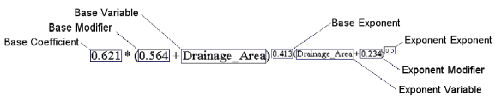
- StreamStats will be able to solve standard-format regression equations typically developed using OLS, WLS, or GLS procedures. A simple example of such an equation has four components, and takes the form
- where the first component is Q, the flow statistic for an ungaged site; the second component is a, the base coefficient; the third component is X, Y, and Z, the physical or climatic variables; and the fourth component is b, c, and d, the exponents. StreamStats will allow somewhat more elaborate equations with seven components.
- Each base variable can have a constant base modifier. In addition, each exponent can be modified by an exponent variable, an exponent modifier, and an exponent exponent, as shown above.
- Work is in progress to add the ability to solve region-of-influence equations to StreamStats. We hope to have this completed by the end of calendar year 2002.
What about urban equations?
- StreamStats will not be able to solve the national urban equations or any local urban equations that use the Basin Development Factor (BDF) as an explanatory variable. This is because there is no GIS process available for measuring this variable.
How will StreamStats handle regulation?
- Nearly all USGS regression equations were developed using sites with natural flow conditions, thus the estimates obtained from the equations are for natural flow. At least initially, StreamStats will not be able to estimate the effects of regulation on streamflow. We are investigating use of proration of the flow per unit area at gaged sites on large regulated rivrers to estimate flows at ungaged sites upstream from, downstream from, or between the gaged sites.
Data-Collection Site Database Issues
Where will the Access database for data-collection sites reside, on a national webserver or district servers/webservers?
- Each District will need to download a copy of the database and populate it with their sites. The Districts will then need to send a completed copy of the database to the Office of Surface Water, where it will be merged with the other District databases to create a single national database for use by StreamStats. Districts will be able to send the OSW updated versions of their database whenever necessary. The national database will be served over the web by the StreamStats server in Idaho.
When will the database be distributed?
- We hope to have it available for download from the StreamStats web site by the end of July 2002.
