Water Resources of the United States
The following documentation was taken from:
U.S. Geological Survey Water-Resources Investigations Report 94-4002:
Nationwide summary of U.S. Geological Survey regional regression equations for
estimating magnitude and frequency of floods for ungaged sites, 1993
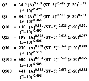
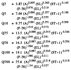
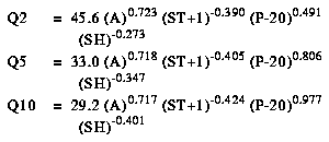
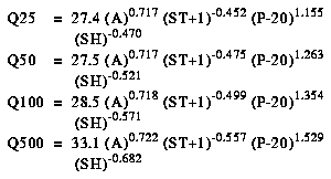
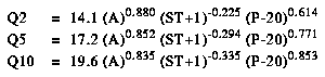
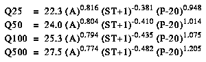
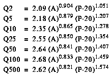
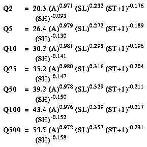
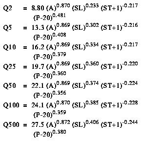
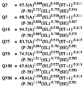
New York, exclusive of Long Island, is divided into eight hydrologic regions (fig. 1). The regression equations developed for these regions are for estimating peak discharges (QT) having recurrence intervals T that range from 2 to 500 years. The explanatory basin variables used in the equations are drainage area (A), in square miles; basin storage (ST), the percentage of the drainage area shown as lakes, ponds, or swamps on topographic maps; mean annual precipitation (P), in inches; main-channel slope (SL), in feet per mile; basin forest cover (F), as a percentage of the total drainage area; average main-channel elevation (EL), in feet, computed as the average of the elevations at points located 10 and 85 percent of the channel length upstream from the gage; and basin shape index (SH), computed as the ratio of the square of the main-channel stream length, in miles, to drainage area, in square miles. The constants 5, 1, -20, and 10 are added to St, P, and F in the computer application of the regression equations. The user should enter the actual values of St, P, and F. All the variables except P can be measured from topographic maps; P can be obtained from figure 2. The regression equations were developed from peak-discharge records available as of 1987 at 313 stations (29 of which were in adjacent States) with the equations applicable only to unregulated, rural streams in New York, excluding Long Island. The standard errors of prediction of the regression equations range from 17 to 51 percent. The report by Lumia (1991) also includes basin and flood-frequency characteristics and maximum known discharges at gaging stations. Alternative regression equations based only on drainage area are also included in Lumia (1991).
Topographic maps, the hydrologic regions map (fig. 1), the mean annual precipitation map (fig. 2), and the following equations are used to estimate the needed peak discharges QT, in cubic feet per second, having selected recurrence intervals T.
Lumia, R., 1991, Regionalization of flood discharges for rural, unregulated streams in New York, excluding Long Island: U.S. Geological Survey Water-Resources Investigations Report 90-4197, 119 p.
Stedfast (1986) investigated the applicability of six methods of estimating urban flood-frequency characteristics at 11 urban watersheds in New York. The conclusion was that the urban equations described in Sauer and others (1983) yielded the smallest standard errors and bias in relation to flood peaks based on a rainfall-runoff model at the 11 urban watersheds. The method of Sauer and others (1983) is available in the NFF Program.
Stedfast, D.A., 1986, Evaluation of six methods for estimating magnitude and frequency of peak discharges on urban streams in New York: U.S. Geological Survey Water-Resources Investigations Report 84-4350, 24 p.
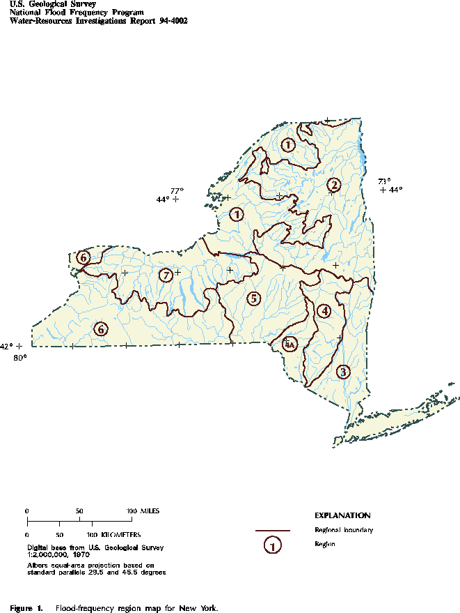
Figure 1. Flood-frequency region map for New York. (PostScript file of Figure 1.)
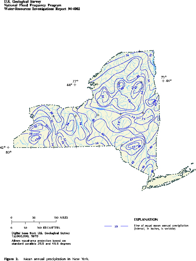
Figure 2. Mean annual precipitation in New York. (PostScript file of Figure 2.)
Accessibility FOIA Privacy Policies and Notices
![]() U.S. Department of the Interior | U.S. Geological Survey
U.S. Department of the Interior | U.S. Geological Survey
URL: https://water.usgs.gov/software/NFF/manual/ny/
[an error occurred while processing this directive]
Page Contact Information: pacampbe@usgs.gov
Page Last Modified: Thursday, 06-Mar-2014 09:35:51 EST
