Water Resources of the United States
The following documentation was taken from:
U.S. Geological Survey Water-Resources Investigations Report 94-4002:
Nationwide summary of U.S. Geological Survey regional regression equations for
estimating magnitude and frequency of floods for ungaged sites, 1993
New Hampshire is considered to be one hydrologic region. The regression equations developed for the State are for estimating peak discharges (QT) having recurrence intervals T that range from 2 to 100 years. The explanatory basin variables used in the equations are drainage area (A), in square miles; channel slope (S), in feet per mile; and the 2-year 24-hour precipitation (I2,24), in inches. The variables A and S can be measured from topographic maps, and I2,24 taken from the U.S. Weather Bureau Technical Paper (TP) 29 is shown (fig. 1).
The regression equations were developed from peak-discharge records for 59 stations. The equations are applicable to streams whose flows are not significantly affected by regulation, diversion or urbanization, and whose drainage areas are between 0.27 and 622 square miles. The standard errors of estimate of the regression equations range from 35 to 58 percent. The report by LeBlanc (1978) also includes selected basin and flood characteristics for gaging stations.
Topographic maps, the 2-year 24-hour precipitation map (fig. 1), and the following equations are used to estimate the needed peak discharges QT, in cubic feet per second, having selected recurrence intervals T.
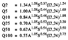
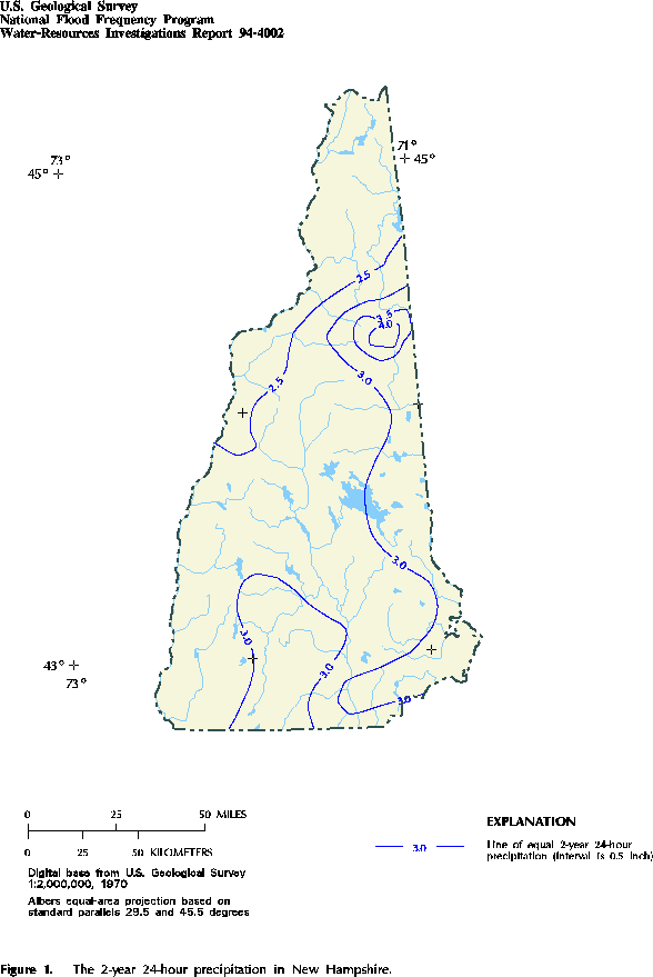
Figure 1. The 2-year 24-hour precipitation in New Hampshire. (PostScript file of Figure 1.)
Accessibility FOIA Privacy Policies and Notices
![]() U.S. Department of the Interior | U.S. Geological Survey
U.S. Department of the Interior | U.S. Geological Survey
URL: https://water.usgs.gov/software/NFF/manual/nh/
[an error occurred while processing this directive]
Page Contact Information: pacampbe@usgs.gov
Page Last Modified: Thursday, 06-Mar-2014 09:35:51 EST
