Water Resources of the United States
The following documentation was taken from:
U.S. Geological Survey Water-Resources Investigations Report 94-4002:
Nationwide summary of U.S. Geological Survey regional regression equations for
estimating magnitude and frequency of floods for ungaged sites, 1993
Michigan is divided into five hydrologic regions (fig. 1). The regression equations developed for these regions are for estimating peak discharges (QT) having recurrence intervals that range from 5 to 100 years. The explanatory basin variables used in the equations are contributing drainage area (CONTDA), in square miles; main-channel slope (SLOPE), in feet per mile; main-channel swamp (CHSWAMP), which is the percentage of main-channel length that passes through swamp, lake, or pond; slenderness ratio (SLENRAT), which is the square of channel length divided by the contributing drainage area; the 100-year 24-hour rainfall (I24-100), in inches; 7 characteristics of surficial geologic material and a regional factor (Rf). The surficial geologic variables are CLAY, lacustrine clay and silt, as a percentage of CONTDA; CORGT, coarse-textured glacial till, as a percentage of CONTDA; FINEM, end moraines of fine-textured till, as a percentage of CONTDA; MEDTILL, medium-textured glacial till and end moraines of medium-textured glacial till, as a percentage of CONTDA; MUCK, peat and muck, as a percentage of CONTDA; OUTWASH, postglacial alluvium, glacial outwash sand and gravel and postglacial alluvium, and ice-contact outwash sand and gravel, as a percentage of CONTDA; and TILROCK, thin to discontinuous glacial till over bedrock, as a percentage of CONTDA. The constant 1 is added to all the surficial geology variables in the computer application of the regression equations. The user should enter the actual values of these variables. The first four variables can be measured from topographic maps, I24-100 is determined from figure 2 and the regional factor (Rf) is determined from figure 1. The surficial geologic variables can be determined from geologic maps by Farrand and Bell (1984). The regression equations were developed from peak-discharge records available through 1982 from 185 stations with 10 or more years of record and are applicable to unregulated and unurbanized streams draining less than 1,000 square miles. The standard errors of estimate of the regression equations range from 30 to 39 percent. The report by Holtschlag and Croskey (1984) includes procedures for estimating mean and mean monthly flows, 5 points on the flow-duration curve, and 7-day and 30-day, 10-year low flows. The report also includes computed and estimated mean and mean monthly flow values, flow duration and low flow values, peak flow and flood volume values, physical, climatological and surficial geologic basin characteristics for all gaging stations in the analysis.
Topographic maps, the hydrologic regions map (fig. 2), the 100-year 24-hour precipitation (fig. 2) and the geologic characteristics from the maps in the report by Farrand and Bell (1984), and the following equations are used to estimate the needed peak discharge QT, in cubic feet per second, having the selected recurrence intervals T.
| Q5 | = | 4.863 CONTDA0.893 SLOPE0.216 CHSWAMP-0.174 SLENRAT-0.115 I24.1001.046 OUTWASH-0.152 MUCK0.167 FINEM0.102 MEDTILL0.088 CLAY0.090 TILROCK0.096 CORGT0.040 Rf |
| Q10 | = | 4.664 CONTDA0.890 SLOPE0.226 CHSWAMP-0.175 SLENRAT-0.124 I24.1001.194 OUTWASH-0.155 MUCK0.166 FINEM0.110 MEDTILL0.100 CLAY0.100 TILROCK0.090 CORGT0.044 Rf |
| Q25 | = | 4.073 CONTDA0.888 SLOPE0.237 CHSWAMP-0.174 SLENRAT-0.135 I24.1001.408 OUTWASH-0.156 MUCK0.167 FINEM0.119 MEDTILL0.112 CLAY0.109 TILROCK0.083 CORGT0.049 Rf |
| Q50 | = | 3.605 CONTDA0.886 SLOPE0.246 CHSWAMP-0.174 SLENRAT-0.141 I24.1001.566 OUTWASH-0.157 MUCK0.168 FINEM0.125 MEDTILL0.118 CLAY0.114 TILROCK0.078 CORGT0.052 Rf |
| Q100 | = | 3.116 CONTDA0.885 SLOPE0.256 CHSWAMP-0.173 SLENRAT-0.149 I24.1001.730 OUTWASH-0.157 MUCK0.170 FINEM0.131 MEDTILL0.124 CLAY0.118 TILROCK0.074 CORGT0.054 Rf |
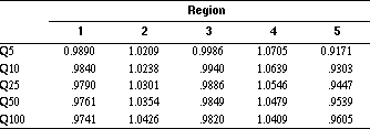
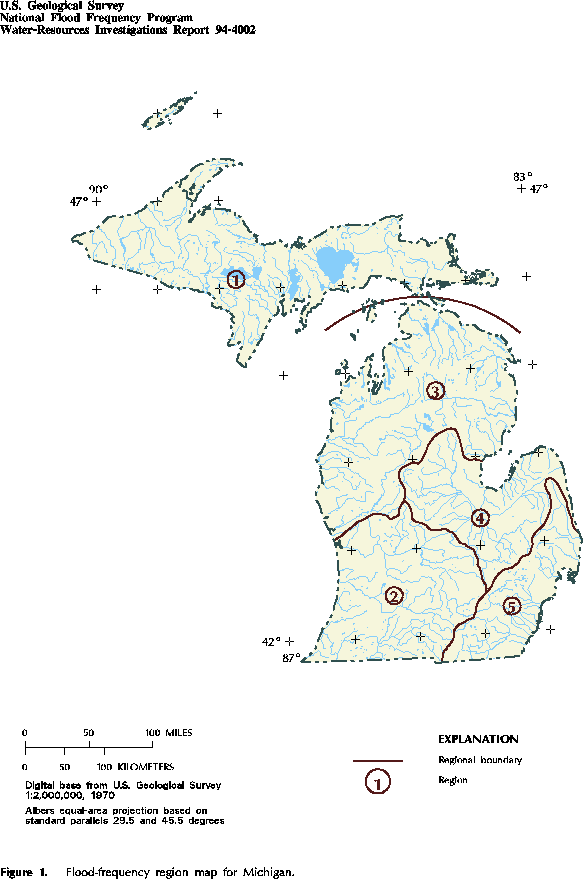
Figure 1. Flood-frequency region map for Michigan. (PostScript file of Figure 1.)
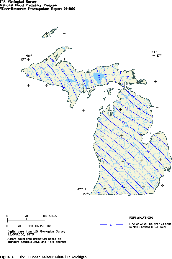
Figure 2. The 100-year 24-hour rainfall in Michigan. (PostScript file of Figure 2.)
![]() U.S. Department of the Interior |
U.S. Geological Survey
U.S. Department of the Interior |
U.S. Geological Survey
URL: https://water.usgs.gov/software/NFF/manual/mi/
[an error occurred while processing this directive]
Page Contact Information: pacampbe@usgs.gov
Page Last Modified: Thursday, 06-Mar-2014 09:35:50 EST
URL: https://water.usgs.gov/software/NFF/manual/mi/
Page Contact Information: NatWeb Team (GS_Help_Natweb@usgs.gov)
Page Last Modified: Thursday, 06-Mar-2014 09:35:50 EST
