Water Resources of the United States
The following documentation was taken from:
U.S. Geological Survey Water-Resources Investigations Report 94-4002:
Nationwide summary of U.S. Geological Survey regional regression equations for
estimating magnitude and frequency of floods for ungaged sites, 1993
In 2001, a single new equation was developed for estimating peak discharges at any recurrence interval for rural ungaged sites in Massachusetts. The new Massachusetts rural equation is documented in the following two reports:
Murphy, P.J., 2001, Evaluation of mixed-population flood-frequency analysis: Journal of Hydrologic Engineering, v. 6, no. 1, p. 62-70
Murphy, P.J., 2001, Estimating equation for mixed populations of floods in Massachusetts: Journal of Hydrologic Engineering, v. 6, no. 1, p 72-74
The form of the new Massachusetts equation is not compatible with NFF, version 3; therefore, it is not included in the program. Because of its complexity, a computer program is required to solve the new equation. Until a separate program can be provided to solve the new equation or NFF can be modified to solve the equation, users should continue to use the equations previously developed by Wandle (1983), which are included in NFF, version 3. The documentation below for Wandle’s equations is taken from:
Jennings, M.E., Thomas, W.O., Jr., and Riggs, H.C., 1994, Nationwide Summary of U.S. Geological Survey Regional Regression Equations for Estimating Magnitude and Frequency of Floods for Ungaged Sites, 1993: U.S. Geological Survey Water-Resources Investigations Report 94-4002, 196 p.
Massachusetts is divided into three hydrologic regions (fig. 1). The regression equations developed for these regions are for estimating peak discharges (QT) having recurrence intervals T that range from 2 to 100 years. The explanatory basin variables used in the equations are drainage area (A), in square miles; basin storage (St), as a percentage of the basin area; main-channel slope (Sl), in feet per mile; and mean basin elevation (E), in feet. The constant 0.5 is added to St in the computer application of the regression equations. The user should enter the actual value of St. All of these variables can be measured from topographic maps. The regression equations were developed from peak-discharge records available at 95 sites. The regression equations are applicable to streams draining between 0.25 and 260 square miles, which are unaffected by regulation or appreciable manmade storage. Standard errors of estimate of the regression equations are: Eastern Region, 44 to 52 percent; Central Region, 25 to 41 percent; and Western Region 27 to 45 percent. The report by Wandle (1983) includes flood characteristics at 95 gaged sites.
Topographic maps, the hydrologic regions map (fig. 1), and the following equations are used to estimate the needed peak discharges QT, in cubic feet per second, having selected recurrence intervals T.
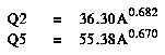
Merrimack River basin, Coastal river basins (Parker River to Ten Mile River excluding basins in eastern Plymouth County)
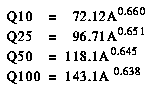
Blackstone River basin, French River basin, Quinebaug River
basin, Millers River basin, Chicopee River basin and minor basins
draining into the Connecticut River from the east side.
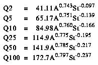
Deerfield River basin, Westfield River basin and minor basins
draining into the Connecticut River from the west, Housatonic
River basin, Hoosic River basin
Wandle, S.W., 1983, Estimating peak discharges of small, rural streams in Massachusetts: U.S. Geological Survey Water-Supply Paper 2214, 26 p.
![]()
Figure 1. Flood-frequency region map for Massachusetts. (PostScript file of Figure 1.)
![]() U.S. Department of the Interior |
U.S. Geological Survey
U.S. Department of the Interior |
U.S. Geological Survey
URL: https://water.usgs.gov/software/NFF/manual/ma/
[an error occurred while processing this directive]
Page Contact Information: pacampbe@usgs.gov
Page Last Modified: Thursday, 06-Mar-2014 09:35:50 EST
URL: https://water.usgs.gov/software/NFF/manual/ma/
Page Contact Information: NatWeb Team (GS_Help_Natweb@usgs.gov)
Page Last Modified: Thursday, 06-Mar-2014 09:35:50 EST
