Water Resources of the United States
The following documentation was taken from:
U.S. Geological Survey Water-Resources Investigations Report 94-4002:
Nationwide summary of U.S. Geological Survey regional regression equations for
estimating magnitude and frequency of floods for ungaged sites, 1993
Illinois is divided into four hydrologic regions (fig. 1), each of which is assigned a regional factor. The regression equations developed for these regions are for estimating peak discharges (QT) having recurrence intervals T that range from 2 to 500 years. The explanatory basin variables used in the equations are drainage area (A), in square miles; main-channel slope (S), in feet per mile; rainfall (I), in inches, which is the 2-year 24-hour precipitation (fig. 2); and a regional factor (Rf). The constant 2.5 is subtracted from I in the computer application of the regression equations. The user should enter the actual value of I from figure 2. The variables A and S can be measured from topographic maps and I can be determined from figure 2. The regional boundaries can be determined from figure 1 and a table of regional factors (Rf) is given below. The regression equations were developed from peak-discharge records for 268 gaged sites in Illinois, Indiana, and Wisconsin. The regression equations are applicable to streams with drainage areas ranging from 0.02 to 10,000 square miles. Standard errors of prediction for the regression equations range from 35 to 50 percent. The report by Curtis (1987) also includes graphical relations of flood characteristics to drainage area for the regulated Big Muddy, Fox, and Illinois Rivers.
Topographic maps, the hydrologic regions map (fig. 1), the table of regional factors (Rf), the 2-year 24-hour precipitation map (fig. 2), and the following equations are used to estimate the needed peak discharges QT, in cubic feet per second, having selected recurrence intervals T.
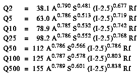
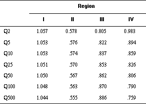
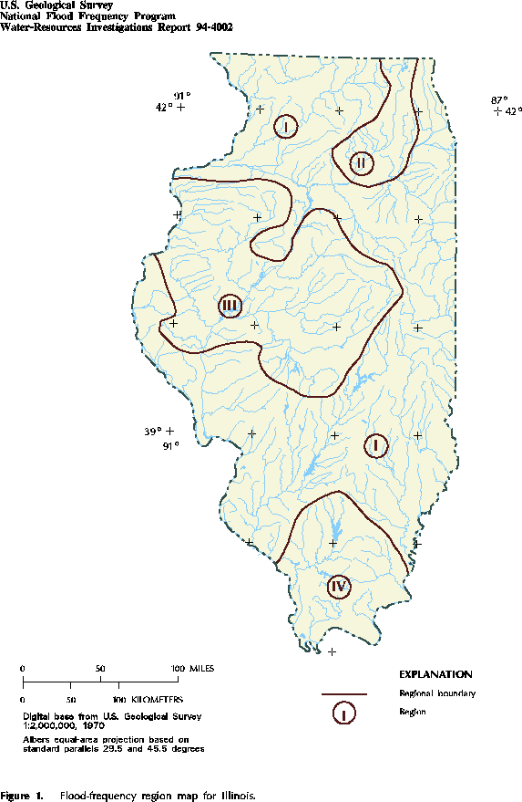
Figure 1. Flood-frequency region map for Illinois. (PostScript file of Figure 1.)
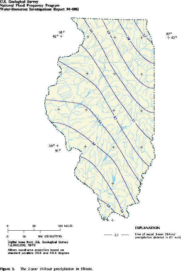
Figure 2. The 2-year 24-hour precipitation in Illinois. (PostScript file of Figure 2.)
![]() U.S. Department of the Interior |
U.S. Geological Survey
U.S. Department of the Interior |
U.S. Geological Survey
URL: https://water.usgs.gov/software/NFF/manual/il/
[an error occurred while processing this directive]
Page Contact Information: pacampbe@usgs.gov
Page Last Modified: Thursday, 06-Mar-2014 09:35:50 EST
URL: https://water.usgs.gov/software/NFF/manual/il/
Page Contact Information: NatWeb Team (GS_Help_Natweb@usgs.gov)
Page Last Modified: Thursday, 06-Mar-2014 09:35:50 EST
