|
|
For more than 100 years the U.S. Geological Survey (USGS) has been
assessing, mapping, and reporting on New Hampshire's natural resources and
natural hazards. Ongoing USGS programs in New Hampshire include
topographic and geologic mapping, surface- and ground-water resource
assessment and data collection, water-quality assessments, research on
movement of water and toxic substances in aquifer systems assessment of
hydrologic and geologic hazards, mineral exploration, and assessment of
biologic resources. Through cooperative programs with many State and local
agencies, the USGS contributes to the health, safety, and economic well
being of New Hampshire's citizens. |

|
|
Maps and digital cartographic data are used by many people for various
commercial and recreational purposes. Among the most popular and versatile
products of the USGS are its 1:24,000-scale topographic maps (1 inch on the
map represents 2,000 feet on the ground). These maps depict natural and
cultural features of the landscape, such as lakes and streams, highways and
railroads, boundaries, and geographic names. Contour lines are used to
depict the elevation and shape of the terrain. New Hampshire is covered by
215 maps at this scale.
The USGS, through its National Mapping Program, fosters partnerships with
State and Federal agencies to improve the effectiveness of its
data-collection activities, to share resources, and to enhance the
availability of timely and accurate data. The USGS and the New Hampshire
Office of State Planning are involved in two cooperative projects. The
first is to create digital raster graphic (DRG) files for the entire State;
DRG's are scanned and digitized images of USGS topographic maps. The USGS
is producing DRG's of the 1:24,000-, 1:100,000-, and 1:250,000-scale
topographic map series. The final product will be available on CDĐROM. The
second cooperative project is to produce digital line graphic files of
topography in support of the Route 16 Transportation Initiative. The USGS
also provides stable base-map materials so that USGS base maps can be
reproduced easily by State agencies.
|
Through the Competitive Cooperative Agreements Program, the USGS and the
State of New Hampshire, as well as five other New England States, have
formed a national spatial data base "clearinghouse." This clearinghouse is
located at the University of Massachusetts and supplies geographic and
cartographic data from the States to the public through the World-Wide Web
(www). Consolidated spatial data from this source will improve the
services in such areas as emergency planning, environmental assessment,
resource inventories, and resource-quality analyses that are provided to
the residents of New Hampshire. |
|
|
|
Increases in population and development in New Hampshire have increased
water-supply demands. Towns and communities are interested in developing
additional ground-water supplies and in protecting existing water resources
for the future. In 1984, the New Hampshire Department of Environmental
Services, Water Division, entered into a long-term cooperative program with
the USGS to assess the State's ground-water resources. Under this program,
the USGS has identified and described the State's principal sand and gravel
aquifers and is currently (1996) assessing the ground-water supply
potential of the fractured-bedrock aquifers.
The areal extent, geohydrologic properties, potential water yield, and
quality of water in sand and gravel aquifers are presented in a series of
maps and reports of 13 study areas that cover the State. The location of
major sand and gravel aquifers and areas of potentially high water yield
are shown in figure 1.
|
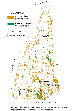
(Click on image for a larger version, 50K GIF)
|
|
Figure 1. Location of major sand and gravel aquifers and
areas of potentially high water yield in New Hampshire. |
In 1995, the focus of the cooperative program shifted to an assessment of
the State's fractured-bedrock aquifers. This phase of the program is
designed to identify areas of potentially high water yield and to determine
the quality of the water from these sources. The results of this study
will provide information useful to communities and to regional and State
planners in the development of water supplies and the management of
programs to protect aquifers. |
|
|
|
At some sites in New Hampshire, ground water contains hazardous-waste
chemicals in concentrations that may threaten human health and the
environment. Federal and State agencies responsible for regulating the
cleanup of these sites need ground-water flow information to predict
patterns of movement and the ultimate fate of contaminants.
The USGS, in cooperation with the U.S. Environmental Protection Agency, is
investigating the movement of contaminants in ground- and surface-water
systems and is providing technical assistance at a number of
hazardous-waste sites in southern New Hampshire.
|
In Milford, the USGS has been studying the influence of ground-water flow
on the movement of dissolved volatile organic compounds in a sand and
gravel aquifer. Two municipal supply wells were closed as the result of
contamination. The USGS has constructed computer models of ground-water
flow to simulate various hydrologic conditions, such as recharge from
precipitation, ground-water withdrawals, and streamflow. Simulations of
variable hydrologic conditions and their effect on ground-water flow can
assist Federal and State regulatory agencies with the management of
contaminated water. An example of simulated paths of ground-water flow
from a contamination source is shown in figure
2.

(Click on image for a larger version, 66K JPEG)
|
|
Figure 2. Paths of ground-water flow in 1988 in Milford,
New Hampshire. | |
|
|
|
In 1990, the USGS began research investigations of the ground-water
movement in fractured bedrock at the Mirror Lake watershed in Grafton
County. This research is designed to address the Nation's need for
accurate and efficient methods of evaluating the movement of contaminants
in fractured-bedrock aquifers.
|
Because ground-water flow in bedrock is predominantly through fractures,
there is a fundamental need to locate and describe fractures. Various
tools that are used to describe fractures, such as borehole imaging cameras
and an acoustic televiewer, are being tested, and the accuracy of the
resulting data is being evaluated. The data collected with these tools are
being used to develop a relation between the geologic characteristics of
the surrounding rock and the hydraulic properties of the rock. After
accurate methods are developed, the results can be used on a local scale to
locate water-bearing fractures that may be capable of transporting
contaminants. On a regional scale, such methods can be used to predict
volumes and rates of ground-water flow. Understanding ground-water flow on
a regional scale is important for planning and protecting water supplies
and assessing strategies for containing and restoring contaminated ground
water. |
|
|
|
The USGS, in cooperation with the New Hampshire Departments of Resources
and Economic Development and of Environmental Services, has produced
detailed maps of surficial geology that show the distribution of sand,
gravel, silt, clay, and till (unsorted sand, gravel, silt, and clay) mostly
in the southern part of the State. This mapping is supported by statemap,
which is an external funding opportunity of the National Cooperative
Geologic Mapping Program. The program addresses a wide variety of economic
and environmental issues by supporting geologic mapping projects in New
Hampshire. These issues include forecasting resource management in the
sand and gravel industry, ground-water management, transportation
engineering, and radon distribution.
In the southern part of the State, where population growth has been rapid,
overview maps of the sand and gravel resources at the 1:250,000 scale also
have been produced. These maps are used extensively by State and local
planning agencies and consultants to address environmental issues related
to water supplies, waste disposal, construction of highways, and building
development.
|
The USGS, in cooperation with the U.S. Department of Energy and the State
of New Hampshire, has compiled a new bedrock geologic map of the State. It
is being prepared for publication by the USGS and includes the bedrock
geologic map at a scale of 1:250,000 and three geologic maps at a scale of
1:500,000. |
|
|
|
The USGS is preparing an inventory of known mineral resources in New
Hampshire and is evaluating areas for undiscovered deposits of gold,
silver, copper, lead, and zinc. Like many Eastern States, New Hampshire
also is dependent on diminishing resources of locally derived minerals and
materials that are required for the maintenance and construction of its
buildings and infrastructure. The USGS is assessing the nonmetallic
mineral resources of the State and providing geologic information that will
assist Federal and State land management agencies, regional planners,
industry, and local governments in planning for the most environmentally
sound and economically viable minerals-related development.
The USGS has two mineral data basesŃthe Mineral Resources Data System and
the Mineral Availability System, which was transferred from the Bureau of
MinesŃthat contain information on deposits and mineral-processing locations
around the world. They are the principal tools that the USGS uses for many
different types of mineral studies, which include resource assessments and
the effect of abandoned mines on the environment. The data bases, which
contain mineral information on about 200 sites in New Hampshire, are
available to Federal and State agencies and the general public in CD-ROM
format.
|
In 1995, New Hampshire ranked 47th in nonfuel mineral production. The
leading non-fuel mineral industry, construction sand and gravel, generated
$36 million and accounted for about two-thirds of the State's production.
Crushed stone, clay, and gemstones were included in the remaining
one-third. |
|
|
|
In 1991, the USGS began a National Water-Quality Assessment (NAWQA) Program
to describe the quality of the Nation's water resources and to identify the
natural and manmade factors that affect it. The program provides
information that is useful to water-resource policy-makers and managers at
national, state, and local levels.
A committee of representatives from Federal, State, and local agencies;
universities; and the private sector works closely with the USGS in each
NAWQA study unit to exchange information on water-quality issues and to
assist in designing and planning project products to meet the needs of the
States and towns in each study unit.
New Hampshire is included in two NAWQA study areas. The New England
Coastal Basins study area encompasses 22,900 square miles that includes
central and eastern New Hampshire, western and central Maine, eastern
Massachusetts, and most of Rhode Island. In New Hampshire, this area
includes the drainage basins of the Merrimack, the Androscoggin, and the
Saco Rivers, as well as small coastal drainage basins. The Connecticut
River and Long Island Sound Coastal Rivers study area encompasses 15,750
square miles that includes western New Hampshire, eastern Vermont,
west-central Massachusetts, most of Connecticut, and small parts of New
York and Rhode Island. In New Hampshire, this area includes the drainage
basin of the Connecticut River. Most of the data have been collected for
the Connecticut River study area, and examples of some of the findings
include the following:
|
Nutrient concentrations, which indicate the health of rivers, ponds, and
lakes, differed among sampling locations but appeared neither excessive nor
indicative of excessive levels of plant materials in water bodies.
Nutrient concentrations determined for urban and agricultural sites were
higher than those determined for undeveloped areas.
The highest concentrations of pesticides were in storm runoff that follows
spring applications; however, concentrations barely exceeded detection
limits. Atrazine, which is a common agricultural herbicide, was detected
at 7 of the 10 sites sampled. Pesticides were not detected in undeveloped
areas. |
|
The Biological Resources Division (formerly the National Biological
Service) is participating in the Connecticut River Ecosystem Initiative,
which highlights an ecosystem approach to resource management. Activities
include incorporating biological data into a geographic information system,
inventorying existing barriers to Atlantic salmon migrations, and mapping
the distribution of fish populations. A map of the plant and animal
communities in the State is being developed in cooperation with the New
Hampshire Office of Special Programs, the White Mountains National Forest,
and other partners. |
|
|
|
The evaluation of stream stability and erosion at bridge sites in New
Hampshire contributes to the improved safety of the State's transportation
system and enhances the knowledge of erosion processes at bridge settings
typical of those found in the Northeast. Nationally, the erosion of
streambeds and riverbanks by floodwaters is the leading cause of failures
of bridges over water.
|
The USGS, in cooperation with the New Hampshire Department of
Transportation, is completing an evaluation of the methods used to estimate
erosion potential and stream-channel stability at 48 susceptible bridge
sites. The evaluation includes a detailed survey and an assessment of the
hydrologic and geomorphologic settings of the bridges. It also includes an
assessment of the appropriateness and accuracy of the methods, equipment,
and procedures that are used to collect erosion data. The accuracy of
predicted erosion compared with measured scour is being determined and
alternative techniques of estimating erosion at the bridge sites are being
identified. |
|
|
|
Water resources in New Hampshire are increasingly stressed by new demands.
To minimize the impact of changing patterns of water use, available
supplies and current and predicted demands need to be evaluated carefully.
Without adequate information, planners are not equipped to resolve critical
issues related to water supply, hydropower, snow making, water quality, and
the potential effects of withdrawals on ecosystems.
The USGS, in cooperation with the New Hampshire Department of Environmental
Services, Water Division, is working to improve the State's water-use
information. Assistance is provided to the State in the collection,
analysis, and dissemination of water-use data. Work is underway to develop
a statewide water-use data base that includes site-specific data and data
aggregated by county and major drainage basins. These data are used to
produce reports which are dis-tributed to Federal and State agencies,
educators, consultants, and other organizations or individuals concerned
with water resources. A report on wastewater in New England and a map
report on freshwater withdrawals and use in New Hampshire have been
produced as part of this program. A graph showing total freshwater use
(excluding hydroelectric instream use) in New Hampshire is shown in figure 3.
|

(Click on image for a larger version, 66K JPEG)
|
|
Figure 3. Total freshwater use in New Hampshire by
category, in 1990. | |
|
|
|
The amount of water in New Hampshire's rivers, streams, lakes, and
reservoirs is measured and monitored by the USGS hydrologic data-collection
program. The data are used by water-resource managers and planners for
forecasting floods and droughts; water-resources planning; design and
operation of projects for water supply, hydroelectric power, flood control,
and pollution control; designing bridges and culverts; flood warning;
flood-plain management; and hydrologic research. Long-term records are
needed to evaluate the responses of hydrologic systems to natural climatic
variations and human-induced stresses so that potential problems can be
defined early and appropriate planning and management actions can be taken
by State and local agencies. Streamflow monitoring also provides baseline
data on natural seasonal discharge variations of rivers and streams (fig. 4).

(Click on image for a larger version, 50K GIF)
|
|
Figure 4. A technician measures the velocity and volume of
streamflow in the Lamprey River. |
|
In New Hampshire, surface-water data are collected from a network of 57
stations. The ground-water monitoring network provides monthly water-level
data at 24 wells. These networks are operated cooperatively by the USGS
and the New Hampshire Department of Environmental Services, Water Division.
Records are published monthly and annually. These data are used routinely
by private consultants, residents, newspapers, colleges and universities,
and local government agencies throughout the State.
Realtime streamflow data are available at 37 locations throughout New
Hampshire by means of satellite and telephone telemetry. This information
is critical for the flood forecasting and response activities of the
National Weather Service and the New Hampshire Emergency Management Agency.
Telemetry data also allow State personnel to monitor drought conditions and
compliance of flow-regulating projects. Realtime data from some of the
stations also are available on the USGS District office www home
page. |
|
The Earth Science Information Centers (ESIC's) provide information about
USGS programs, products, and technological developments to the public. The
ESIC in New Hampshire was established in cooperation with the Dimond
Library of the University of New Hampshire in Durham. As part of the
national ESIC network, this office provides information on such topics as
cartography, geography, biology, digital data, remote sensing, geology,
geophysics, geochemistry, hydrology, geohydrology, aerial photography, and
land use. It is supported by the USGS with reference materials, technical
assistance, training and outreach activities, and access to USGS data
bases.
|