In Reply Refer To:
Mail Stop 415
January 4, 1999
OFFICE OF SURFACE WATER TECHNICAL MEMORANDUM NO. 99.02
SUBJECT: U.S. Geological Survey Historical Daily-Value Suspended-
Sediment and Ancillary Data on the World Wide Web
This memorandum announces a World Wide Web (Web) data base containing historical daily-value suspended-sediment and ancillary data collected at U.S. Geological Survey (USGS) gaging stations. The address of the Web site, developed by USGS hydrologist
Randy Parker, is:
http://webserver.cr.usgs.gov/sediment
BACKGROUND AND DESCRIPTION
Research and monitoring of fluvial-sediment transport by the USGS to address a variety of objectives have provided many years of daily suspended-sediment data at selected USGS streamflow gaging stations. Although neither placement nor operation of the stations providing these data were nationally coordinated, they nonetheless provide substantial information on suspended-sediment discharges and related information collected by uniform protocols (Edwards and Glysson, 1998). The daily suspended-sediment and ancillary data from these stations have been assembled in a data base and are available on the Web. The intended primary audience for this Web site is hydrologists, geomorphologists, and others interested in the spatial distribution, magnitude, and timing of selected suspended-sediment discharges at gaging stations operated by the USGS. The data base was developed through a synthesis of results derived through the Federal-State Cooperative Water Program.
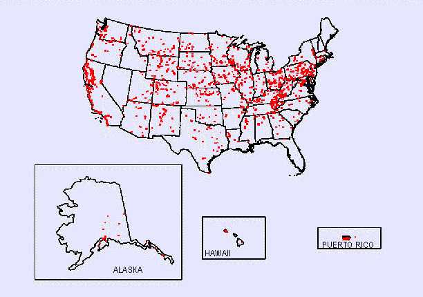
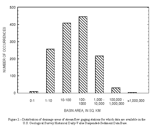
The data base includes 1,593 stations (fig. 1) that have an average period of daily suspended-sediment record of 5.3 years. The period of record for individual stations ranges from 1 day to 44 years, with 13 percent of the stations having a decade or more of daily suspended-sediment record. Drainage areas for these stations range from 0.002 to 1,893,800 square kilometers. The median drainage area for all stations is 767 square kilometers (fig 2).
Data from each station in the data base include daily mean streamflow, daily mean suspended-sediment concentration, and daily suspended-sediment discharge. Ancillary data include the sieve-size distribution of bed material, the sieve-size distribution of suspended-sediment, and water temperature in degrees Celsius. The streamflow and suspended-sediment discharge data are provided in English and metric units.
Histograms of annual suspended-sediment discharge for a selected subset of stations are included in the data base. Each histogram shows, for the period of record, the annual suspended-sediment discharge. Histogram bars are divided into the suspended-sediment discharged in 1 percent of the year (3.65 days), 10 percent of the year (36.5 days), and the rest of the year. The frequencies of suspended-sediment discharge within individual years and the importance of infrequent large storms in producing large sediment discharges can be demonstrated by examining these histograms. Sufficient data are available at more than 250 stations to examine this within-year frequency.
An introduction to the spatial distribution of suspended-sediment concentration and discharge in the United States is provided (Meade and Parker, 1985). The Web site also includes links to other sites, references, and information and examples on using a bias correction factor for obtaining suspended-sediment discharges from periodic sediment data.
The data are current through water year 1995. The data base will be updated periodically when new data or revisions become available on the National Water Information System.
DATA RETRIEVAL
At present, lists of streamflow gaging stations with daily suspended-sediment records can be obtained by State, major hydrologic region, basin area, time period, or length of record. Selecting an individual station in the list provides station header information that includes station name, station number, basin area, latitude, longitude, start and end dates of data, days of record, and days of missing record. Data for a station can be retrieved in space-delimited or tabular format, and retrievals can be done for user-specified time periods. Missing data are assigned a code of -99. The histograms can also be retrieved.
Because the data base is large, data retrievals are made by individual stations so as to not overwhelm the local data server. The Web site will include file transfer protocol (ftp) capabilities to download large files such as annual suspended-sediment discharges for all stations in the data base. Analytical methods and statistical routines are not included with the data base.
QUALITY ASSURANCE
The data base was screened for errors that could be easily identified by a computer algorithm. This check on daily entries included:
- missing streamflow values,
- concentration values larger than zero when streamflow and sediment discharge are both zero,
- zero concentrations values when streamflow and sediment discharge are larger than zero,
- zero streamflow values when concentration and sediment discharge are larger than zero,
- only sediment discharge values reported, and
- computed daily suspended-sediment discharge values that deviate by more than
30 percent of the reported suspended-sediment discharge in the data base.
Although some of the entries flagged under this algorithm may not be in error, this screening provides some indication of problems with specific data. This screening procedure flagged 3.5 percent of all days of record as containing one or more of these errors. Missing streamflow values represent about a third of the days flagged with errors, which suggests that some of the identified error can be eliminated by adding the missing streamflow record to the data base.
Particle-size distribution data analyzed by methods other than sieving are missing from the data base. An effort will be made to add these data to the data base, along with any other missing records that are identified. Users who encounter other problems with the data base or have suggestions for improving it are encouraged to communicate them to Randy Parker via email (rsparker@usgs.gov).
 REFERENCES
Edwards, T.E., and Glysson, G.D., 1998, Field methods for measurement of fluvial sediment: U.S. Geological Survey Techniques of Water-Resources Investigations Book 3, Chapter C2, 80 p.
Meade, R.H., and Parker, R.S., 1985, Sediment in rivers of the United States:
U.S. Geological Survey Water-Supply Paper 2275, National Water Summary
1984, pp. 49-60.
KEYWORDS: Sediment, sediment concentration, sediment discharge, data base.
/signed/
Thomas H. Yorke
REFERENCES
Edwards, T.E., and Glysson, G.D., 1998, Field methods for measurement of fluvial sediment: U.S. Geological Survey Techniques of Water-Resources Investigations Book 3, Chapter C2, 80 p.
Meade, R.H., and Parker, R.S., 1985, Sediment in rivers of the United States:
U.S. Geological Survey Water-Supply Paper 2275, National Water Summary
1984, pp. 49-60.
KEYWORDS: Sediment, sediment concentration, sediment discharge, data base.
/signed/
Thomas H. Yorke
Chief, Office of Surface Water
WRD Distribution: A, B, FO, PO
[an error occurred while processing this directive]
[an error occurred while processing this directive]