 |
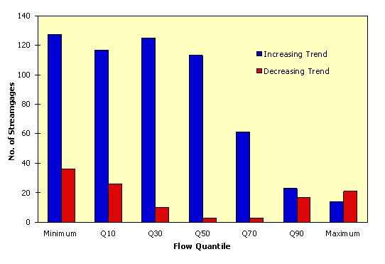
| Figure 1. Number of streamgages, out of a total of 395, with statistically significant (p<0.05) trends for the 50-year period 1944-1993. |
|
| Figure 1. Number of streamgages, out of a total of 395, with statistically significant (p<0.05) trends for the 50-year period 1944-1993. |
| Years of Record | ||||||
|---|---|---|---|---|---|---|
| 30 | 40 | 50 | 60 | 70 | 80 | |
| Beginning year Ending year Stations tested |
1993 395 |
1993 395 |
1993 395 |
1993 193 |
1993 70 |
1993 34 |
Annual minimum (daily mean) discharge | ||||||
| No. of significant trends (p<0.05) Percent with significant trends No. with increasing trend No. with decreasing trend |
28 74 38 |
45 145 32 |
41 127 36 |
44 76 9 |
49 32 2 |
38 10 3 |
Annual 10th percentile of daily discharge | ||||||
| No. of significant trends (p<0.05) Percent with significant trends No. with increasing trend No. with decreasing trend |
26 63 38 |
39 132 23 |
36 117 26 |
46 80 9 |
46 30 2 |
35 8 4 |
Annual 30th percentile of daily discharge | ||||||
| No. of significant trends (p<0.05) Percent with significant trends No. with increasing trend No. with decreasing trend |
28 76 33 |
41 148 12 |
34 125 10 |
42 79 2 |
40 27 1 |
26 8 1 |
Annual 50th percentile of daily discharge | ||||||
| No. of significant trends (p<0.05) Percent with significant trends No. with increasing trend No. with decreasing trend |
25 76 22 |
44 167 7 |
29 113 3 |
42 81 1 |
39 26 1 |
29 9 1 |
Annual 70th percentile of daily discharge | ||||||
| No. of significant trends (p<0.05) Percent with significant trends No. with increasing trend No. with decreasing trend |
15 55 4 |
33 124 6 |
16 61 3 |
30 58 0 |
27 19 0 |
18 6 0 |
Annual 90th percentile of daily discharge | ||||||
| No. of significant trends (p<0.05) Percent with significant trends No. with increasing trend No. with decreasing trend |
11 18 25 |
24 76 18 |
10 23 17 |
10 19 1 |
14 10 0 |
15 5 0 |
Annual maximum (daily mean) discharge | ||||||
| No. of significant trends (p<0.05) Percent with significant trends No. with increasing trend No. with decreasing trend |
9 12 25 |
13 31 22 |
9 14 21 |
10 11 9 |
13 5 4 |
12 2 2 |
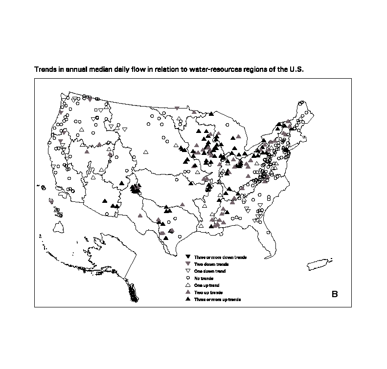
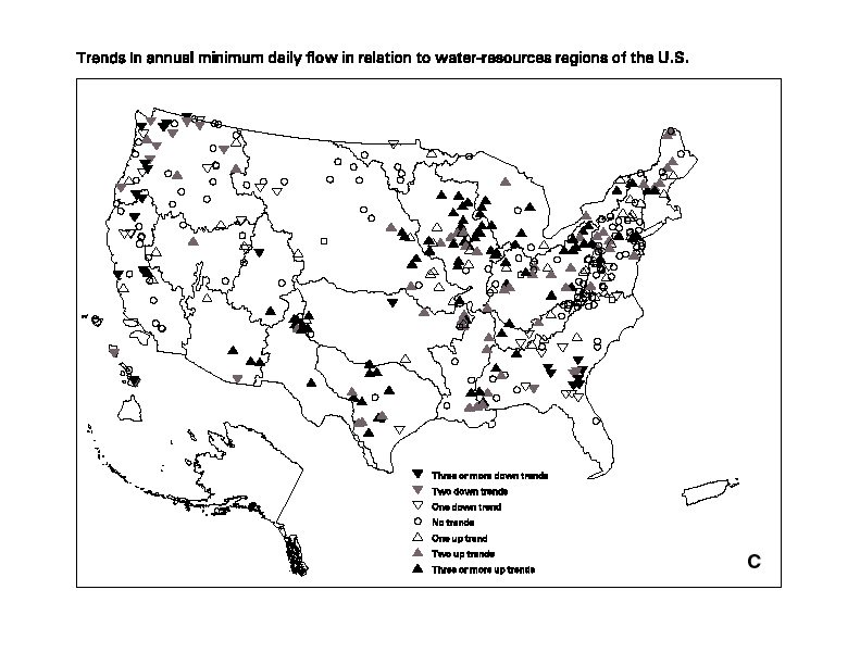
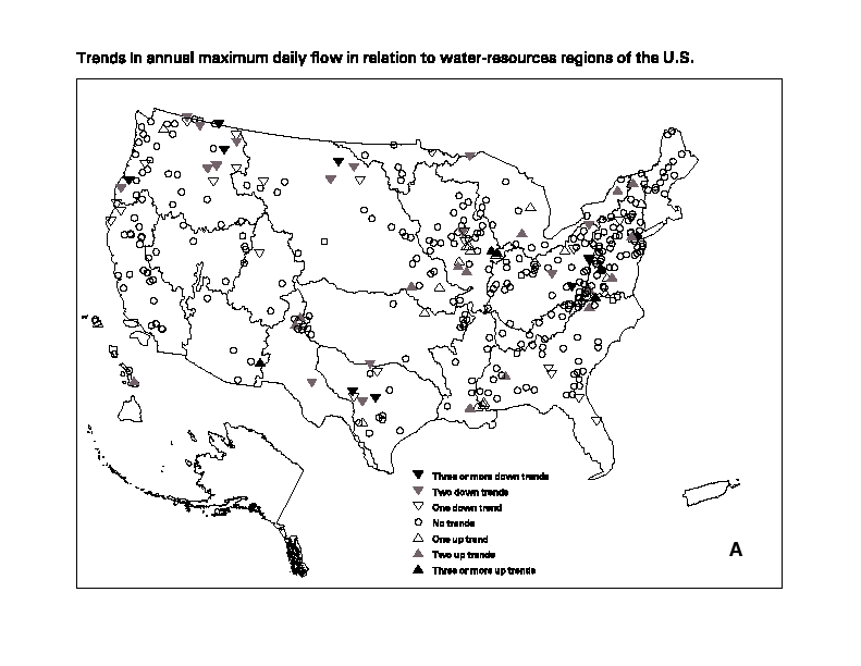 a |
b |
c |
Figure 2. Trends (p>0.05) in (a) annual maximum
daily, (b) annual median daily, and (c) annual minimum
daily discharge in relation to U.S. water resource regions.
Upward-pointing triangles indicate increasing discharge,
downward-pointing decreasing. Solid triangles
( ) denote stations
exhibiting a trend in 3 or more time periods shown in Table 1;
gray-shaded triangles ( ) denote stations
exhibiting a trend in 3 or more time periods shown in Table 1;
gray-shaded triangles ( ) denote
2 time periods; open triangles ( ) denote
2 time periods; open triangles ( ) denote a trend
in 1 time period; and an open circle ( ) denote a trend
in 1 time period; and an open circle ( ) denotes no trend in any time period. ) denotes no trend in any time period.
| ||