USGS Flood Inundation Mapping Science
Provisional data, subject to review
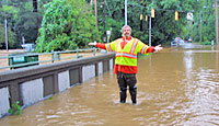
FLOOD-INUNDATION
|
Flood Inundation Map Library for the White River near Nora, Marion County, Indiana
For additional information, please see USGS Scientific Investigations Report 2011-5138. Flood-inundation areas for White River near Nora, Indiana (station 03351000)Use the links below to download flood-inundation images and geospatial data. For each stage, data is offered in two formats:
|

![]() U.S. Department of the Interior |
U.S. Geological Survey
U.S. Department of the Interior |
U.S. Geological Survey
URL: http://water.usgs.gov/osw/flood_inundation/projects/fimi/index.html
Page Contact Information: Marie Peppler
Page Last Modified: Tuesday, 25-Feb-2014 09:07:49 EST

 A digital GIS-based flood inundation mapping library for a 6-mile reach of the White River near Nora, Marion County, Indiana was created by the USGS Indiana Water Science Center. The library consists of GIS flood surfaces tied to the gage height recorded at USGS streamgage 03351000, White River near Nora, Marion County, Indiana and forecast at the collocated NWS Flood Forecast Point NORI3, White River at Nora; there are one surface produce at each 1-ft gage height from just below bank-full to the maximum expected flood level. Emergency managers, community planners, and the public will be able to access the maps quickly and relate them to forecast flood gage heights through the NWS AHPS Web service for White River at Nora.