USGS Groundwater Information
USGS Monthly Groundwater News and Highlights: June 1, 2020Subscribe to get the latest USGS groundwater news and science sent to your inbox every month! Feature: Fluoride occurrence in United States groundwater![[Map of lower 48 states presenting point data of measured fluoride concentrations. ]](images/feature/2020-06_Fluoride-Fig1.jpg "Map of lower 48 states presenting point data of measured fluoride concentrations.")
Fluoride concentrations in untreated groundwater from public-supply and domestic wells in the conterminous United States, sampled between 1988 and 2017. Source: Figure 1, McMahon and others, 2020. USGS recently completed a study of data from 38,105 wells to characterize fluoride occurrence in U.S. groundwater. Fluoride concentrations above the U.S. Environmental Protection Agency's Maximum Contaminant Level (MCL) in untreated groundwater from wells that supply drinking water were infrequent. More than 85% of drinking-water wells had fluoride concentrations below the optimal fluoride concentration for preventing tooth decay recommended by the U.S. Public Health Service. The study identified eight factors that affect fluoride concentrations, including mean annual precipitation, pH, and well depth. Study results can be used to inform decision making by domestic-well owners and others. Water Quality and COVID-19For the latest federal guidance on water quality and COVID-19, please refer to:
USGS priority is to continue the important work of the Department of the Interior and the USGS, while also maintaining the health and safety of our employees and community. Based on guidance from the White House, the CDC, and state and local authorities, we have shifted our operations to a virtual mode and have minimal staffing within our offices. These changes have also impacted recent and planned field work and field data collection activities. 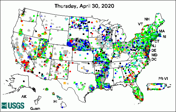 
The USGS Active Groundwater Level Network includes about 20,000 wells that have been measured by the USGS or USGS cooperators at least once within the past 13 months. The animation shows a daily snapshot of water-level statistics in the network for May 2020. Credit: USGS. The image is in the public domain. USGS Groundwater-Related PublicationsQuantifying trends in arsenic, nitrate, and dissolved solids from selected wells in Utah (05/21/20) Representing the function and sensitivity of coastal interfaces in Earth system models (05/19/20) Fluoride occurrence in United States groundwater (05/19/20)
USGS Groundwater Flow and Transport Model Data ReleasesField PhotoRecently USGS hydrogeologists conducted a field visit to this well southwest of Winslow, Arizona. USGS has been measuring groundwater levels in the well since 1969. This well, the Winslow T well (USGS site 345603110450301), is part of the Coconino Aquifer Monitoring Program in the Little Colorado River Basin. The program monitors for any changes in aquifer conditions due to increased pumping and drought conditions. Current program partners include The Navajo Nation, the City of Flagstaff, and the USGS, along with other local and State agencies. While USGS is currently operating at maximum telework, certain mission essential and critical field work has continued. We have implemented new safety and fieldwork processes to maintain social distancing to ensure the safety of our employees and communities. ![[Photo of well house surrounded by wide open space, with reddish dirt and blue skies]](images/field/2020-06_AzWSC-Winslow_T_Well_2020-04-21.jpg "Photo of well house surrounded by wide open space")
Credit: USGS/Casey Jones. Photo is in the public domain. Click on photo for larger version. Archive of Past Highlights: |
![]() U.S. Department of the Interior |
U.S. Geological Survey
U.S. Department of the Interior |
U.S. Geological Survey
URL: http://water.usgs.gov/ogw/highlights/2020-06.html
Page Contact Information: Contact the USGS Office of Groundwater
Page Last Modified: Monday, 01-Jun-2020 17:41:41 EDT
