|
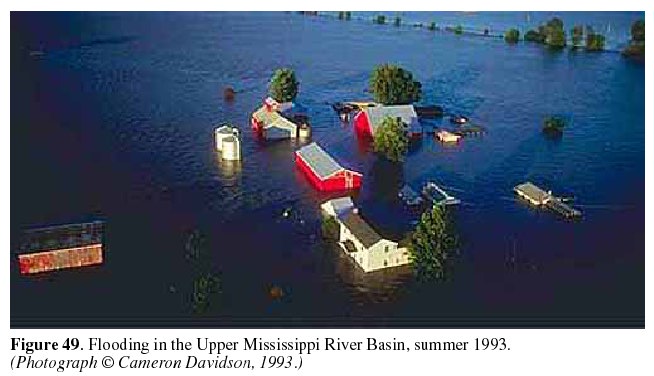
Wetlands, or the lack thereof, were a significant factor in the severe
flooding in the Upper Mississippi and Missouri River Basins in the summer
of 1993 (Parrett and others, 1993) (fig.
49). Damages associated with the flooding were undoubtedly worse than
they would have been if flood-plain wetlands had still been in place.
Human modification of the original wetlands (a common practice in the early
part of this century) had destroyed the ability of the wetlands to modify
flooding. (See the article "Effects of the Great Midwest Flood of 1993 on
Wetlands" in this volume.) Flood control, however, is only one of the
values that wetlands have for society. In order to protect wetlands, the
public first must recognize the values of wetlands. People need to
understand what is lost when a wetland is changed into an agricultural
field, a parking lot, a dump, or a housing development. Understanding the
functions of wetlands will make it easier to evaluate wetlands when other
uses are considered.
|
Not all wetlands perform all functions nor do they perform all functions equally well. |
|||||||
RECOGNITION OF WETLAND FUNCTIONS | ||||||||
|
In the 1970's, scientists, ecologists, and conservationists began to
articulate the values of wetlands. At a wetland conference in 1973,
wetlands were acknowledged to be an important part of the hydrologic cycle
(Helfgott and others, 1973). In 1977, participation at the first National
Wetland Protection Symposium-attended by more than 700 people-demonstrated
a growing interest in the value of wetlands and the need to protect them
(Kusler and Montanari, 1978). At a Wetland Values and Management
Conference in 1981, scientists defined the unique qualities of wetlands and
developed a list of wetland functions (Richardson, 1981). In addition to
the more commonly recognized habitat functions of wetlands, the scientists
described hydrologic and water-quality functions. During the 1980s,
participants at many more conferences and symposia expanded the
understanding and appreciation of the values of wetlands (Kusler and
Riexinger, 1986).
|
Wetlands are among the most productive habitats in the world.
| |||||||
WETLAND FUNCTIONS DEFINED | ||||||||
|
Wetland functions are defined as a process or series of processes that take
place within a wetland. These include the storage of water, transformation
of nutrients, growth of living matter, and diversity of wetland plants, and
they have value for the wetland itself, for surrounding ecosystems, and for
people. Functions can be grouped broadly as habitat, hydrologic, or water
quality, although these distinctions are somewhat arbitrary and simplistic.
For example, the value of a wetland for recreation (hunting, fishing, bird
watching) is a product of all the processes that work together to create
and maintain the wetland.
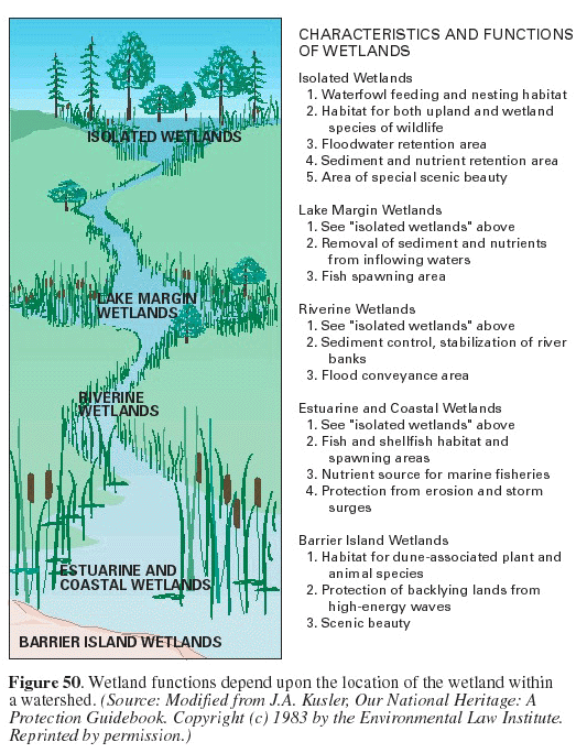
Not all wetlands perform all functions nor do they perform all functions equally well. The location and size of a wetland may determine what functions it will perform. For example, the geographic location may determine its habitat functions, and the location of a wetland within a watershed may determine its hydrologic or water-quality functions (fig. 50). Many factors determine how well a wetland will perform these functions: climatic conditions, quantity and quality of water entering the wetland, and disturbances or alteration within the wetland or the surrounding ecosystem. Wetland disturbances may be the result of natural conditions, such as an extended drought, or human activities, such as land clearing, dredging, or the introduction of nonnative species.
|
Perhaps wetlands are best known for their habitat functions, which are the functions that benefit wildlife. Habitat is defined as the part of the physical environment in which plants and animals live (Lapedes, 1976), and wetlands are among the most productive habitats in the world (Tiner, 1989). They provide food, water, and shelter for fish, shellfish, birds, and mammals, and they serve as a breeding ground and nursery for numerous species. Many endangered plant and animal species are dependent on wetland habitats for their survival. (See the article "Wetlands as Bird Habitat" in this volume.) Hydrologic functions are those related to the quantity of water that enters, is stored in, or leaves a wetland. These functions include such factors as the reduction of flow velocity, the role of wetlands as ground-water recharge or discharge areas, and the influence of wetlands on atmospheric processes. Water-quality functions include the trapping of sediment, pollution control, and the biochemical processes that take place as water enters, is stored in,or leaves a wetland. (See article "Wetland Hydrology, Water Quality, and Associated Functions" in this volume for more information on hydrologic and water-quality functions.) | |||||||
| ||||||||
WETLAND VALUES DEFINED | ||||||||
|
If something has "value," then it is worthwhile, beneficial, or desirable.
The value of a wetland lies in the benefits that it provides to the
environment or to people, something that is not easily measured. Wetlands
can have ecological, social, or economic values. Wetland products that
have an economic value, such as commercial fish or timber, can be assigned
a monetary value. True wetland value, however, goes beyond money. How
much value does one place on the beauty of a wetland or its archeological
significance? Wetland values are not absolute. What is valuable and
important to one person may not be valuable to another person. As an
example, the value of a wetland as duck habitat may be important to the
hunter or birdwatcher but not to the farmer who owns the land.
"While wetland functions are natural processes of wetlands that continue regardless of their perceived value to humans, the value people place on those functions in many cases is the primary factor determining whether a wetland remains intact or is converted for some other use" (National Audubon Society, 1993). In addition, values assigned to wetland functions may change over time as societys perceptions and priorities change. The values that benefit society as a whole tend to change slowly; however, the values assigned by individuals or small groups are arbitrary, and most are subject to rapid and frequent change and may even conflict. For example, timber production may be improved by draining a wetland site, whereas waterfowl production may be improved by impounding more water. Society may have to resolve conflicts regarding the management or preservation of wetlands and their functions. Furthermore, society may have to choose among wetland functions that benefit individuals or small groups, that are of value to most of society, or that are important to the maintenance of the wetland itself. The values that benefit society as a whole tend to change slowly; however, the values assigned by individuals or small groups are arbitrary, and most are subject to rapid and frequent change and may even conflict. For example, timber production may be improved by draining a wetland site, whereas waterfowl production may be improved by impounding more water. Society may have to resolve conflicts regarding the management or preservation of wetlands and their functions. Furthermore, society may have to choose among wetland functions that benefit individuals or small groups, that are of value to most of society, or that are important to the maintenance of the wetland itself.
|
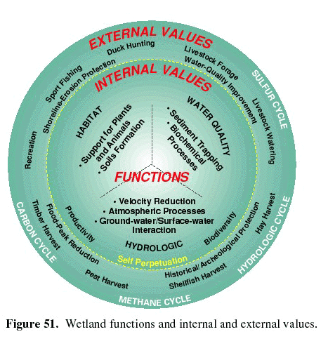
Wetland functions have value on several levels-internal, local, regional,
and global. All wetland functions are internal, but the values or benefits
of wetland functions can be internal or external to the wetland (fig. 51). Functions that provide internal values
are the functions that maintain or sustain the wetland and are essential to
the continued existence of the wetland. Conversely, many functions have
external values that extend beyond the wetland itself. On a local scale,
wetlands affect adjacent or nearby ecosystems, for example, by reducing
flooding in downstream communities or by removing nutrients from
wastewater. However, the broadest influence of wetland functions is
global. Wetlands are now thought to have a significant effect on air
quality, which is influenced by the nitrogen, sulfur, methane, and carbon
cycles. In addition, migrating birds are dependent upon wetlands as they
travel.
|
|||||||
PURPOSE OF WETLAND ASSESSMENT | ||||||||
|
Many times when decisions are made about development of an area, such as
the selection of a site for a large commercial or industrial facility, the
choice of sites is not between a wetland or an upland, but between
wetlands. In areas that have many wetlands, all alternative sites or
routes for roads for a major facility may involve the destruction or
alteration of wetlands. In such cases, legal requirements commonly exist
that require the replacement of destroyed wetlands. Even when a choice
must be made between a wetland site and an upland site, the upland site may
have great value to the community. Managers, planners, regulators, and
even the general public have long felt the need to have in place a system
of assessment or evaluation that would make the choices clearer and ensure
that the most valuable wetlands are preserved. Such an evaluation system
could be based entirely or partly on wetland function if values could be
assigned to individual functions.
Wetland assessment methods have been or are being developed that assign numerical values to wetland functions. Some methods assign values on the basis of the benefits to the wetland itself by considering the question: How important is this function in terms of maintaining this particular wetland? Other methods assign values on the basis of the benefits to surrounding ecosystems or to humans. The types of questions considered in this approach are as follows: How important is this function to environmental quality downstream? How does this function benefit society? This latter assessment method allows for the comparison of the worth of one wetland to that of another wetland.
|
The development of a single method for assessing the functions of wetlands
or for assigning values to the functions of wetlands is not a simple task.
Indeed, probably no one method will satisfy all needs. However, assessing
each function of a wetland and then assigning a value to each function is a
step toward the protection of sensitive wetlands. Furthermore, an
evaluation system that provides the basis for comparing wetlands would
facilitate mitigation for unavoidable wetland losses, would provide a tool
for determining the success (or failure) of programs and policies intended
to protect or manage wetland resources, and would assist in identifying
long-term trends in the condition of wetland resources.
|
|||||||
WETLAND ASSESSMENT METHODS | ||||||||
|
The three wetland assessment methods described herein are representative of
the methods that are available or are being used by wetland managers and
planners. The Wetland Evaluation Technique was developed for the Federal
Highway Administration and has been used widely. It assigns values to
specific functions of individual wetlands. The Environmental Monitoring
Assessment Program--Wetlands was developed by the Environmental Protection
Agency. It is presented here as an example of a program that focuses on
determining the ecological condition of a population of wetlands in a
region. It does this by comparing the function of a statistical sample of
wetlands to reference wetlands in the region. The Hydrogeomorphic approach
is being developed by the U.S. Army Corps of Engineers for assessing
wetland functions. It combines features of the other two methods by
measuring the functions of individual wetlands and also by comparing them
to functions performed by other wetlands.
|
A System of wetland assessment is necessary to ensure that the most valuable wetlands are protected. | |||||||
Wetland Evaluation Technique | ||||||||
(WET) The WET is a comprehensive approach for evaluating individual
wetlands that was developed in 1983 (Adamus, 1983; Adamus and Stockwell,
1983) and revised in 1987 under the auspices of the U.S. Army Corps of
Engineers (Adamus and others, 1987). The WET considers wetland functions
to be the physical, chemical, and biological characteristics of a wetland.
It assigns wetland values to the characteristics that are valuable to
society. The following functions are assigned values by WET:
|
The WET approach was designed to provide a balance between costly,
site-specific studies and the "best professional judgment" approach, which
is less costly but lacks reproducibility. The WET method is intended to be
used by any environmental professional, so that an engineer can evaluate
biological functions or a biologist can evaluate hydrologic functions.
First, information resources are obtained for the wetland, the area
surrounding the wetland, and the area downstream from the wetland. Then a
series of questions is answered about the wetlands watershed, topography,
vegetation, and other features. By progressing next through a series of
flow charts (or an available computer software package), an evaluation can
assign a probability rating of "high," "moderate," or "low" to each of the
functions listed above (except for recreation) and a habitat suitability
rating for waterfowl, fish, and other wildlife (Adamus, 1988). The
probability rating is an estimate of the "likelihood" that a wetland will
perform a function on the basis of its characteristics. It does not
estimate the degree or magnitude to which a function is performed.
Recreation is not evaluated because no scientific basis exists for making
an objective assessment without extensive data collection at the site. The WET approach probably has been applied to nearly every type of wetland in every State; however, it has proved to be unwieldy to use. For most users, the need to be able to apply this method to every wetland in every part of the United States makes the system unnecessarily cumbersome. For example, most users are interested in a local area and prefer not to enter data repeatedly for local characteristics that are unlikely to change, as is required in the WET approach. In order to refine the method for specific regions and to refine the thresholds among the low, medium, and high values, Adamus (1988) intended that regional versions and five different levels of WET be developed, neither of which has happened. Despite its shortcomings, however, WET continues to be used by those who are familiar with it. Furthermore, much of the data generated by its application could be used to create data bases that would simplify its use and would improve its regional application.
|
The WET evaluates functions and values in terms of effectiveness, opportunity, social significance, and habitat suitability. | ||||||
Environmental Monitoring Assessment Program-Wetlands (EMAP-Wetlands) | ||||||||
|
In 1988, the Environmental Protection Agency initiated the Environmental
Monitoring Assessment Program (EMAP) in order to provide improved
information on the status and trends in the condition of the Nations
ecological resources. The wetlands part of EMAP was intended to develop an
approach for assessing the condition (how well a wetland is performing its
functions) of different types of wetlands in a region and in the Nation as
a whole (Novitzki, 1994; Novitzki and others, 1994). The near-term
objectives of the program were to conduct research in order to identify
"indicators" of wetland condition, to standardize methods of measurement,
and to establish a national network for monitoring wetlands at regional
scales and over long periods (decades). In some places, it is impossible
or impractical to measure wetland functions directly; therefore,
characteristics or "indicators" are measured, and these indicate how well
certain functions are being performed by the wetland. For example, the
number of waterfowl per acre can be calculated from actual field
measurements and then can be used as an indicator of how well a wetland is
performing its waterfowl habitat function.
|
The EMAP-Wetlands program was intended to have three phases. First, pilot
studies were to be conducted to evaluate the ability of selected indicators
to make a distinction between healthy and degraded wetlands. Next,
regional demonstrations were to be conducted by using some of the best
indicators from the pilot studies. These demonstrations would confirm the
ability of the program to assess the condition of a specific type of
wetland in a specific region. Finally, the program would be implemented to
monitor the condition of a specific wetland type in a region. Only Phase I
has been conducted.
|
EMAP-Wetlands identifies "indicators" of condition, standardizes methods of measurement, and establishes a national network. | ||||||
|
Data from pilot and demonstration studies in Phase I are being analyzed to
develop preliminary indices of signs of the health of a wetland. One index
will be for biological integrity, which combines indicators of healthy
plant and animal communities. Biological characteristics of the sampled
wetlands will be compared with those of the most unaltered wetlands of the
same type in the region, known as reference wetlands. This comparison is
based on the assumption that the least altered wetlands have sustainable
biological integrity.
Other likely indices will be related to the following: habitat integrity (how does the population of waterfowl, finfish, or shellfish in sampled wetlands compare with that in reference wetlands?), hydrologic integrity (how similar is the hydrologic regime in the sampled wetlands to that in reference wetlands?), and water-quality improvement (how do sediment trapping and other water-quality processes in sampled wetlands compare with those in reference wetlands?). Wetland health may be evaluated either by similarity (how similar are sampled wetlands to reference wetlands?) or by biological criteria (are the sampled wetlands above or below a level determined from measurements obtained in the reference wetlands?). The comparison of the condition of sampled wetlands with the condition of reference wetlands provides a means for telling the difference between changes that result from long-term changes in climate (both sampled wetlands and reference wetlands will be affected) and changes that happen because of management actions, regulatory policy, or other human factors that affect wetlands (only the sampled wetlands will be affected).
|
Pilot studies of salt marshes in the Gulf of Mexico and prairie pothole
wetlands of the Midwest have been completed. Results of these studies have
been evaluated to identify the indicators that most effectively reveal the
difference between healthy and degraded wetlands. In the salt marshes, the
indicators that seem to hold the greatest promise (Turner and Swenson,
1994) are as follows:
|
|||||||
Hydrogeomorphic Approach (HGM) | ||||||||
|
In 1990, the U.S. Army Corps of Engineers began developing the
Hydrogeomorphic Approach (HGM) as a way to provide a foundation for
assessing the physical, chemical, and biological functions of wetlands
(Brinson, 1993; Smith and others, 1995). The program, still being
developed, is intended to revise and simplify the WET approach described
above (Adamus and others, 1987), as well as make it more applicable to
specific regions. The WET procedure develops a profile of specific
characteristics (predictors) for an individual wetland, and these are used
to assess the degree of effectiveness of the different functions of the
wetland. The HGM approach compares the characteristics of a specific
wetland with the characteristics of a group of wetlands (reference
wetlands) in the region, and this information is used to assess the degree
to which the individual wetland is performing selected functions. Thus,
the HGM approach represents a combination of the WET and EMAP-Wetlands
approaches. Wetland characteristics to be evaluated by HGM are limited to
those that are important in the specific region and hydrogeomorphic
setting. Hence, different characteristics will be identified and evaluated
for different hydrogeomorphic settings, such as closed basins in the
Midwest (for example, prairie pothole wetlands), river-edge wetlands in the
Southeast (for example, bottom-land hardwood wetlands), and coastal
wetlands (for example, salt marshes).
|
In the HGM approach, local wetland scientists or managers identify the
functions that are performed by wetlands in a specific hydrogeomorphic
setting in that region. Also, they identify wetland characteristics
(indicators), such as plant communities, plant species, and density of
stems, that suggest whether or not a wetland is performing a specific
function, such as slowing the flow velocity of floodwater. Next, the value
of each function is determined by measuring the degree to which that
function is likely to be performed. This is based on the characteristics
of the indicators. For example, if lines of debris are selected as an
indicator that a wetland has been flooded, their altitude may be used to
determine how deep the water may have been during flooding and thus how
much water may be stored in the wetland. The nature of the debris lines
also may suggest the velocity of the water as it moved through the wetland.
For example, small leaves and twigs suggest slow-moving water, small
branches suggest somewhat swifter water, and large branches and tree trunks
suggest very high velocities. Sediment deposits observed at the site may
suggest the depositional characteristics. For example, no sediment
deposits suggest little deposition, thin silt deposits suggest that
slow-moving water was sustained for long periods, and gravel and cobble
deposits might suggest that water was flowing rapidly when it entered the
site but then slowed significantly at the site.
|
The HGM approach respresents a combination of the WET and EMAP-Wetlands approaches. | ||||||
|
A wetland assessment provided by the HGM approach will likely be a "site
profile" that lists the site characteristics that are related to identified
wetland functions. This profile then will be compared with characteristics
of the reference wetlands (all wetlands in the region in the same
geomorphic class) in order to rank the site. A data base that contains
profiles of wetland characteristics (indicators of wetland functions) for
each wetland type (hydrogeomorphic class) will be established for each
region. These data will define the range of characteristics found in these
wetlands.
|
At present (1995), the HGM approach is in development and has not been
released to the public. Field tests of this assessment method have been
conducted in river-edge wetlands in the Pacific Northwest, the Northeast,
the Rocky Mountains, the Southwest, and the Southeast; in coastal wetlands
in the Pacific Northwest, the North and South Atlantic States, and the gulf
coast States; and in closed-basin wetlands in the Midwest. Data and
insights derived from these tests are being compiled and will be evaluated
in regional workshops. Following those evaluations, manuals of draft HGM
methods will be prepared and presented for comment and review in regional
workshops.
|
|||||||
| ||||||||
CONCLUSIONS | ||||||||
|
If any hope remains for preserving the Nations wetland resources, it
depends upon obtaining public support. Public support can be won if
scientists can explain clearly how wetlands function, how they interact
with their surroundings, and how their functions can benefit society.
Wetlands have come under intensive scientific study only during the last
two decades. Techniques of wetland evaluation will improve as scientists
gather more information about the processes that take place in wetlands and
about the similarities and differences among the functions of different
types of wetlands. In order to develop public support and to encourage
enlightened policy decisions and regulations, it is critical to create and
maintain a data base of wetland characteristics in which the data are
reliable, comparable, and repeatable at periodic intervals in order to
monitor long-term trends.
|
More than one approach to wetland evaluation is possible, as illustrated by
the examples discussed above. Wetland functions and their values to humans
and other living matter may be assessed for an individual wetland by using
approaches such as WET or HGM. After this, they can be compared with other
natural wetlands in a region by using the HGM approach. Both WET and HGM
can be used to determine the amount of mitigation required to offset
unavoidable wetland loss, as well as to evaluate the degree of success of
individual mitigation projects. (See article "Wetland Protection
Legislation" in this volume for further discussion of mitigation.) The
EMAP-Wetlands approach suggests that it might be possible to examine the
condition (pristine or degraded) of a population of wetlands in a specified
area. Periodic reevaluation of this population of wetlands might be used
to determine trends in their condition and to identify the effects of broad
policy decisions (such as "no net loss"), programs (such as mitigation
banking where wetlands are created or restored to offset losses of other
wetlands), or natural phenomena (such as climate change).
|
It is critical to create and maintain a data base of wetland characteristics in which the data are reliable, comparable, and repeatable. | ||||||
References Cited | ||||||||
|
For Additional Information:Richard P. Novitzki, ManTech Environmental Technology, Inc., 1600 S.W. Western Blvd., Corvallis, OR 97333;
R. Daniel Smith,
Judy D. Fretwell,
|
|||||||
Web Version by Kim Fry
Last Modified: 1345 20oct97 klf